
Fidaz landslide
The Fidaz landslide occurred on Easter Monday, April 10, 1939, east of the village of Fidaz in the municipality of Flims in the Swiss canton of Graubünden . 18 people were killed.

course
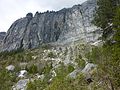
At around 11:40 a.m., small rock areas broke loose from the 400 meter high vertical rock face on the south face of the Flimserstein . Shortly afterwards, around 11:45 a.m., 100,000 cubic meters of rock fell into the valley.
The rock masses first fell in a south-easterly direction, were deflected by two huge boulders and turned south, where they buried the “Sunnehüsli” children's home. They then buried the road to Bargis and came to a standstill around 500 meters later as a closed stream. The whole crash took place in a period of 60 to 70 seconds. On the eastern edge, mighty, sharp-edged stone blocks with a size of up to 700 cubic meters characterize the picture, on the western side there are more raised earth masses.
In addition to the children's home, 10 hectares of forest, a stable with four animals and a mountain hut were destroyed . 17 hectares of meadow land were covered with rubble. Even if the debris flow is partly overgrown again thanks to immediate reforestation, it can still be clearly seen in the terrain.
2010, on the right the lighter breaking point

Landslide area downhill


numbers

The demolition point was between 1,600 and 1,800 meters above sea level. The material dissolved over an average width of 75 meters, resulting in a demolition area of 15,000 square meters. The rock masses tore a further 300,000 cubic meters with them when they hit the foot of the vertical rock wall, so that the entire deposit area is at least 400,000 cubic meters. Another calculation model resulted in a sediment mass of 723,000 cubic meters.
The maximum width of the lintel was around 320 meters; the maximum flow height of 14 meters was reached at that point. The rock material consists of Malmkalk (Quintnerkalk and Riffkalk ).
The Flims hotelier's son Roman Bezzola (later director of the Park Hotels Waldhaus ), who happened to be on the Pinut , managed to take two pictures of the masses rolling down into the valley under the steep face within around five seconds. On the basis of a boulder clearly visible in both images, its mean speed was calculated at around 25 meters per second, which corresponds to an hourly speed of 125 km / h. Model calculations showed a maximum speed of 200 km / h.
root cause
The cause of the rock fall lies in the strong fissures of the Flimserstein; the fall occurred along a vertical chasm . After the fall, clear differences in color could be seen in the rock: the lower third of the broken area was bluish-white, the upper two-thirds were dark yellow. This shows that there, parallel to the wall, water and air must have penetrated deep into the interior, which promoted mechanical and chemical weathering processes. Finally the lower part could no longer withstand the increasing pressure of the upper part and broke away. Infiltrated seepage water, however, probably played no role; the dry rock debris and the large amount of dust speak against it.
Children's home
At the eastern end of Fidaz, above the road to Bargis, at the edge of the forest stood the “Sunnehüsli” (“sun house”) children's home. The owner and operator was W. Gessler-Brandenberger.
In the landslide, 18 of the 29 residents, 5 adults and 13 children, were killed. One adult and four children remain buried under the rubble to this day. The cemetery at the approximate location of the home on the western edge of the rubble field applies to them. Relatives also had a memorial stone erected for individual victims. The names of all victims - their international origin is striking - are engraved on a plaque.
gallery

Fidaz mountain cemetery with the memorial stele, donated by the director of the Turkish sugar industry, whose son was among the victims.
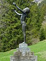
Bronze figure by the Zug sculptor Wilhelm Schwerzmann , dated 1925

Memorial stones for victims not found

Memorial plaque to all victims

The landslide area seen from Il Bot.


literature
- Emil Kirchen: When the mountain falls: the landslide area between Chur and Ilanz - Chur [etc.]: Terra Grischuna , cop. 1993. [000943845] ISBN 3-7298-1087-1
- Yvonne Rogenmoser: The Flims rockslide between two book covers , Versam 2012
Web links
- Analysis and simulation (PDF file; 1.28 MB)
Individual evidence
- ↑ Analysis and simulation, page 5 ( Memento of the original from January 16, 2016 in the Internet Archive ) Info: The archive link was inserted automatically and has not yet been checked. Please check the original and archive link according to the instructions and then remove this notice. (PDF file; 1.28 MB)
- ↑ PDF page 7 ( Memento of the original from January 16, 2016 in the Internet Archive ) Info: The archive link was inserted automatically and has not yet been checked. Please check the original and archive link according to the instructions and then remove this notice.
- ↑ Yvonne Rogenmoser.ch ( Memento from January 3, 2017 in the Internet Archive )
Coordinates: 46 ° 51 ′ 0 " N , 9 ° 18 ′ 48" E ; CH1903: 742968 / 190470