
Berneray Causeway


The Berneray Causeway is an embankment that connects the Hebridean Islands of Berneray and North Uist . It is part of a network of dams and bridges that connect the largest islands in the Uist archipelago . It crosses the Berneray Sound with a length of about 870 m .
Planning for the Berneray Causeway began in 1991. The aim was to better connect the island of Berneray to the larger, southern islands. As between other islands in the Outer Hebrides, a dam was considered the most appropriate solution for this purpose. Construction began in 1997. In total, more than 300,000 t of rock material had to be moved that came from a nearby quarry. This was closed again after the construction work was completed and the site was renatured. About two thirds of the construction workers came from the region. The two-lane connecting road between the islands leads over the 10 m wide dam. There are openings for otters on both coasts ; In the middle of the structure there is a 2 × 3 m wide passage for marine animals. Furthermore, fences have been installed to prevent rabbits from migrating to Berneray and thus to protect the island's ecological system. The total cost was £ 6.6 million . Prince Charles ceremoniously opened the dam on April 8, 1999, although it had previously been used unofficially.
The traffic route replaces a ferry connection, which was previously the only connection between the islands. The last ferry ran from Berneray to North Uist on December 17, 1999. Numerous islanders crossed on this trip and then hiked back over the dam to Berneray.
Archaeological finds
In the run-up to construction, archaeological investigations were carried out on the affected areas. Traces of Neolithic settlement were discovered here; Furthermore, over 150 clay vessels, flint and tools made of quartz stone as well as signs of post-medieval development with a port facility and a quarry. A cairn measuring 8 × 8.8 m and about half a meter high was also exposed. It is probably a Bronze Age burial place. The Cairn was preserved, which resulted in changes to the project planning. A 3 × 3 m cairn, probably of Pictish origin, was found in 1998. It was not uncovered, but mapped and preserved by relocating the route.

Inscription in the memorial stone for the opening of the dam
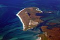
Aerial view

Otters settle in the coastal areas


Individual evidence
- ↑ a b Entry in the Gazetteer for Scotland
- ↑ a b c Entry on cne-siar.gov.uk ( Memento from June 29, 2011 in the Internet Archive )
- ↑ Western Isles Council (Berneray Causeway) Order Confirmation Act 1996 (PDF; 134 kB)
- ↑ Entry on Berneray Causeway in Canmore, the database of Historic Environment Scotland (English)
Coordinates: 57 ° 42 ′ 1 ″ N , 7 ° 11 ′ 10 ″ W.