Bhagirathi (mountain)
| Bhagirathi I | ||
|---|---|---|
|
Bhagirathi massif |
||
| height | 6856 m | |
| location | Uttarakhand ( India ) | |
| Mountains | Gangotri Group ( Garhwal Himalaya ) | |
| Dominance | 6.08 km → Satopanth | |
| Notch height | 650 m | |
| Coordinates | 30 ° 51 '1 " N , 79 ° 8' 57" E | |
|
|
||
| First ascent | 1980 by a japan. expedition | |
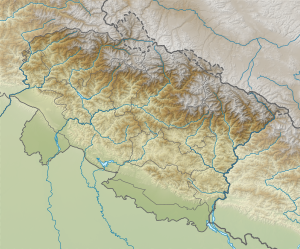
The Bhagirathi , also Bhagirathi Parbat , (main peak: Bhagirathi I ) is a 6856 m high mountain in the Indian state of Uttarakhand in the Garhwal Himalayas .
The mountain is located on the eastern side of the Gangotrig glacier . It has two secondary peaks that lie north of the main peak: Bhagirathi II (6512 m, ⊙ ) in the north of the mountain range and Bhagirathi III (6454 m, ⊙ ) between the other two peaks. On the northern flank of the mountain range, the Chaturangi glacier flows in a westerly direction towards the Gangotrig glacier.
First ascents of the peaks
The first ascent of Bhagirathi I took place in 1980 by a Japanese expedition over the southeast ridge. The first ascent of Bhagirathi II took place in 1938 by a German-Austrian expedition over the northeast face led by Rudolf Schwarzgruber . The first ascent of Bhagirathi III was achieved on June 18, 1933 by the two British Colin Kirkus and Charles Warren over the southeast ridge.
Web links
- Bhagirathi at Peakware (English)

