Big Salmon River (New Brunswick)
| Big Salmon River | ||
|
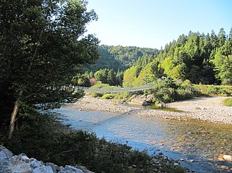
Suspension bridge over the Big Salmon River |
||
| Data | ||
| location | New Brunswick ( Canada ) | |
| River system | Big Salmon River | |
| origin | Walton Lake, southwest of Sussex 45 ° 36 ′ 29 ″ N , 65 ° 19 ′ 9 ″ W |
|
| Source height | approx. 220 m | |
| muzzle | at Salmon River near St. Martins in the Bay of Fundy Coordinates: 45 ° 25 ′ 13 " N , 65 ° 24 ′ 4" W 45 ° 25 ′ 13 " N , 65 ° 24 ′ 4" W |
|
| Mouth height | 0 m | |
| Height difference | approx. 220 m | |
| Bottom slope | approx. 7.9 ‰ | |
| length | 28 km | |
| Catchment area | 287 km² | |
| Discharge A Eo : 287 km² Location: 1 km above the mouth |
MQ 1971/1978 Mq 1971/1978 |
11.8 m³ / s 41.1 l / (s km²) |
| Right tributaries | Northwest Branch Big Salmon River | |
The Big Salmon River (English for "large salmon river") is a 28 km long river in the southeast of the Canadian province of New Brunswick .
River course
The Big Salmon River drains the 220 m high Walton Lake , southwest of Sussex . It flows in a predominantly south-southwest direction. 5 km above the mouth, the Northwest Branch Big Salmon River meets the Big Salmon River when coming from the right. This finally flows into the Bay of Fundy near St. Martins . The river flows through Kings County and Saint John Counties . The end point of the Fundy Trail is at the river .
Hydrology
The Big Salmon River has a catchment area of 287 km². The mean discharge is 11.8 m³ / s. In April and May the river carries the largest amount of water with an average of 20.4 and 26.6 m³ / s.
Web links
- Fundy Trail Parkway
- "Big Salmon River." GeoNames, n.d. Web. 14 Mar 2016
- Big Salmon River at Natural Resources Canada: Place names, accessed March 16, 2016
