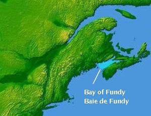
Bay of Fundy
| Bay of Fundy Baie de Fundy |
|
|---|---|
|
The Bay of Fundy at high and low tide |
|
| Waters | Atlantic Ocean |
| Land mass | Mainland North America , Nova Scotia Peninsula |
| Geographical location | 45 ° 0 ′ N , 65 ° 48 ′ W |
| width | 60 km |
| depth | 220 km |
| Tributaries | Saint Croix River , Magaguadavic River , Saint John River , Petitcodiac River , Tantramar River |
|
Alma Harbor as the tide sets in |
|
The Bay of Fundy ( English also Fundy Bay; French Baie de Fundy) is located between the Canadian provinces of Nova Scotia and New Brunswick on the Gulf of Maine with a length of 220 and a width of 60 kilometers. It is characterized by its exceptionally high tidal range of up to 21 meters. Its name is derived from the Portuguese name Rio Fondo ("deep river").
The first European description of the bay comes from the year 1604 by the French explorer Pierre Dugua de Mons and his cartographer Samuel de Champlain as Baie François.
The bay's largest ports are Saint John , which supplies a paper mill and a refinery , Hantsport with another paper mill, as well as a gypsum export port and Digby .
tide
In the western part of the Bay of Fundy is Passamaquoddy Bay , which lies between the US state of Maine and the Canadian province of New Brunswick. At its end the bay runs out in two arms, to the west the Chignecto bay and to the east the Minas Channel with the adjoining Minas Basin.
The Minas Basin has the highest tidal differences in the world. The tidal range is around 13 meters at normal high tide and around 16 meters at spring tide . Intensified by a storm, even 21.6 meters were measured in 1869. For Chignecto Bay, the values are about 1.5 meters lower. This enormous tidal range is the result of a particularly pronounced tidal resonance here . The bay forms a resonator up to the edge of the shelf .
The Annapolis tidal power station has been using the tidal range since 1984 to generate electricity with an output of 18 MW . Further tidal and ocean current power plants of various designs are being planned. In trial operation from November 2016 to March 2017, a power plant ran in the Minas Basin at Burntcoat Head, which floated freely in the water due to its weight and was only slightly anchored on the ground. The plant has a turbine diameter of 16 meters, a total height of 20 meters and a total weight of around 1000 tons and generates up to 2 megawatts. Contrary to the plan, which provided for 5 years of trial operation, the plant had to be shut down after 4 months; His recovery took another 3 months due to unplanned technical problems and required the dangerous use of divers. This shortened period of 1500 operating hours also provided important data for the future operation and improvement of the machines. In August 2018, the operator Open Hydro declared itself insolvent, the trial operation is suspended. The assessment at this point is that the attempt has finally failed.
A few kilometers north of Fundy National Park are the Hopewell Rocks , where the effect of the tides on rock formations can be seen.
In the eastern foothills, the Minas Basin, almost 40,000 hectares of mud flats fall dry when the water is low .
nature
It is also known for its impressive and rough rock formations and forests on the rugged coast. A part of them covering 20,700 hectares was declared a national park in 1948.
The marine fauna in the bay is very distinctive. The cool, nutrient-rich water in the bay makes for a rich population of krill , which attracts various species of whales such as right whales , humpback whales, and minke whales . The bird world is also diverse, such as puffins , terns , peregrine falcons and bald eagles on the coast . During train times, large crowds of sand beach walkers also gather here .
Herring , American lobster , mussels and salmon are important for the local fishery in aquaculture .
Islands
- Grand Manan Island borders the Gulf of Maine.
|
in Passamaquoddy Bay: |
before Cape Chignecto: in the Minas Basin: |
There are also smaller islands in Passamaquoddy Bay, in the neighboring Back Bay and in the Annapolis Basin .
Tributaries
|
in New Brunswick: |
in Nova Scotia: |
Movie
- Water worlds. Bay of Fundy - Highest tidal range. (Original title: Les mondes inondés. Baie de Fundy - Les plus hautes mareés du monde.) Documentary, France, 2014, 42:50 min., Script : Eric Gonzalez, Marie Pilhan, Michel Ismaël Khelifa, director: Frédéric Fèbvre, production: One Planet, arte France, series: Wasserwelten, German first broadcast: October 24, 2014 on arte.
Web links
- Bay of Fundy Ecosystem Partnership (English)
Individual evidence
- ↑ Detailed description of the trial run
- ↑ Canadian turbine recovered with difficulty
- ↑ Setback for tidal power plants: Open Hydro is broke
- ↑ JA Percy: Fundy's Minas Basin. Multiplying The Pluses of Minas, in: The Fundy Issues, Spring 2001.


