Grand Manan Island
| Grand Manan Island | ||
|---|---|---|
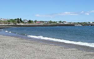
| Beach at North Head | ||
| Waters | Bay of Fundy | |
| Archipelago | Grand Manan Archipelago | |
| Geographical location | 44 ° 42 ′ N , 66 ° 48 ′ W | |
|
|
||
| length | 34 km | |
| width | 18 km | |
| surface | 137 km² | |
| Highest elevation | 78 m | |
| Residents | 2460 (2006) 18 inhabitants / km² |
|
| main place | Grand Harbor | |
| official municipal coat of arms | ||
Grand Manan Island (or simply Grand Manan ) is a Canadian island, the largest in the Bay of Fundy . It is also the main island of the Grand Manan Archipelago and is located on the border between the Bay of Fundy and the Gulf of Maine . Grand Manan is part of Charlotte County within the province of New Brunswick . In 2006 the island had 2,460 inhabitants.
geography
Grand Manan Island is located at latitude 44 ° 42 'north and longitude 66 ° 48' west of the east coast of the North American continent. It is located at the western exit of the Bay of Fundy, a marginal sea of the Atlantic between the provinces of New Brunswick and Nova Scotia , whose tides are among the strongest in the world. It is 20 miles south of Blacks Harbor and the closest point on the mainland is in Washington County , Maine, near Lubec (the easternmost parish in the US). Here the distance to the mainland on the other side of the Grand Manan Channel is 15 km. Grand Manan is 34 km long and a maximum of 18 km wide and has an area of 137 km².
The vast majority of the population live on the east side of the island. Because of its inaccessibility, the almost 100 meter high cliffs and the strong winds, the west side of the island is not populated, although there are wind turbines in Dark Harbor as well as an algae farm and a holiday resort for islanders there. Grand Manan has a network of trails for 4x4, hiking, mountain biking, and nature watching, and it is challenging terrain for jogging. There are a number of freshwater ponds and lakes and ocean beaches that are popular spots for sunbathing, shell-collecting, and picnicking. Other interesting discoveries on Grand Manan Island include magnetic sand and the Hole-In-The Wall at Whale Cove in the village of North Head. The Anchorage Provincial Park is located on the southeast coast of the island between the villages of Grand Harbor and Seal Cove.
White Head Island, Gull Rock, Machias Seal Island, and North Rock are part of the wider Grand Manan group of islands. The latter two are about 15 km southwest of Grand Manan Island. Both Machias Seal Island and North Rock are claimed by the United States and Canada. Administratively, they represent the southernmost part of the province of New Brunswick. Machias Seal Island is also home to the last manned lighthouse in the province. The beacon has operated continuously since 1832. The position of lighthouse keeper was canceled in the 1990s for cost reasons, but was soon reintroduced as a symbol of national sovereignty. The Atlantic Cooperative Wildlife Ecology Research Network at the University of New Brunswick in Fredericton is conducting research on the island .
Anchorage Provincial Park is located on the island .
history
discovery
"Manan" is a corruption of "mun-an-ook" or "man-an-ook", which means "island place" or "the island" in the language of the Maliseet-Passamaquoddy-Penobscot Indians ("-ook" means " People from ”). Oral tradition has it that these indigenous people used Grand Manan and the surrounding islands as a safe place for the elders of the people and a sacred burial place during the winter months. It is believed that Vikings were the first Europeans to visit Grand Manan Island while exploring the Bay of Fundy and the Gulf of Maine around the year 1000. In the late 15th century, famous explorers Sebastian Caboto and Gaspar Corte-Real likely saw what is now Grand Manan and the Bay of Fundy while exploring the New World separately. During the early 16th century, Breton fishermen are said to have fished in the rich waters around the island and sought shelter in their ancient oak forests.
The Portuguese explorer João Álvares Fagundes mapped the region around Grand Manan Island around 1520, but the island does not appear clearly on any map before 1558. Reports of rich lands led the Portuguese to consider the area significant enough to include on a comprehensive map of the New World. The famous cartographer Diogo Homem made this map and recorded the later Grand Manan and surrounding islands. It is believed that the name “Fundy” goes back to the time when the Portuguese and Breton fishermen called the bay the “Rio Fundo” or “deep river”.
It is likely that the map aroused a fascination for the region with the French trader and explorer Stephen Bellinger (Étienne Bellenger). Desiring to benefit from the riches of this newly discovered paradise, Bellinger set sail aboard the Chardon in January 1583 and reached Cape Breton around February 7th. He sailed along one side of what is now Nova Scotia and came to the "great bay of this island", namely the Bay of Fundy (Baie Française). Since he noted that the "driveway is so narrow that a Kalverine shot can reach the other from one side," it appears that he drove between Long Island and Digby Neck into the bay (if the coastline has not changed since then should have changed).
He named many places as he explored the bay and some of the places he gave along the north coast survived his voyage. It appears that he left the Bay of Fundy between the island of Grand Menane (Grand Manan) and what is now Maine.
A dinghy of Chardon Bellinger ten to twelve times went ashore. He carefully inspected the resources on the mainland, its wood stocks, its salt production possibilities, its presumed mineral wealth and brought home some ores which presumably contained lead and silver. He also had frequent contact with the Passamaquoddy Penobscot Indians. He stated that the "natives" who lived 60 to 80 leagues west of Cape Breton were cunning, cruel and deceitful: he lost two men and his dinghy while driving back along the coast of Nova Scotia. However, he found the Passamaquoddy Indians further west and gentle and approachable in what is now Maine and Grand Manan. He had a certain number of small items with him to trade in and in return received various game products from the Indians.
In 1606, the French explorer Samuel de Champlain sailed through the Bay of Fundy during a voyage on behalf of King Henry IV and sought shelter on White Head, a side island of Grand Manan, during a storm that March. Seven years later, de Champlain made a detailed map of what he had seen and named the "big" island "Manthane", which he later changed to Menane or Menasne. "Grand" was later officially added to the name.
In 1693 the island of Grand Manan was awarded to Paul D'Ailleboust, Sieur de Périgny, as part of Champlains " New France ". D'Ailleboust did not take possession of it and the island fell back to the French crown, where it remained until 1713 when it came to Great Britain in the Peace of Utrecht .
Colonial times
Despite exploration and trading activities in previous years, the first permanent settlement on Grand Manan was not established until 1784 when Moses Gerrish gathered a group of settlers in an area he called Ross Island in honor of settler Thomas Ross.
That was when the United States came into being. Due to the Peace of Paris in 1783, the United States considered Grand Manan Island its rightful possession because of its proximity to Maine. For many years the United States and Britain argued over Grand Manan. The Jay Treaty of 1794 enshrined Britain's rights to Grand Manan Island while giving up control of the islands of Eastport Moose, Frederick and Dudley in nearby Cobscook Bay .
However, the ownership of the respective country was not entirely clear among the traders of the time.
From the 19th century to the present
During the period from 1812 to 1814, the Bay of Fundy was invaded by privateers. With the ongoing dispute between British loyalists and the United States over the resources and strategic location of Grand Manan Island, the island almost sparked another war between the two countries. The settlers on Grand Manan had to endure a lot during these years, as privateers from both sides often raided and plundered the villages on the east coast of the island.
The exact course of the border and sovereignty over the islets in Passamaquoddy Bay were not finally established until 1817, when Great Britain received unrestricted rule over Grand Manan and the surrounding islands from the United States.
By 1832, the island had become a destination for people seeking prosperity and seclusion. The Anglican Church set up schools on site. While the neighboring islands along the American coast as far as Boston relied mainly on whaling, Grand Manan was known for shipbuilding and fishing. In the early 19th century, larch, birch and oak were cleared and the shipbuilding industry flourished. The island's population grew and produced many good carpenters. Grand Manan Island was known for its accomplished shipbuilders.
During this time there were also a number of shipwrecks off the island's rocky, cliff-rich coast. One of the most famous of these shipwrecks, that of Lord Ashburton , occurred in the winter of 1857. The barque had crossed the Atlantic from Toulouse . Less than 60 miles from her port of destination, Saint John , the Lord Ashburton was driven by a hurricane onto the cliffs at the north end of Grand Manan Island. The captain, three mates and the 28 members of the crew were washed overboard. Only eight of the men survived and were taken care of by villagers. The bodies of those who died were recovered from below the cliffs the next day and buried in the cemetery in North Head village, where a memorial was later erected in memory of them.
In 1851 the island had nearly 1,200 permanent residents, most of whom were involved in the now hugely successful fishing industry.
Web links
Individual evidence
- ↑ Archive link ( Memento of the original dated November 23, 2010 in the Internet Archive ) Info: The archive link was inserted automatically and has not yet been checked. Please check the original and archive link according to the instructions and then remove this notice.
- ↑ Grand Manan Island ( English, French ) In: The Canadian Encyclopedia . Retrieved August 21, 2016.


