Washington County (Maine)
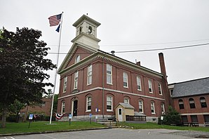
 Washington County Courthouse in Machias |
|
| administration | |
|---|---|
| US state : | Maine |
| Administrative headquarters : | Machias |
| Foundation : | |
| Demographics | |
| Residents : | 32,856 (2010) |
| Population density : | 4.9 inhabitants / km 2 |
| geography | |
| Total area : | 8430 km² |
| Water surface : | 1778 km² |
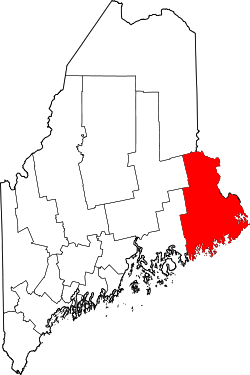
| map | |
Washington County is a county in the state of Maine in the United States . The county seat is Machias .
Washington County is sometimes referred to as the Sunrise County because this easternmost county rises earlier than the rest of the United States. The county is named after George Washington .
economy
Washington County's economy is primarily focused on fishing, logging and, to a lesser extent, tourism. There are no large commercial enterprises; tourism is also not as strong as in the rest of Maine.
The blueberry harvest has a special status for the county: 90 percent of US production is here.
geography
According to the US Census Bureau , the county has a total area of 8,430 square kilometers. 1778 square kilometers, or 21.09 percent, are water areas. Washington has the easternmost mainland point in the United States in the small town of Lubec . The easternmost point is the town of Eastport , located on a barrier island .
The highest tidal fluctuations occur along the Washington County coast : averaging about 6.5 meters (18 feet) on the coast at Lubec, Jonesport and Eastport, and even about 7 meters (20 feet) at the mouth of the St. Croix River at Calais . The county is bordered clockwise by the counties: York County, New Brunswick, Canada, Charlotte County, New Brunswick, Canada, Hancock County , Aroostook County, and Penobscot County .
history
100 buildings and sites in the county are listed on the National Register of Historic Places (as of November 11, 2017).
Demographic data
| growth of population | |||
|---|---|---|---|
| Census | Residents | ± in% | |
| 1790 | 2758 | - | |
| 1800 | 4461 | 61.7% | |
| 1810 | 7870 | 76.4% | |
| 1820 | 12,744 | 61.9% | |
| 1830 | 21,294 | 67.1% | |
| 1840 | 28,327 | 33% | |
| 1850 | 38,811 | 37% | |
| 1860 | 42,534 | 9.6% | |
| 1870 | 43,343 | 1.9% | |
| 1880 | 44,484 | 2.6% | |
| 1890 | 44,482 | -0% | |
| 1900 | 45.232 | 1.7% | |
| 1910 | 42,905 | -5.1% | |
| 1920 | 41,709 | -2.8% | |
| 1930 | 37,826 | -9.3% | |
| 1940 | 37,767 | -0.2% | |
| 1950 | 35,187 | -6.8% | |
| 1960 | 32,908 | -6.5% | |
| 1970 | 29,859 | -9.3% | |
| 1980 | 34,963 | 17.1% | |
| 1990 | 35,308 | 1 % | |
| 2000 | 33,941 | -3.9% | |
| 2010 | 32,856 | -3.2% | |
| Before 1900; 1900-1990; 2000 + 2010 | |||

The county had a population of 33,941 as of the 2000 census . There were 14,118 households and 9,303 families. The population density was 5 people per square kilometer. The racial population was composed of 93.48% white, 0.26% African American, 4.43% Native American (mostly Passamaquoddy ), 0.30% Asians, 0.01% residents from the Pacific island area and 0.44 % from other races; 1.07% were from two or more races. Hispanic or Latino of any race was 0.81% of the population.
Of the 14,118 households, 28.00% had children and young people under the age of 18 living with them. 52.10% were married couples living together, 9.50% were single mothers. 34.10% were not families. 28.30% are single households and 13.10% have someone who is 65 years of age or older. The average household size was 2.34 and the average family size was 2.84 people.
For the entire county, the population was composed of 22.90% residents under 18 years of age, 8.00% between 18 and 24 years of age, 26.30% between 25 and 44 years of age, 25.60% between 45 and 64 years of age 17.30% were 65 years of age or over. The average age was 40 years. For every 100 females there were 95.50 males, and for every 100 females aged 18 and over there were 93.90 males.
The median income for a household in the county is $ 25,869 , and the median income for a family is $ 31,657. Males had a median income of $ 28,347 versus $ 20,074 for females. The per capita income was $ 14,119. 19.00% of the population and 14.20% of families are below the poverty line. 22.40% of these were under 18 years of age and 19.20% were 65 years of age or older.
cities and communes
Washington County is divided into 51 administrative units: two cities , 39 towns, and three plantations ; two areas are Indian reservations , there are two unorganized territories and three census-designated placees .
| Locality | status | Population (2010) |
Total area [km²] |
Land area [km²] |
Population density [inhabitants / km²] |
founding |
|---|---|---|---|---|---|---|
| Addison | Town | 1,266 | 260.2 | 109.9 | 11.5 | February 14, 1797 |
| Alexander | Town | 499 | 118.2 | 104.0 | 4.8 | January 19, 1825 |
| Baileyville | Town | 1,521 | 108.6 | 96.2 | 15.8 | February 19, 1828 |
| Baring | Plantation | 251 | 62.0 | 54.0 | 5.0 | January 10, 1825 |
| Beals | Town | 508 | 125.2 | 14.6 | 34.9 | April 7, 1925 |
| Beddington | Town | 50 | 98.1 | 89.6 | 0.5 | January 31, 1833 |
| Calais | City | 3.123 | 103.9 | 88.9 | 30.0 | June 16, 1809 |
| Charlotte | Town | 332 | 87.4 | 80.3 | 4.1 | January 19, 1825 |
| Cherryfield | Town | 1,232 | 116.5 | 115.1 | 10.7 | February 9, 1816 |
| Codyville | Plantation | 24 | 142.0 | 142.0 | 0.1 | March 29, 1871 |
| Columbia Falls | Town | 560 | 63.9 | 63.6 | 8.8 | March 25, 1863 |
| Columbia | Town | 486 | 94.8 | 94.0 | 5.2 | February 8, 1796 |
| cooper | Town | 154 | 84.4 | 79.5 | 1.9 | February 6, 1822 |
| Crawford | Town | 105 | 97.9 | 89.4 | 1.2 | February 11, 1828 |
| Cutler | Town | 507 | 305.4 | 121.6 | 4.2 | January 28, 1826 |
| Danforth | Town | 589 | 156.6 | 139.9 | 4.2 | March 17, 1860 |
| Deblois | Town | 57 | 93.5 | 92.8 | 0.6 | March 4, 1852 |
| Dennysville | Town | 342 | 39.6 | 38.6 | 8.8 | February 13, 1818 |
| East Machias | Town | 1,368 | 103.7 | 90.2 | 15.2 | January 26, 1826 |
| Eastport | City | 1,331 | 32.0 | 9.4 | 42.0 | February 24, 1798 |
| Grand Lake Stream | Plantation | 109 | 126.1 | 114.5 | 0.9 | January 25, 1798 |
| Harrington | Town | 1.004 | 130.3 | 54.7 | 18.4 | June 17, 1797 |
| Jonesboro | Town | 583 | 99.4 | 94.7 | 6.1 | March 4, 1809 |
| Jonesport | Town | 1,370 | 259.9 | 73.8 | 18.6 | February 3, 1832 |
| Lubec | Town | 1,359 | 203.0 | 86.1 | 15.8 | June 21, 1811 |
|
Machias ( County Seat ) |
Town | 2,221 | 38.3 | 35.9 | 61.8 | June 23, 1784 |
| Machia sport | Town | 1,119 | 159.6 | 55.5 | 20.2 | January 24, 1826 |
| Marshfield | Town | 518 | 45.4 | 44.1 | 11.8 | June 30, 1846 |
| Meddybemps | Town | 157 | 41.6 | 34.0 | 4.6 | February 20, 1841 |
| Milbridge | Town | 1,353 | 189.0 | 62.8 | 21.5 | July 14, 1848 |
| Northfield | Town | 148 | 118.7 | 112.9 | 1.3 | March 21, 1838 |
| Pembroke | Town | 840 | 91.3 | 70.9 | 11.9 | February 4, 1832 |
| Perry | Town | 889 | 108.9 | 75.8 | 11.7 | February 12, 1818 |
| Princeton | Town | 832 | 108.2 | 95.4 | 8.7 | February 3, 1832 |
| Robbinston | Town | 574 | 87.4 | 73.0 | 7.9 | February 18, 1811 |
| Roque Bluffs | Town | 303 | 50.6 | 26.9 | 11.3 | March 12, 1891 |
| Steuben | Town | 1,131 | 193.7 | 111.3 | 10.2 | February 27, 1795 |
| Talmadge | Town | 64 | 101.2 | 97.9 | 0.7 | February 28, 1875 |
| Topsfield | Town | 237 | 143.3 | 129.7 | 1.8 | February 24, 1838 |
| Vanceboro | Town | 140 | 58.0 | 52.2 | 2.7 | March 4, 1874 |
| Waite | Town | 101 | 114.1 | 113.9 | 0.9 | February 22, 1876 |
| Wesley | Town | 98 | 131.2 | 129.2 | 0.8 | January 24, 1833 |
| Whiting | Town | 487 | 134.9 | 121.1 | 4.0 | February 15, 1825 |
| Whitneyville | Town | 220 | 39.4 | 38.5 | 5.7 | February 10, 1845 |
- Lubec (CDP) (1,359)
- Machias (CDP) (1,274)
- Woodland (CDP) (952)
- East Central Washington (728)
- North Washington (499)
Individual evidence
- ↑ GNIS-ID: 581300. Retrieved on February 22, 2011 (English).
- ↑ Search mask database in the National Register Information System. National Park Service , accessed November 11, 2017.
- ↑ US Census Bureau - Census of Population and Housing . Retrieved March 15, 2011
- ↑ Extract from Census.gov . Retrieved February 28, 2011
- ↑ Extract from census.gov (2000 + 2010). Accessed April 2, 2012
- ↑ a b Extract from the National Register of Historic Places . Retrieved March 13, 2011
- ^ Official website of the Maine administration
- ↑ Population data from the 2010 US Census in the American Factfinder
Web links
Coordinates: 44 ° 58 ′ N , 67 ° 37 ′ W


