Cumberland County (Maine)
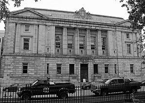
 Cumberland County Courthouse |
|
| administration | |
|---|---|
| US state : | Maine |
| Administrative headquarters : | Portland |
| Foundation : | 1760 |
| Demographics | |
| Residents : | 281,674 (2010) |
| Population density : | 130.2 inhabitants / km 2 |
| geography | |
| Total area : | 3,152 km² |
| Water surface : | 988 km² |
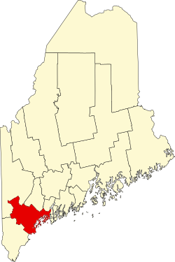
| map | |
| Website : www.cumberlandcounty.org | |
Cumberland County is a county in the US state of Maine in the United States . This makes it the county with the highest population density in Maine. The county seat is in Portland .
geography
According to the United States Census Bureau , the county has a total area of 3,152 square kilometers. 988 square kilometers (31.34 percent of the total area) are water surfaces. The county is bordered in a clockwise direction by the counties: Androscoggin County , Sagadahoc County , York County, and Oxford County .
history
Portland is home to the historic McLellan Sweat Mansion (also known as the LDM Sweat Memorial Art Museum or Sweat Mansion ). The mansion is located on 111 High Street. Erected in 1800, the building was listed on March 5, 1970 by the National Register of Historic Places as a Historic Monument with the number 70000073. It was also inscribed on the National Historic Landmark . It is named after William Augustus, Duke of Cumberland a son of King George II.
In addition to the McLellan Sweat Mansion, eleven other sites in the county have the status of National Historic Landmarks due to their historical significance . A total of 230 buildings and sites in the Parish are listed on the National Register of Historic Places (as of November 10, 2017).
Demographic data
| growth of population | |||
|---|---|---|---|
| Census | Residents | ± in% | |
| 1790 | 26,105 | - | |
| 1800 | 38.208 | 46.4% | |
| 1810 | 42,831 | 12.1% | |
| 1820 | 49,379 | 15.3% | |
| 1830 | 60.102 | 21.7% | |
| 1840 | 68,658 | 14.2% | |
| 1850 | 79,538 | 15.8% | |
| 1860 | 75,591 | -5% | |
| 1870 | 82.021 | 8.5% | |
| 1880 | 86,359 | 5.3% | |
| 1890 | 90,949 | 5.3% | |
| 1900 | 100,689 | 10.7% | |
| 1910 | 112.014 | 11.2% | |
| 1920 | 124,376 | 11% | |
| 1930 | 134,645 | 8.3% | |
| 1940 | 146,000 | 8.4% | |
| 1950 | 169.201 | 15.9% | |
| 1960 | 182.751 | 8th % | |
| 1970 | 192,528 | 5.3% | |
| 1980 | 215,789 | 12.1% | |
| 1990 | 243.135 | 12.7% | |
| 2000 | 265,612 | 9.2% | |
| 2010 | 281,674 | 6% | |
| Before 1900
1900–1990 2000 + 2010 |
|||
The county had 265,612 people as of the 2000 census . There were 107,989 households and 67,709 families. The population density was 123 inhabitants per square kilometer. The racial the population was composed of 95.74% White, 1.06% African American, 0.29% Native American, 1.40% Asian, 0.04% Pacific Islander, and 0.35% other races Groups; 1.13% from two or more races. Hispanic or Latino of any race was 0.95% of the population.
Of the 107,989 households, 30.10% had children and young people under the age of 18 living with them. 50.10% were married couples living together, 9.50% were single mothers. 37.30% were not families. 28.40% were single households and 10.20% had someone living there who was 65 years of age or over. The average household size was 2.38 and the average family size was 2.95.
For the entire county, the population was composed of 23.30% of residents under 18 years of age, 8.40% between 18 and 24 years of age, 31.30% between 25 and 44 years of age, 23.60% between 45 and 64 years of age 13.30% were 65 years of age or over. The median age was 38 years. For every 100 females there were 93.80 males, and for every 100 females aged 18 and over there were 90.20 males.
The median income for a household in the county is $ 44,048 , and the median income for a family is $ 54,485. Males had a median income of $ 35,850 versus $ 27,935 for females. The per capita income was $ 23,949. 7.90% of the population and 5.20% of families are below the poverty line. 9.10% of these were under 18 years of age and 7.40% were 65 years of age or older.
cities and communes
Cumberland County is divided into 28 administrative units: 3 cities and 25 towns . There is an uninhabited Unincorporated Area with a size of 65.9 km².
| Locality | status | Population (2010) |
Total area [km²] |
Land area [km²] |
Population density [inhabitants / km²] |
founding | Specialty |
|---|---|---|---|---|---|---|---|
| Baldwin | Town | 1,525 | 94.1 | 91.5 | 16.7 | June 23, 1802 | |
| Bridgton | Town | 5,210 | 166.4 | 147.1 | 35.4 | February 7, 1794 | |
| Brunswick | Town | 20,278 | 140.7 | 121.0 | 167.6 | 1628/1738 | |
| Cape Elizabeth | Town | 9,068 | 151.3 | 38.2 | 237.4 | 1628/1765 | |
| Casco | Town | 3,742 | 98.4 | 80.9 | 46.3 | March 18, 1841 | |
| Chebeague Island | Town | 341 | 61.0 | 9.2 | 37.1 | July 1, 2007 | |
| Cumberland | Town | 7.211 | 120.1 | 67.5 | 106.8 | April 2, 1822 | |
| Falmouth | Town | 4,751 | 94.1 | 76.1 | 147 | November 12, 1718 | |
| Freeport | Town | 7,879 | 120.4 | 89.9 | 87.6 | February 14, 1789 | |
| Frye Island | Town | 5 | 4.1 | 3.5 | 1.4 | July 1, 1998 | |
| Gorham | Town | 16,381 | 132.8 | 131.2 | 124.9 | October 30, 1764 | |
| Gray | Town | 7,761 | 119.1 | 112.1 | 69.2 | June 19, 1778 | |
| Harpswell | Town | 4,740 | 330.7 | 62.6 | 75.7 | 1758 | |
| Harrison | Town | 2,730 | 95.3 | 86.0 | 31.7 | March 8, 1805 | |
| long Island | Town | 230 | 86.8 | 3.7 | 62.2 | July 1, 1993 | |
| Naples | Town | 3,872 | 96.5 | 82.4 | 47 | March 4, 1834 | |
| New Gloucester | Town | 5,542 | 123.8 | 122.0 | 45.4 | March 8, 1794 | |
| North Yarmouth | Town | 3,565 | 55.5 | 55.0 | 64.8 | 1680 | |
| Portland | City | 66.194 | 136.2 | 54.9 | 1,205.7 | 1632 | Shire Town of the County |
| Pownal | Town | 613 | 59.2 | 59.2 | 24.9 | March 3, 1808 | |
| Raymond | Town | 4,436 | 115.9 | 85.9 | 51.6 | June 21, 1803 | |
| Scarborough | Town | 18,919 | 182.9 | 123.3 | 153.4 | July 14, 1658 | |
| Sebago | Town | 1,719 | 126.7 | 84.8 | 20.3 | February 10, 1826 | |
| South Portland | City | 25.002 | 37.0 | 31.1 | 803.9 | March 15, 1895 | |
| Standish | Town | 9,874 | 208.7 | 152.9 | 64.6 | November 30, 1785 | |
| Westbrook | City | 17,494 | 44.2 | 43.7 | 400.3 | February 14, 1814 | |
| Windham | Town | 17.001 | 130.2 | 120.9 | 140.6 | June 12, 1762 | |
| Yarmouth | Town | 8,349 | 59.4 | 34.6 | 241.3 | August 8, 1848 |
For statistical purposes, 11 census-designated placees are set up, these are:
|
|
|
|
Individual evidence
- ↑ GNIS-ID: 581288. Retrieved on February 22, 2011 (English).
- ↑ NRIS
- ↑ National Historic Landmarks Program (McLellan-Sweat Mansion) ( Memento of the original from September 23, 2010 in the Internet Archive ) Info: The archive link was inserted automatically and has not yet been checked. Please check the original and archive link according to the instructions and then remove this notice.
- ↑ The Maine Art Museum Trail - PMA ( Memento of the original from November 26, 2010 in the Internet Archive ) Info: The archive link was inserted automatically and has not yet been checked. Please check the original and archive link according to the instructions and then remove this notice.
- ↑ Listing of National Historic Landmarks by State: Maine . National Park Service , accessed November 11, 2017.
- ↑ Search mask database in the National Register Information System. National Park Service , accessed November 10, 2017.
- ↑ US Census Bureau - Census of Population and Housing . Retrieved March 15, 2011
- ↑ Extract from Census.gov . Retrieved February 28, 2011
- ↑ Extract from census.gov (2000 + 2010). Accessed April 2, 2012
- ^ Extract from the National Register of Historic Places . Retrieved March 13, 2011
- ^ Extract from the National Register of Historic Places . Retrieved March 13, 2011
- ↑ Population data from the 2010 US Census in the American Factfinder
- ^ Official website of the Maine administration
Web links
Coordinates: 43 ° 49 ′ N , 70 ° 20 ′ W


