Eastport, Maine
| Eastport | ||
|---|---|---|
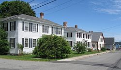
 Eastport, Boynton Street |
||
| Location in Maine | ||
|
|
||
| Basic data | ||
| Foundation : | February 24, 1798 | |
| State : | United States | |
| State : | Maine | |
| County : | Washington County | |
| Coordinates : | 44 ° 55 ′ N , 67 ° 0 ′ W | |
| Time zone : | Eastern ( UTC − 5 / −4 ) | |
| Residents : | 1,331 (as of 2010) | |
| Population density : | 140.1 inhabitants per km 2 | |
| Area : | 31.2 km 2 (approx. 12 mi 2 ) of which 9.5 km 2 (approx. 4 mi 2 ) is land |
|
| Height : | 32 m | |
| Postal code : | 04631 | |
| Area code : | +1 207 | |
| FIPS : | 23-21730 | |
| GNIS ID : | 0565748 | |
| Website : | www.eastport-me.gov | |
Eastport is located in Washington County in the US state of Maine . The city is the easternmost city in the United States . The city borders on New Brunswick ( Canada ).
Old Sow
Eastport is known, among other things, for the Old Sow, a natural tidal vortex located off the coast with a diameter of around 75 meters, the largest of its kind in the western hemisphere.
Easternmost point of the USA
The most easterly point in the United States, station PD1179, is on the parish pier at 44 ° 54'16.27257 "north, 66 ° 59'0.71006" west.
population
93.6 percent of the population are white, 0.4 percent African American, 4.0 percent Native American, and 0.9 percent Hispanic American. The annual per capita income is $ 14,864. 17.2 percent of the population lives below the poverty line.
history
Most of the approximately 1,600 residents reside on Moose Island, which is connected to the mainland by a dam and has been settled by settlers from Newburyport ( Massachusetts ) and Portsmouth ( New Hampshire ) since 1782 . The settlement was declared a town as early as 1798 . To prevent the widespread smuggling with Canada, Fort Sullivan was built in 1807, but this fort surrendered to an English squadron under Sir Thomas Hardy on July 11, 1814 in the war of 1812 . After the peace treaty, Eastport fell back to the United States in 1818, but the controversial border in Passamaquoddy Bay was initialed in the Webster-Ashburton Treaty of 1842. On March 18, 1893, Eastport was declared a city .
Even today, agriculture and fishing are the most important industries of the place, the sardine industry , which was important in the course of the 19th century , in which up to 800 people found a livelihood in 13 processing plants, is of no importance today due to overfishing . Tourism, which is promoted by the summer operation of a ferry to Deer Island in New Brunswick , is of growing importance.


