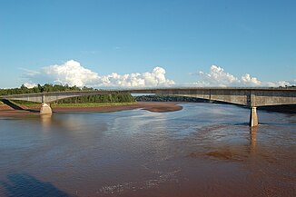
Shubenacadie River
| Shubenacadie River | ||
|
Bridge over the Shubenacadie River near South Maitland |
||
| Data | ||
| location | Halifax Regional Municipality , Hants County , Colchester County , Nova Scotia, Canada | |
| River system | Shubenacadie River | |
| origin |
Shubenacadie Grand Lake 44 ° 55 ′ 35 ″ N , 63 ° 34 ′ 19 ″ W. |
|
| Source height | 13 m | |
| muzzle |
Cobequid Bay ( Bay of Fundy ) coordinates: 45 ° 18 ′ 58 " N , 63 ° 29 ′ 3" W 45 ° 18 ′ 58 " N , 63 ° 29 ′ 3" W. |
|
| Mouth height | 0 m | |
| Height difference | 13 m | |
| Bottom slope | 0.18 ‰ | |
| length | 72 km | |
| Discharge at the Enfield gauge ( ⊙ ) A Eo : 389 km²
|
MQ 1975/1994 Mq 1975/1994 |
12.6 m³ / s 32.4 l / (s km²) |
| Left tributaries | Nine Mile River | |
| Right tributaries | St. Andrews River , Stewiacke River | |
| Communities | Enfield , Shubenacadie | |
The Shubenacadie River is a river in the Canadian province of Nova Scotia .
The Shubenacadie River forms the drain of Shubenacadie Grand Lake - 30 km north of Halifax . It meanders in a northerly direction past Enfield and Shubenacadie and flows into Cobequid Bay at Maitland , which is the northern part of the Minas Basin . The tides are noticeable in the lower 30 km of the river . Twice a day a tidal wave up to 3 m high flows upstream.
Local tourism companies offer rafting and boat tours on the tidal river. Tributaries are the Nine Mile River from the left, and the St. Andrews River and Stewiacke River from the right. The Shubenacadie River is 72 km long. The Shubenacadie Canal runs from Halifax Harbor to Shubenacadie Grand Lake.
Web links
Individual evidence
- ↑ Water Survey of Canada - Station 01DG006 ( Memento of the original from December 24, 2010) Info: The archive link was automatically inserted and not yet checked. Please check the original and archive link according to the instructions and then remove this notice.
