Bicom strips
The bikomi strip on the border with today's East Timor
|

|

|
|
|
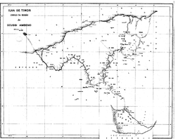
Maps by Oe-Cusse Ambeno (1914). On the left map are the Bikomi Strip and Noimuti southeast of Oe-Cusse Ambeno. On the right map, the disputed territories between Portugal and the Netherlands on Timor are shown in red. The bicomi stripe extends from Noimuti to the line between A and D.
|
||
The Bicomi Strip (also Bicomicorridor or Bicome ) was a small territory between the then exclaves Portuguese Timors Oe-Cusse Ambeno and Noimuti in the west of the island of Timor . The strip was named after the kingdom of Bikomi .
history
The traditional rulers of Oe-Cusse Ambeno claimed the area to establish a land link between Oe-Cusse Ambeno and Noimuti. However, through the Treaty of Paravicini , the Netherlands claimed sovereignty over the area. In the 1904 treaty, Portugal assured the Netherlands that it would acquire Noimuti and the Bikomi Strip as soon as the boundaries of Oe-Cusse Ambeno were defined. In 1913 the Permanent Court of Arbitration in The Hague was finally called upon to make a decision on the definitive demarcation of the boundary. In 1916 the final contract was signed in which Noimuti and the Bikomi Strip went to the Netherlands.
Today the area of the Bikomi Strip belongs to the Indonesian administrative district ( Kabupaten ) of North Central Timor .
Individual evidence
- ↑ Laura Suzanne Meitzner Yoder: Custom, Codification, Collaboration: Integrating the Legacies of Land and Forest Authorities in Oecusse Enclave, East Timor, pp. 84 ff., Dissertation, Yale University, 2005 ( PDF file; 1.46 MB ( Memento of March 7, 2007 in the Internet Archive )).
Coordinates: 9 ° 28 ′ 45.9 ″ S , 124 ° 24 ′ 37.2 ″ E
