
Biniaiet Vell
| Biniaiet Vell Poblat Talaiotic de Biniaiet Vell | |||
|---|---|---|---|
 |
|||
Location in Menorca |
|||
| Coordinates | 39 ° 54 '11 " N , 4 ° 12' 15" E | ||
| place | Maó , Balearic Islands , Spain | ||
| Emergence | 1st millennium BC Chr. | ||
| Dimensions | 200 m | ||
| height | 110 m | ||

Biniaiet Vell (full name Poblat Talaiòtic de Biniaiet Vell , "Talayotic settlement of Biniaiet Vell") is an archaeological site on the Spanish Balearic island of Menorca . The settlement, which is assigned to the Iron Age talayot culture , is located on the border between the municipalities of Maó and Alaior in the east of the island. Biniaiet Vell was considered to be one of the best preserved prehistoric sites on the island until the early 20th century, but was badly damaged in the course of road construction in 1918.
location
Biniaiet Vell is located about 5.5 kilometers west of the city center of Maó immediately north of the island's main road ME-1 to Ciutadella . On a narrow asphalt road that branches off to the north 100 meters before the municipality boundary with Alaior, there is a small parking lot after 300 meters. This is available to visitors to the Biniaiet Vell sites in the municipality of Maó and Sant Vicenç d'Alcaidús in the municipality of Alaior. Both sites belonged to the same settlement in Talayotic times, but are now separated by the asphalt road and the municipal boundaries. Two display boards provide brief information on both archaeological sites, which can be freely accessed at any time. Biniaiet Vell is to the right of the road on a small hill 110 m above sea level. The hypogea of Biniai Nou is only about 800 meters to the northeast .
history
Biniaiet Vell experienced its heyday in the 1st millennium BC. The talayots - tower-like structures that gave the culture on Mallorca and Menorca its name - were built from 850 BC. The round houses date from the second half of the 1st millennium, when the talayots had already been abandoned.
The interested general public became aware of the settlement in 1818 through the Menorcan historian Joan Ramis i Ramis (1746-1819), who mentioned it in his book Antigüedades célticas de la Isla de Menorca desde los tiempos más remotos hasta el siglo IV de la era cristiana . In 1916, Antonio Vives Escudero (1859–1925) and Francesc Hernández Sanz (1863–1949) carried out one of the first archaeological excavations on Menorca here. The government-funded work concentrated on the area southeast of the central talayot and on two smaller areas north and west of this structure. Several post-Talayotic houses were excavated. Partial results were published in 1973 by Joan Hernández Mora (1902-1984), the son of Francesc Hernández Sanz, and Josep Mascaró Pasarius . In addition to ceramic shards from the 5th to 1st century BC Mainly stone mortars and grinding stones were found. As early as the 1960s, Maria Lluïsa Serra Belabre (1911–1967) identified prehistoric quarries near the site in which the material for building the settlement had been extracted.
In 1918, the Biniaiet Vell site was used as a quarry to repair the island road between Maó and Ciutadella . The central talayot and other building structures were destroyed.
Biniaiet Vell stands since 1966 under monument protection and is in the Spanish Database of Cultural Assets ( Bienes de Interés Cultural ) under the number RI-51-0003520 as Monumento registered. Biniaiet Vell was not considered in the selection of 25 sites that were jointly placed on the Spanish tentative list in 2013 as “ Talayotic culture of Menorca ” for the award of the title “ UNESCO World Heritage Site ”.
description
overview
Although parts of the site were destroyed in 1918, parts of a wall as well as numerous columns and pilasters as remains of post-Talayotic round houses ( cercles ) can be found between the two surviving talayots . However, they are in a significantly worse state of preservation than in neighboring Sant Vicenç d'Alcaidús.
The talayots
The round northern talayot represents the highest point of the settlement. It is surrounded by a modern dry stone wall, over which it can also be climbed. At its top there is a brick surveying pillar that marks the municipal boundary between Maó and Alaior. The southern talayot is about 200 m to the southwest. Like its northern counterpart, it is in a poor state of preservation, but offers a spectacular view of the southeast of Menorca from Alaior via Sant Climent to Maó. The central talayot, which was removed in 1918, is only marked by a group of olive trees .
The flats
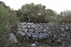
In the entire area between the two talayots are the remains of post-Talayotic houses (cercles). These residential buildings, typical of Menorca, often had an approximately circular floor plan and were bordered by double walls made of large, upright stone slabs. Around an inner courtyard with a fireplace stood pillars on which simple dry stone walls were attached and divided several rooms. Already on the way from the parking lot you come across numerous upright stone blocks. However, only three houses near the central talayot that were excavated in 1916 have been scientifically investigated. The names house 1, house 2 and house 3 go back to Lluís Plantalamor Massanet (* 1949).
House 1 is north of the former central talayot and was probably built directly on its outer wall. Its double-walled wall consists of large vertically standing blocks on the outside and horizontal stones on the inside. Only one room of 5.50 mx 3.00 m in size remains, which is reached from the north via a 3 meter long corridor and entered from the east. The outer diameter of the complete round house should once have been 12 m.
House 2 leaned against the central talayot in the southwest. It is built similarly to a round house, but has an irregular floor plan, apparently dictated by the subsurface, with one or two courtyards and perhaps two entrances. Its extension is 23.5 m in north-south direction, 18 m in east-west direction, and the usable area is 141.5 m². It is estimated that the house was inhabited by 34 to 35 people.
House 3 adjoins House 2 in the southwest. Its floor plan roughly corresponds to the letter "L". It extends 13 m in north-south direction and 11.3 m in east-west direction. The living space was 68.5 m², enough for 16 to 17 residents. The house was entered from the south. A small corridor is followed by an inner courtyard with the fireplace in the northeast. There are two rooms to the north and west of the courtyard, with the largest room in the north-west measuring 4.50 m × 5.50 m.
- Views from Biniaiet Vell
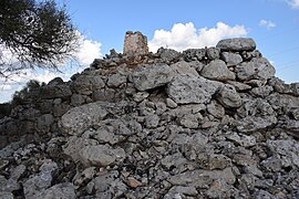
northern talayot

southern talayot

House 3

a not yet excavated round house
Wall


Individual evidence
- ^ Antoni Nicolau Martí, Elena Sintes Olives, Ricard Pla Boada, Albert Àlvarez Marsal: Talayotic Minorca . The prehistory of the island. Triangle Books, Sant Lluís 2015, ISBN 978-84-8478-640-5 , pp. 124-127 (English).
- ↑ a b c d e f g Joaquim Pons Machado: Caracterització de l'espai de l'hàbitat protohistòric de l'illa de Menorca: les cases de planta circular talaiòtiques . Dissertation Universitat Autònoma de Barcelona 2016, ISBN 978-84-490-6731-0 , pp. 55–60 ( full text online PDF, 250 pages in 4 files, Catalan).
- ^ Joan Ramis i Ramis: Antigüedades célticas de la Isla de Menorca desde los tiempos más remotos hasta el siglo IV de la era cristiana . Imprenta de Pedro Antonio Serra, Maó 1818, p. 14 ( full text online , Spanish).
- ↑ Information board at the site, seen on September 29, 2016
- ↑ Cultural heritage database at the Spanish Ministry of Education, Culture and Sport (note: search for "Biniaiet"), accessed on December 7, 2017.
- ^ Talayotic Culture of Minorca , on the Spanish tentative list at UNESCO, accessed on December 1, 2017.
- ↑ Ll. Plantalamor Massanet: L'arquitectura prehistórica i protohistòrica de Menorca i el seu marc cultural . Trcballs del Museu de Menorca, n ° 12, ed. Conselleria d'Educació i Cultura del Govern Balear, Maó 1991 (Catalan).
- ↑ a b c Joaquim Pons Machado: Caracterització de l'espai de l'hàbitat protohistòric de l'illa de Menorca: les cases de planta circular talaiòtiques . Dissertation Universitat Autònoma de Barcelona 2016, ISBN 978-84-490-6731-0 , Annex 2, pp. 21–26 ( full text online PDF, 250 pages in 4 files, Catalan).