Birdsville Track
| Birdsville Track | |||||||||||||||||||||||||||||||||||||||||||
|---|---|---|---|---|---|---|---|---|---|---|---|---|---|---|---|---|---|---|---|---|---|---|---|---|---|---|---|---|---|---|---|---|---|---|---|---|---|---|---|---|---|---|---|
| map | |||||||||||||||||||||||||||||||||||||||||||
| Basic data | |||||||||||||||||||||||||||||||||||||||||||
| Operator: | Transport SA | ||||||||||||||||||||||||||||||||||||||||||
| further operator: | Dept. of Transport and Main Roads | ||||||||||||||||||||||||||||||||||||||||||
| Start of the street: |
D95 Oodnadatta Track Marree ( SA ) ( 29 ° 39 ′ S , 138 ° 4 ′ E ) |
||||||||||||||||||||||||||||||||||||||||||
| End of street: |
Birdsville ( QLD ) ( 25 ° 55 ′ S , 139 ° 23 ′ E ) |
||||||||||||||||||||||||||||||||||||||||||
| Overall length: | 517 km | ||||||||||||||||||||||||||||||||||||||||||
|
States : |
|||||||||||||||||||||||||||||||||||||||||||
| Development condition: | unpaved | ||||||||||||||||||||||||||||||||||||||||||
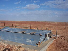
| MV Tom Brennan Memorial | |||||||||||||||||||||||||||||||||||||||||||
|
Course of the road
|
|||||||||||||||||||||||||||||||||||||||||||
The Birdsville Track is a dirt road in the Australian outback . The road is 517 kilometers long and connects the South Australian town of Marree with Birdsville in southern Queensland . The road crosses the Tirari Desert , the Sturts Stony Desert and the Strzelecki Desert .
history
The road was built in the 1860s to allow cattle to be driven from northern Queensland and the Northern Territory to the nearest rail links at Port Augusta and later Marree . Soon the track also became an important route for the mail to remote locations and farms.
Until the 1930s, the road was only passable for cattle drives and camel caravans. These days the route is maintained regularly and is considered to be easily navigable, but the passage can be problematic, especially after rain. Mungeranie , a hamlet of three inhabitants 204 kilometers north of Marree, is the only place where vehicles can be refueled.
course
In Marree , the Birdsville Track branches off from the Oodnadatta Track (D95) to the north-northeast. The Birdsville Track crosses the dingo fence between the ruins of the Lake Harry settlement on the salt lake of the same name and Clayton . Further north, at Etadunna , it crosses Cooper Creek and then leads north through the Tirari Desert. There is also Mungeranie , where a 51 km long cul-de-sac branches off to the northwest to Kalamurina and the only refueling facility on the way to Birdsville is.
The trail continues through the Sturts Stony Desert to Clifton Hills on Warburton Creek . Shortly before reaching the settlement, the Warburton Track turns west into the Simpson Desert . From Clifton Hills, the road curves widely to the east and then north around the impassable Goyder Lagoon and through the Strzelecki Desert. Almost at its most easterly point, the Walkers Crossing Road branches off to the south , a dirt road towards Innamincka . Pandie Pandie at the north end of Goyder Lagoon is the last parish on the territory of South Australia. Approx. 10 km after crossing the Queensland border, the Birdsville Track ends in Birdsville .
The highest point along the highway is 51 m, the lowest is 27 m.
The Back of Beyond
The 1954 production The Back of Beyond by the Australian documentary film pioneer John Heyer describes the Birdsville Track in an impressive way using the post driver Tom Kruse (1914–2011) who has become legendary. A 2001 re-enactment on Australian television with the still-living Kruse titled Last Mail from Birdsville was also a huge hit.
Web links
- Overview map of the Birdsville Track
- Birdsville Track - Info and Route (German)
- Video (2.2mb) about the Simpson desert
Individual evidence
- ^ A b Steve Parish: Australian Touring Atlas . Steve Parish Publishing, Archerfield QLD 2007. ISBN 978-1-74193-232-4 . P. 73
- ↑ maps.bonzle.com - Birdsville Track . Retrieved April 19, 2012.
- ↑ The Back of Beyond in the Internet Movie Database (English)
- ↑ Tom Kruse's story
- ↑ Last Mail from Birdsville in the Internet Movie Database (English)

