
Blaich (Scotland)
|
Blaich Scottish Gaelic Blàthaich |
|||
|---|---|---|---|
| Coordinates | 56 ° 51 ′ N , 5 ° 12 ′ W | ||
| OS National Grid | NN049771 | ||
|
|||
| administration | |||
| ZIP code section | PH33 7 | ||
| Part of the country | Scotland | ||
| Council area | Highland | ||
| British Parliament | Ross, Skye and Lochaber | ||
| Scottish Parliament | Skye, Lochaber and Badenoch | ||

Blaich is a small town on the south bank of Loch Eil . Created by Croftern , the Ordnance Survey map of 1875 showed 80 covered houses, compared to 33 on the current map from 1975. A hut from 1817 that has been converted into a church jointly owned by the Free Church of Scotland and the Church of Scotland has been in decline for about 20 years.
photos

Houses and agricultural land in Blaich
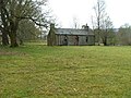
The former church in 2007 (without a roof since 2013)

View of the hole from the site


Web links
Commons : Blaich - collection of images
Individual evidence
- ↑ Blaich. In: canmore.org.uk. Historic Environment Scotland , 2017, accessed September 11, 2017 .
- ↑ Blaich. In: canmore.org.uk. Historic Environment Scotland , 2017, accessed September 11, 2017 .
- ^ Blaich Church of Scotland (Former), Blaich. In: buildingsatrisk.org.uk. September 23, 2013, accessed on September 11, 2017 .