Blue Mountains (Niger)
| Blue mountains | ||
|---|---|---|
| location | Agadez , Niger | |
| part of | Aïr | |
|
|
||
| Coordinates | 19 ° 35 ' N , 9 ° 12' E | |
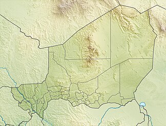
The Blue Mountains ( French : Montagnes Bleues , Tuareg : Izouzadene or Izouzaoenehe ) are up to 921 m high foothills of the Aïr in Niger , which is about 30 km east-northeast of the town of Iférouane .
geography
The Blue Mountains are located on the eastern edge of the Aïr high mountains in the Ténéré desert . Administratively, they belong to the Iférouane department and are part of the UNESCO World Heritage Aïr and Ténéré nature reserve . They are also located in an Addax reserve.
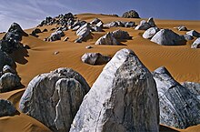
The characteristic Cipollino blocks of the Blue Mountains were created from marine limestone under high pressure and high temperatures . Their bluish shimmer against the orange desert sand gave the mountains its name. The shimmer is caused by shares of different minerals, including mica and serpentine , as well as by a refraction of the light in the crystalline structure of the rock and a selective reflection of the blue light component.
Individual evidence
- ^ Réserves naturelles de l'Aïr et du Ténéré. Carte des limites de la reserve (en vert). UNESCO Center du patrimoine mondial, accessed March 19, 2013 .
- ↑ Dominique Auzias, Jean-Paul Labourdette: Niger . Petit Futé, Paris 2009, ISBN 978-2-7469-1640-1 , pp. 8 .
- ↑ Dominique Auzias, Jean-Paul Labourdette: Niger . Petit Futé, Paris 2009, ISBN 978-2-7469-1640-1 , pp. 187 .
- ↑ Harald A. Friedl: The justifiability of ethnotourism using the example of the Tuareg of the Agadez region, Republic of Niger (West Africa) - An evaluation from the perspective of applied tourism ethics. Dissertation . Karl Franzens University Graz, Graz 2005, p. 219 .

