Iferouane
| Iferouane rural parish | ||
|---|---|---|
|
|
||
| Coordinates | 19 ° 4 ′ N , 8 ° 25 ′ E | |
| Basic data | ||
| Country | Niger | |
| Agadez | ||
| department | Iférouane | |
| ISO 3166-2 | NE-1 | |
| Residents | 13,655 (2012) | |
Iferouane (also: Iférouane , Iferouâne ) is a rural municipality and the capital of the Iférouane department in Niger .
geography

The municipality is divided into three administrative villages, two traditional villages, four camps and 22 water points. The main town of the rural parish is the administrative village of Iferouane. Iferouane is the main administrative seat of the Aïr and Ténéré nature reserve , the largest protected area in Africa with 77,000 km².
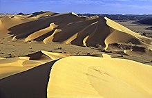
Iferouane is the main oasis in the northwestern part of the Aïr Mountains. The settlement is located in the Irhazar Valley (also: Ighazar Valley). The environment is very mountainous and rough. Quartz , granite and gneiss rocks shape the area. Most of them are loosely scattered, occasionally in large block formations. The small, quiet place lies at the foot of the Tamgak massif, which is up to 1988 meters high (a circular granite pluton and part of the vast Aïr Mountains) and is characterized by mud houses, mat tents and gardens. The German African explorer Heinrich Barth visited Iferouane in the 1850s, where not only date trees but, to his surprise, gardens caught his eye. Towards the end of the 19th century, the principle common throughout Yemen today was introduced that draft animals (usually an ox) pull a leather scoop over a roller from the well. The water is led to the beds via a canal system. The settlement of Tintellust , which was particularly important in the 19th century, belongs to the municipality . The neighboring communities of Iferouanes are Gougaram in the north, Djado , Dirkou and Fachi in the east, Assodé and Timia in the south and Dannet in the west.
history
The noble Kel-Ferwan- Tuareg , who have meanwhile migrated to the Agadez area, are considered to be the town's founding fathers . The name of the oasis place is derived from the Tamascheq and means in the language of the Tuareg settled there: "the fields".

In 1899 a French military expedition, the Foureau-Lamy mission , spent several months in Iferouane. In February of that year, additional pack animals were to be brought in here so that the arduous onward journey to Agadez could be covered. The expedition was only able to actually set off after a considerable delay, namely in June. Tuareg nomads had torpedoed the expedition's venture with a large number of attacks, so that a departure was out of the question. In addition, the promised pack animals were not delivered, so that the expedition leaders had to stock up on supplies on their own. At the same time, many of the camels they brought with them died. The expedition set out in June under the most difficult conditions. During the French colonial era, Iferouane was the northernmost military post in Niger. In 1947, the French administration set up a school specially for the nomadic population.
1964 an administrative reform divided Niger into seven departments, the predecessors of the later regions, and 32 arrondissements, the predecessors of the later departments. Iferouane was added to the newly created arrondissement Agadez, but received - like Ingall - the status of an administrative post ( poste administratif ) in the area of the arrondissement. Administrative posts were special territorial units one level below the arrondissements, which were regarded as a kind of preliminary stage for a later conversion into a separate arrondissement. The area of the Arrondissement Agadez was divided into the Arrondissements Arlit and Tchirozérine in 1969 . Iferouane was added to the Arlit arrondissement. In 1998, the previous Arrondissements of Nigers were converted into departments.
In the mid-1970s, the German Society for Technical Cooperation and the Society for Sewage Treatment Plants and Water Supply from Mannheim realized a large joint project to improve the water supply in the village. The number of gardens increased from 32 in 1981 to 81 in 1983/1984. In 1984, 1985 and 1986 the Dakar Rally passed through Iferouane.
During the 3rd Tuareg Rebellion (2007-2009) Iferouane was the opening scene of the rebellion through the first attacks of the MNJ . Numerous clashes between rebels and government troops rocked the region in and around Iferouane. In October 2007 the President of the SOS Iférouane Initiative announced that the uprising had caused weeks of starvation in the village because the supply lines were cut off. In addition, there was massive malaria and diarrhea . The shortage of water and harassment from the army made the situation even worse. In November 2008 it was found that the city was empty and no one lived there anymore. A wave of people fleeing to Arlit and Agadez was responsible for this. In 2009, however, most of the residents had returned. Since then, the destroyed infrastructures have been restructured and agriculture reactivated. Since 2011, the rural community no longer belongs to the Arlit department, but to the newly created Iférouane department. The previous administrative post was raised to the capital of the department.
population
In 1964 around 10,000 people lived in the area around Iferouane. At the 2001 census, Iferouane had 8,108 inhabitants, including 1918 in the administrative village of Iferouane. At the 2012 census, the population was 13,655. In the community which is Tamascheq - variety Tayart spoken.
Culture and sights
Visits to the prehistoric finds in the Aïr are mostly planned from Iferouane. To the north of the settlement are Neolithic rock paintings. Giraffes, cattle and antelopes clearly adorn boulders and noses. As far as Tezirek , 90 km away , you can always discover rock paintings.
In Iferouane, the Aïr Festival took place every year from December 27th to 29th from 2001 to 2006 until it moved to Tchirozérine . The region tries to make itself culturally strong for tourism. On the occasion of this festival, the Tuareg try to combine the useful and the social, because problems and possible assistance for the Tuareg are discussed. Competitions are also held. There are prizes to be won for the most beautiful day 's must , the best harnessed camel, the most beautiful traditional costume and other competition items. Dance, poetry, music and colorful presentations by the various festival delegations round off the three-day festival.
Economy and Infrastructure
The oasis is connected to the connecting road between Arlit and Agadez via unpaved roads and slopes, the economic center in traditional trade and handicrafts and a meeting point for long-distance caravan trade of the Saharan peoples and tribes. Iferouane has a civil airport with an unpaved runway, Iférouane Airport ( ICAO code : DRZI). In the main town there is a local radio communautaire .
Personalities
- Illias Almahady (* 1944), officer
- Brigi Rafini (* 1953), politician, Prime Minister Niger
See also
literature
- Maximilien Bruggmann / Hans Ritter: Ténéré (Through the southern Sahara) . Verlag CJ Bucher, ISBN 3-7658-1078-9 .
- Gerd Spittler : Droughts, war and hunger crises among the Kel Ewey (1900–1985). Stuttgart: Franz Steiner, 1989 (monograph).
- Heinrich Barth : 1857–1858: Travels and discoveries in North and Central Africa in the years 1849–1855, 5 volumes, Gotha 1855–1858 (reprint Saarbrücken 2005: Bd. 1 ISBN 3-927688-24-X , Bd. 2: ISBN 3-927688-26-6 , vol. 3: ISBN 3-927688-27-4 , vol. 4: ISBN 3-927688-28-2 , vol. 5: ISBN 3-927688-29-0 ; Abridged version as: In the saddle through North and Central Africa. 1849–1855, Stuttgart 2003, ISBN 3-86503-253-2 ).
Web links
Individual evidence
- ↑ Répertoire National des Communes (RENACOM) ( Memento of the original from January 9, 2017 in the Internet Archive ) Info: The archive link has been inserted automatically and has not yet been checked. Please check the original and archive link according to the instructions and then remove this notice. . Institut National de la Statistique website, accessed November 8, 2010.
- ^ Republic of Niger: Loi n ° 2002-014 du 11 JUIN 2002 portant création des communes et fixant le nom de leurs chefs-lieux .
- ^ Scottish geographical magazine , Volume 17 , accessed June 19, 2011.
- ^ Heinrich Barth, Reisen und Entdeckungen in Nord- und Central-Afrika in the years 1849–1855, Volume 1, p. 351; 425; 580 (see lit.)
- ↑ Gerd Spittler , Dürren, Krieg und Hungerkrisen, p. 7 ff. (See lit.)
- ↑ Fergus Fleming: The Sword and the Cross: Two Men and an Empire of Sand , accessed June 19, 2011.
- ^ JSTOR: The Geographical Journal, Vol. 71, No. 6 (June 1928) , accessed June 19, 2011.
- ↑ Conference Régionale sur la Problématique de l'éducation en milieu nomade dans l'espace sahélo-saharians. (PDF) (No longer available online.) SE SDS Sahel Niger, 2013, p. 2 , archived from the original on January 7, 2015 ; Retrieved January 7, 2015 (French). Info: The archive link was inserted automatically and has not yet been checked. Please check the original and archive link according to the instructions and then remove this notice.
- ↑ Edmond Séré de Rivières: Histoire du Niger . Berger-Levrault, Paris 1965, p. 275.
- ↑ Aboubacar Adamou: Agadez et sa Région (= Études Nigériennes . No. 44 ). Pr. De Copédith, Paris 1979, p. 2 .
- ↑ Historique de la decentralization. (No longer available online.) ANIYA. Réseau des collectivités nigériennes et françaises, archived from the original on April 6, 2012 ; Retrieved January 28, 2014 (French).
- ^ Frederick E. Brusberg: Economy and society of Aoudéras, a community of the Saharan Aïr Massif (Niger) . Dissertation. McGill University, Montreal 1988, pp. 83 ( digitool.library.mcgill.ca [PDF; accessed on May 11, 2018]).
- ↑ Dakar Retrospective 1979–2007. (PDF) (No longer available online.) Amaury Sport Organization, archived from the original on July 8, 2011 ; accessed on February 14, 2018 (English).
- ^ Tuareg Rebels Gathering Strength in Niger , accessed June 19, 2011.
- ↑ NIGER: Humanitarian crisis feared in north , accessed on 19 June 2011th
- ↑ Niger raids leaves 'ghost town' , accessed June 19, 2011.
- ↑ Niger: Lull in conflict favors return in the north ( Memento of the original from January 30, 2010 in the Internet Archive ) Info: The archive link was inserted automatically and has not yet been checked. Please check the original and archive link according to the instructions and then remove this notice. , accessed June 19, 2011.
- ↑ Une nouvelle loi sur le redécoupage administratif . In: L'Arbre à Palabres . No. 13 , August 11, 2011, p. 2 ( nigerdiaspora.net [PDF; accessed on January 28, 2014]).
- ↑ JSTOR: The Geographical Journal , Vol. 62, No. 1 (January 1972) , accessed June 19, 2011.
- ^ Institut Nationale de la Statistique du Niger (ed.): Annuaire statistique des cinquante ans d'indépendance du Niger . Niamey 2010 ( online version ; PDF; 3.1 MB), p. 53.
- ↑ Presentation of the result globaux définitifs du Quatrième (4ème) Recensement Général de la Population et de l'Habitat (RGP / H) de 2012. (PDF) Institut National de la Statistique, 2014, accessed on April 18, 2014 (French).
- ↑ Niger map. In: Ethnologue: Languages of the World. Seventeenth edition. SIL International, 2013, accessed July 18, 2013 .
- ↑ Jim Hudgens, Richard Trillo The rough guide to West Africa , accessed June 19, 2011.
- ↑ Jolijn Geels, Niger: The Bradt Travel Guide , accessed June 19, 2011.
- ↑ Airports in Niger . Aircraft Charter World website, accessed January 23, 2012.
- ↑ La situation de la communication pour le développement au Niger (Etat des lieux). Tome 1. (PDF; 461 kB) Food and Agriculture Organization of the United Nations, 2003, p. 117 , accessed on November 1, 2019 (French).


