Blum Basin Falls
| Blum Basin Falls | ||
|---|---|---|
| Coordinates | 48 ° 44 '1.25 " N , 121 ° 30' 9.47" W | |
|
|
||
| place | North Cascades National Park , Whatcom County , Washington | |
| height | 510 m | |
| width | 3 m | |
| Number of fall levels | > 3 | |
| Falling watercourse | Blum Creek | |
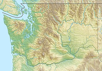
The Blum Basin Falls are waterfalls in Whatcom County , Washington State . They are located in the North Cascades National Park in the headwaters of Blum Creek , a tributary of the Baker River , at an altitude of 1,710 meters. The falls, fed by two receding glaciers and several snowfields on the south side of Mount Blum , are part of the largest meltwater stream that flows into Blum Creek. The falls thunder down over 1,680 ft (512 m) in two stages, the highest of which is about 900 ft (274 m), from the back wall of a kar valley; the first stage is a series of rapids over rounded rocks above the tree line , the second stage is a series of almost vertical gullies into the wooded valley below. Although most of it is clearly visible, some areas are obscured by tall pine trees that grow at the base of the falls. There is no hiking trail to the falls.
etymology
The falls are named after the creek, which in turn is named after Mount Blum, which in turn was named after John Blum, a fire watch pilot for the United States Forest Service who was killed in an aircraft accident in the early 20th century.
statistics
The height of the cascade series is 1,680 ft (512 m), but this has never been officially measured. The length of the falls, the length of Blum Creek as a waterfall, is 1,500 ft (457 m), but this size is only an estimate. During peak runoff, when high temperatures accelerate the melting of ice and snow in the upper catchment area, up to 2.8 m³ / s can be measured with an average width of the falls of three meters. In contrast, melting subsides at low winter temperatures, so that the cases show only minimal or no runoff. According to the World Waterfall Database, the Blum Creek Falls 2009 ranked 84th in terms of height.
History and access
The first documented sighting of the cases was in 1920 by Pacific Northwest photographer Asahel Curtis , who photographed the cases. Because Mount Blum had not yet been named, both the stream and the waterfalls were unknown and unnamed and until then remained largely hidden. Today the Baker River Trail runs several miles upstream of the Baker River, and when it crosses Blum Creek one can get a glimpse of the upper part of the falls. The falls are also visible from part of the Shuksan Lakes Trail, which leads up Mount Shuksan on the opposite side of the Baker River Valley. Better views are possible from this trail. However, the falls are not the prettiest in the area. The better known Sulphide Creek Falls are close by and the Blum Basin Falls remain unknown to most visitors to the area.
Individual evidence
- ↑ Mount Blum . SummitPost. Retrieved May 18, 2009.
- ↑ a b Bryan Swan: Blum Basin Falls . Waterfalls of the Pacific Northwest. Retrieved May 18, 2009.
- ↑ World's Tallest Waterfalls . World Waterfall Database. Retrieved May 18, 2009. World's Tallest Waterfalls. (No longer available online.) Archived from the original on July 12, 2011 ; accessed on May 17, 2018 . Info: The archive link was inserted automatically and has not yet been checked. Please check the original and archive link according to the instructions and then remove this notice.
