
Blood Tower (Bern)

The Blood Tower ( Hexenturm, Harz Tower ) was the northern final link of the fourth western belt of the historic city fortifications of Bern .
history
The so-called blood tower , built around 1468 to 1470, is a semicircular defense tower originally open to the east with a length of nine meters, a width of 8.7 meters and a height (up to the roof) of 8.3 meters. In total, the tower is 15 meters high. The walls are evenly 2.1 meters thick. The blood tower was first depicted by the artist Hans Rudolf Manuel (1525–1571) in 1549 in his vedute of the city of Bern.
Johann Rudolf Gruner named the tower for the first time in a document in 1732 as a blood tower. The name Hexenthurm is from 1756 and the term Harzthurm is handed down in an official document from 1783 . From 1806 the Anatomical Institute used the blood tower to bleach skeletons, which repeatedly led to complaints from the population.
The Blood Tower has been under cantonal protection since 1908 and is a cultural asset of regional importance (Category B).
photos

West view (created between 1898 and 1907)
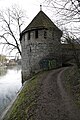
West view (2016)

View from the south with the dump wall (2011)

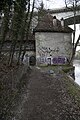
View from the southeast with the heap wall (2016)
View from the East (2016)


literature
- Urs Boschung ea: The anatomy in Bern from 1896/97. On the overall renovation 1984-88 , Bern 1988, p. 27.
- Johann Rudolf Gruner: Deliciae urbis Bernae. Merckworthiness of the hochlöbl. City of Bern. Compiled from mostly unprinted authentic writings , Zurich 1732. Digitized
- Paul Hofer: Die Kunstdenkmäler der Stadt Bern , Vol. 1, S. 174–175.
- Paul Hofer: The fortifications of Bern. Nydegg Castle and city fortifications from the 12th to the 19th century , Bern 1953, pp. 52–53.
- Heinrich Türler : About the towers and ring walls of the city of Bern . In: New Berner Taschenbuch on the year 1896, pp. 164–165. Digitized
See also
Web links
- Holdings in the burger library in Bern
Individual evidence
- ↑ See Wikimedia Commons .
- ↑ Gruner 1732, p. 444.
- ↑ Türler 1896, p. 164.
- ^ RRB of November 24, 1908.
- ↑ B objects BE 2018 . Canton of Bern KGS inventory, B objects, status: 2009, unadjusted (1.1.2018; municipal mergers for 2018 are marked in blue). In: babs.admin.ch / kulturgueterschutz.ch. Federal Office for Civil Protection FOCP - Department of Cultural Property Protection, January 1, 2018, p. 2, accessed on March 29, 2020 (PDF; 344 kB, updated annually, the changes for 2018 are marked in blue).
Coordinates: 46 ° 57 '8.4 " N , 7 ° 26' 36.1" E ; CH1903: 600359 / 200140