Boberger See
| Boberger See | ||
|---|---|---|

|
||
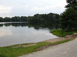
| Swimming area at Lake Boberger See | ||
| Geographical location | Hamburg-Lohbrügge , Germany | |
| Data | ||
| Coordinates | 53 ° 30 '53 " N , 10 ° 8' 9" E | |
|
|
||
| surface | 7.86 hectares | |
| length | 486 m | |
| width | 392 m | |
| volume | 301,000 m³ | |
| Maximum depth | 11.5 m | |
| Middle deep | 4.2 m | |
The Boberger See , also Boberger Baggersee or Boberger Kiessee , is an artificial lake in the nature reserve Boberger Niederung in Hamburg . It was created from around 1937 by dredging sand for the construction of the nearby Hamburg-Lübeck section of what was then the Reichsautobahn and later other structural measures on the Hamburg-Lübeck motorway section.
The lake is on average about 330 meters long and 170 meters wide, including individual bays and a long, narrow tip, the maximum dimensions are 486 meters in the northwest and 392 meters in the southwest. The area stated is 7.86 hectares , the greatest depth is about 11 meters.
To the north of the lake is the Boberg glider airfield , which extends 1.5 kilometers to the southeast. On the north-east side there is a small, general bathing beach; the south-western bank is mostly used by nudists . The Boberger See is leased by the Bergedorfer Angelverein from 1954 e. V.
Web links
Individual evidence
- ↑ a b c Bergedorfer Anglerverein , Gewässerüberblick, page 40
- ↑ Boberger Niederung nature reserve
