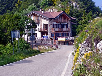
Bocca di Navene
| Bocca di Navene | |||
|---|---|---|---|
|
|
|||
| Compass direction | north | south | |
| Pass height | 1420 m slm | ||
| region | Trentino , Trentino-Alto Adige , Italy | Verona , Veneto , Italy | |
| Valley locations | Navene | ||
| expansion | Pass road | ||
| Mountains | Monte Baldo , Alps | ||
| map | |||
|
|
|||
| Coordinates | |||
The Bocca di Navene saddle ( 1420 m slm ) is the deepest cut in Monte Baldo .
geography
The saddle separates the Monte Altissimo di Nago ( 2078 m ) in the north from the rest of the group with the highest peak of the massif, the Cima Valdritta ( 2292 m ) in the south. On the eastern side of the saddle is the Lago di Prà della Stua reservoir .
Economy and Transport
There is a managed rifugio at the saddle . The Strada Provinciale del Monte Baldo, also known as Strada Graziani after the Italian General Andrea Graziani , leads directly over the saddle . Apart from directly via the country road, the saddle can be reached as a mountain hike from Navene , a district of Malcesine , located below on Lake Garda .

