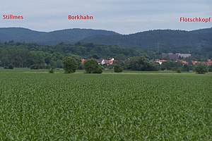
Borkhahn
| Borkhahn | ||
|---|---|---|
|
View from the east |
||
| height | 391.8 m above sea level HN | |
| location | Thuringia ( Germany ) | |
| Mountains | Richelsdorf Mountains | |
| Coordinates | 50 ° 59 '27 " N , 10 ° 2' 11" E | |
|
|
||
| rock | Red sandstone | |
The Borkhahn is a 391.7 m high, fully wooded elevation and is located in the Gerstunger Forest, a closed forest area of the municipality of Gerstungen in the Wartburg district in Thuringia . In terms of nature, the Borkhahn is part of the eastern part of the Solztrotten Forest in the Richelsdorf Mountains .
Today's field name "Borkhahn" is marked with "Vorderer Borkhahn", "Mittlerer Borkhahn" and "Hinterer Borkhahn" in the field maps. The original forest place name is not known, in the Urmes table sheet (mid-19th century) the mountain is still referred to as “black cock”, where a heather landscape is depicted. The Vitstrauchbach rises on the western slope of the mountain, the corridor there bears the name "Das Gebrannte" - whether as an indication of slash and burn or a naturally caused forest fire - cannot be decided. The Borkhahn located on the southern edge of the Gerstung Forest was reforested with pine and spruce in the late 19th century. During the GDR era, the Gerstung Forest was inaccessible in the restricted area.
Individual evidence
- ↑ Official topographic maps of Thuringia 1: 10,000. Wartburgkreis, district of Gotha, district-free city of Eisenach . In: Thuringian Land Survey Office (Hrsg.): CD-ROM series Top10 . CD 2. Erfurt 1999.

