
Boston Lake
|
Boston Lake (Possuteng, Baghrash, Bagrax) |
||
|---|---|---|
,_Xinjiang,_China,_87.00E,_42.00N.jpg)
|
||
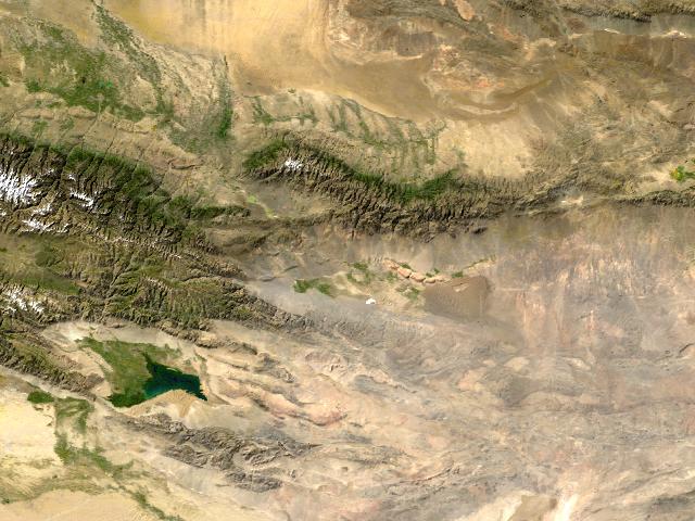
| Satellite image of Lake Bosten from November 2, 2004. View from south to north. | ||
| Geographical location | Circle Bohu County , Mongolian Autonomous Prefecture Bayingolin , Xinjiang , China | |
| Tributaries |
Kaidu Huangshui Qingshui and 10 others. |
|
| Drain | Konqi → Lop Nor desert | |
| Data | ||
| Coordinates | 42 ° 0 ′ N , 87 ° 0 ′ E | |
|
||
| Altitude above sea level | 1048 m | |
| surface | 1 019 km² | |
| length | 55 km | |
| width | 25 km | |
| volume | 7.74 km³ | |
| Maximum depth | 15.7 m | |
| Catchment area | 55,600 km² | |

The Boston Lake (also: Bagrax Hu ; Chinese 博斯滕 湖 , Pinyin Bósīténg Hú ; Uighur باغراش كۆلى Baghrash Koeli / Baƣrax Kɵli ) is 57 km northeast of the city Korla in circles Bohu County (Bohu博湖县) of the Mongolian Autonomous Prefecture Bayingolin the Uygur Autonomous Region of Xinjiang in Yanqi Basin 焉耆盆地 of the southeastern border area Tian Shan ( 天山 ). It is one of the largest freshwater inland lakes in China .
geography
The Bosten-See including several small secondary lakes covers an area of approx. 1000 km² (length 55 km, width 25 km). Its volume is approximately 7.7 km³. The lake is at an altitude of around 1048 m . A depth of up to 15.7 meters was measured, with the lake level fluctuating with the seasons and an overall increase in the water level is currently being recorded. There are various thermal springs in the eastern lake basin, but the lake is frozen over between November and March.
The Yanqi Basin, in which the lake is located, is bordered in the north by glaciated mountain ranges ( Sarmin , Chajdutau and Bortoula ranges ) over 4000 m high , in the south by the Kokteketau and Borochotan mountains as well as the Kuruk Tagh , which above 2500 m high.
In the northeast is the Turpan Depression , in the southwest the Tarim Basin .
The history of the lake
After taking a sample while drilling in the bedrock of Lake Bosten in 1957, the Russian engineer Jida suspected that the lake is 4,000 years old. Recent studies indicate that the lake could have formed around 8,000 years ago.
According to a report by the Chinese Li Daovuan with the title Shui Jin Zhu (2nd part) from the sixth century , instead of the lake there was only a swamp area at that time, which the Chinese called the following names: Su (= swamp with some water), Zhu (= small island in the water) or Pu (= water surface).
During the time of the Chinese Emperor Jiaqing (1798–1820) in the Qing Dynasty , Xu Song visited Lake Boston and measured it. The lake was then 138 km long and 23 km wide; the depth of the lake was 16 meters. It was surrounded by vast swamps.
Tributaries of the lake
Among the lake's various tributaries, the four largest are the Kaidu開 都 河, the Huang Shui Gou 黃 水溝, the Qing Shui 清水 河, and the Wu-La-Si-Te 烏拉 司 特 河. 96% of the lake water comes from these four rivers. The largest river, the Kaidu River 開 都 河, has a share of 83% of the river water. The Kaidu River carries water mainly in the summer months between May and September, namely groundwater and surface water mainly from precipitation and melt water from glaciers.
The lake and its meaning
Lake Bosten is of great importance for the region because of its rich fish stocks and as a wetland area of 1400 km². It is subject to fluctuations in the lake level and since its description by Sven Hedin at the beginning of March 1896 has greatly reduced its depth and scope. About 100,000 hectares of farmland in the Yanji Basin are irrigated by the water from the Bosten Lake and the Kaidu River. In addition, the lower reaches of the Tarim and the Daxihaizi reservoir located there receive a substantial part of their water inflow from the Bosten Lake via the Konqi (Kong Que 孔雀河 = peacock river). This will preserve a green corridor that protects the eastern road G218 which runs through the Tarim Basin塔里木盆地 and separates the Taklamakan Desert from the Kuruk Tag Desert in the Lop Nor Basin. Before the construction of extensive irrigation systems in the Yanji Basin, the Konqi was a major tributary of the now dried up Lop Nor羅布泊 Lake.
climate
The monthly mean temperature in January is −10 ° C and in July + 28 ° C. The annual mean temperature is 9.5 ° C.
The mean annual rainfall is 70 mm with an annual potential evaporation of 2000 mm.
Current developments
While at the end of the last century there were still fears that the lake would sink and become too salty, recent studies indicate a rise in the lake level. The reasons for the rise in water levels are assumed to be additional water due to increasing glacial melt and an increase in annual rainfall.
Etiological saga from Lake Bosten
According to an etiological legend, which aims to explain the origin of the name "Bosten Lake", there used to be no lake in the Yanji Basin, only a large steppe on which a young couple lived. The boy named Bosten loved the girl Gaya. But the rain spirit in the sky kidnapped the girl and tried to make Gaya his wife. Bosten defeated him, but he was so exhausted that he died. Gaya mourned and wept and wept. Her tears turned the steppe into a vast lake. In honor of this pair of lovers, the lake was named Bosten-See.
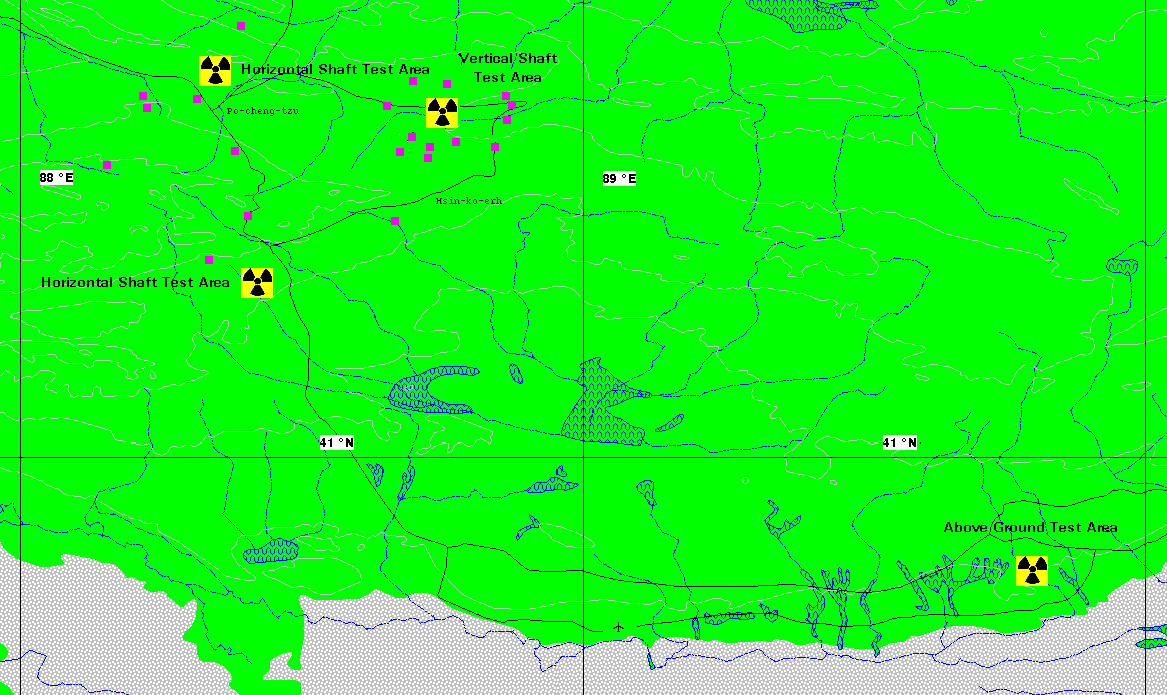
Chinese nuclear weapons test site
The Chinese nuclear weapons test site Lop Nor is located 100 km southeast of Lake Bosten . Between 1964 and 1996, a total of 45 above-ground (last on October 16, 1980) and underground nuclear weapon tests were carried out there. The nuclear weapons test site is intended as an interim storage facility and as a possible final storage facility for hot and highly radioactive waste .
literature
- Sven Hedin : The geographical-scientific results of my travels in Central Asia 1894–1897 (supplementary volume 28 to Petermanns Mitteilungen), Gotha 1900.
- Yuri Bregel: An Historical Atlas of Central Asia . Brill, Leiden 2003, ISBN 90-04-12321-0 .
Web links
The Boston lake
- Satellite map shows Lake Bosten with the northeast (including Turpan)
- Fluctuations in lake level at Lake Bosten (PDF; 1.5 MB)
- Interdisciplinary DFG bundle project on the topic: "Investigations into the sea history and microorganisms of the Boston Hu since the Young Cenozoic (NW China, Xinjiang Province)"
- data sheet
- Climatic variability in arid central Asia over the last 2000 years documented by Bosten Lake, China . (PDF; 312 kB)
- Stable isotopic variations in oxygen and hydrogen of waters in Lake Bosten region, Southern Xinjiang, Western China . (PDF; 312 kB) 2002.
The Yanqi Basin
- Philip Andreas Brunner: Yanqi Basin . (PDF) May 2003. Page 14ff.
- Philip Andreas Brunner: Water and Salt Management in the Yanqi Basin, China. (PDF; 176 kB) 2005. Summary of the dissertation (English and German).
The Lop Nor nuclear weapons test site in China
- The Lop Nor nuclear weapons test site in China.
- Nuclear tests in the Lop Nor area
- Lop Nur Nuclear Weapons Test Base (English)
Individual evidence
- ↑ Herschy, RW (1998). Lakes: Largest worldwide. In Hydrology and Lakes (pp. 461-466). Springer Netherlands.
- ↑ a b Wang, S. (2013). Groundwater quality and its suitability for drinking and agricultural use in the Yanqi Basin of Xinjiang Province, Northwest China. Environmental Monitoring and Assessment, 185 (9), 7469. ( PDF )
- ↑ a b Wünnemann, B., Mischke, S., & Chen, F. (2006). A holocene sedimentary record from Bosten Lake, China. Palaeogeography, Palaeoclimatology, Palaeoecology, 234 (2), 223-238. ( PDF )
- ↑ a b Huang, XZ, Chen, FH, Fan, YX, & Yang, ML (2009). Dry late-glacial and early Holocene climate in arid central Asia indicated by lithological and palynological evidence from Bosten Lake, China. Quaternary International, 194 (1), 19-27. ( PDF )
- ↑ Stable isotopic variations in oxygen and hydrogen of waters in Lake Bosten region, Southern Xinjiang, Western China . (PDF; 1.4 MB) 2002.
- ↑ Ernst Giese, Gundula Bahro, Dirk Betke: Environmental destruction in arid regions of Central Asia (West and East Turkestan). Causes, effects, measures . Franz Steiner Verlag, Stuttgart 1998, p. 151.
- ↑ Water Level Variations of Bosten Lake measured with Satellite Altimetry and Satellite Gravity mission (PDF; 81 kB) 2009.
- ↑ R. Wang, E. Giese, Q. Gao: Lake level fluctuations of the Bosten Lake (PR China). Center for International Development and Environmental Research (ZEU) at Justus Liebig University Giessen, Discussion Papers, No. 13, Giessen 2003