Turpan Depression
| Turpan Depression
(alternatively: Turfan or Tulufan)
|
||
|---|---|---|
|
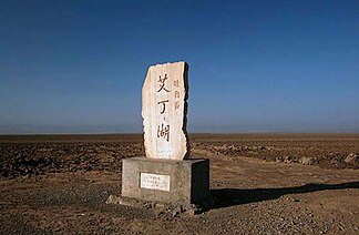
Stele at the salt marsh of the Depression , at the former Aydingkol lake . |
||
| location |
Xinjiang People's Republic of China |
|
| in the | Tian Shan | |
|
|
||
| Coordinates | 43 ° N , 89 ° E | |
| surface | 40,000 km² | |
| particularities | With 154 m below sea level deepest valley in China. | |
The Turpan Depression (or Turfan Depression , Chinese 吐魯番 盆地 , Pinyin Turpan Pendi ; Uighur تۇرپان ئويمانليغى, Turpan Oymanliƣi ) is a depression in eastern Xinjiang , an autonomous region in northwestern China ( Asia ).
geography
The basin-like Turpan Depression lies entirely in the Xinjiang Uyghur Autonomous Region of the People's Republic of China between 87 ° E to 97 ° E and 42 ° N to 43.5 ° N. Branches of the Tien Shan enclose them on all sides. Mainly these are the mountain ranges of Nan Shan in the west, Bogda Shan and Barkol Tagh in the north, and Kuruk Tagh (Chöl Tagh) in the south. The most important inflow of the basin without drainage is the Ala , which flows into the depression from the west, another river is the Baiyang. To the southwest of the depression is the Bosten Lake .
At the deepest point, which is about 150 km southeast of the provincial capital Ürümqi in the center of the 50,000 km² large Turpan Depression on Lake Aydingkol , the terrain on the shores of the lake drops to 155 m below sea level. This makes it one of the deepest depressions on earth after the area around the Dead Sea and the Sea of Galilee and almost on a par with Lake Assal . It could already be visited with dry feet in the pre-industrial age. Today, holes caused by human activities such as the Rhenish lignite opencast mines are deeper ( Hambach opencast mine approx. 290 m below sea level).
To the east the landscape opens up to the Gobi desert . Behind the northern mountains the great basin of the Djungary extends , beyond the southern mountains the Tarim basin . To the west is the Tian Shan Mountains.
geology
The Turpan Depression is a fault that arose not only as a result of the collision of the Indian subcontinent with Asia, since the Himalayas, among other things, were unfolded, but also because of movements within the Eurasian plate in the late Permian period. The depression was then further deformed during the Cenozoic .
The last deformation created a mountain range running from east to west, the Flaming Mountains , which was unfolded in the center of the basin by enormous pressure. The mountains, which are 98 km long and 9 km wide, reach a maximum height of 831.7 m.
climate
The climate in the Turpan Depression is extremely arid , windy and hot. The highest measured values are more than 40 m / s for the wind speed and 82.3 ° C for the ground temperature in the sand .
places
Inside or on the edge of the Turpan Depression are these places, among others:
- Turpan in the northern part of the valley
- Piqan (Shanshan), 80 km east of Turpan
- Toksun , 40 km west of Turpan
You can also find here:
- the ruined cities of Jiaohe and Kocho
- the Thousand Buddha Caves of Bäzäklik not far from the Flaming Mountains
- the Astana tombs
Individual evidence
- ↑ a b c d e f Allen, MB, Windley, BF, Chi, Z., & Jinghui, G. (1993). EVOLUTION OF THE TURFAN BASIN. TECTONICS, 12 (4), 889-896. ( PDF )
- ↑ Cavalazzi, B., et al. "The Dallol Geothermal Area, Northern Afar, Ethiopia — An Exceptional Planetary Field Analog on Earth." Astrobiology 19.4 (2019): 553-578. doi : 10.1089 / ast.2018.1926 . PMC 6459281 (free full text).
- ↑ Walker, AS (1981, March). Drainage in Gobi Terrain: a Mars Analog. In Lunar and Planetary Science Conference (Vol. 12, pp. 1127-1129). ( HTML )

