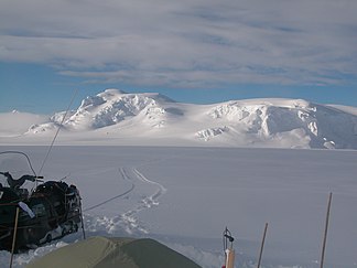
Bowles Ridge
| Bowles Ridge | ||
|---|---|---|
|
View across the Perunika Glacier to Bowles Ridge |
||
| Highest peak | Mount Bowles ( 834 m ) | |
| location | Livingston Island , South Shetland Islands | |
|
|
||
| Coordinates | 62 ° 37 ′ S , 60 ° 10 ′ W | |
Bowles Ridge ( Bulgarian Хребет Бовлес Chrebet Bowles ) is a 6.5 km long and 1.5 km wide mountain ridge on Livingston Island in the archipelago of the South Shetland Islands . It is enclosed by the Kaliakra Glacier in the north, the Perunika Glacier in the west and southwest and the Huron Glacier in the southeast and east.
British scientists mapped it in 1968. Bulgarian scientists in 2002 derived its name from that of its highest peak. This is named after the British Admiral William Bowles (1780-1869), from 1816 to 1820 commander-in-chief of the Pacific Station .
Web links
- Bowles Ridge in the Composite Gazetteer of Antarctica (English)

