Brady Glacier
| Brady Glacier | ||
|---|---|---|
|
Brady Glacier tongue |
||
| location | Alaska ( USA ) | |
| Mountains | Fairweather Range ( Elias chain ) | |
| Type | Valley glacier | |
| length | 39 km | |
| Exposure | south | |
| Altitude range | 800 m - 0 m | |
| width | ⌀ 4 km | |
| Coordinates | 58 ° 35 ′ N , 136 ° 47 ′ W | |
|
|
||
| drainage | Taylor Bay ( Cross Sound ) | |
| particularities | Tidal glaciers ; Glacier retreat | |
|
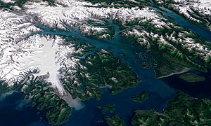
Satellite image of Glacier Bay National Park with Brady Glacier on the left. |
||
The Brady Glacier is a 39 km long glacier in the US state of Alaska . It is located in Glacier Bay National Park in the Alaska Panhandle about 74 km northwest of Hoonah .
geography
The Brady Glacier flows south from the Brady Icefield , located in the southern Fairweather Range , and ends at the head of Taylor Bay , a small bay north of the Cross Sound .
Glacier development
The glacier was first sighted in 1794 by British explorer George Vancouver . In the meantime, the glacier has retreated 8 km.
Naming
The glacier was named after John Green Brady , 1897-1909 Governor of the District of Alaska .
Web links
Commons : Brady Glacier - Collection of Images, Videos, and Audio Files
Individual evidence
- ↑ a b Brady Glacier in the Geographic Names Information System of the United States Geological Survey
- ↑ Mauri Pelto: Brady Glacier, Alaska begins a substantial retreat. February 18, 2010, accessed January 8, 2014 .


