Braminsee
| Braminsee | ||
|---|---|---|

|
||
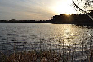
| Braminsee in the evening sun from the east bank | ||
| Geographical location | Ostprignitz-Ruppin district | |
| Tributaries | different streams | |
| Drain | Mühlbach in the Kagarsee | |
| Location close to the shore | Kagar , Flecken Zechlin , Rheinsberg | |
| Data | ||
| Coordinates | 53 ° 8 '15 " N , 12 ° 48' 9" E | |
|
|
||
| Altitude above sea level | 56.2 m above sea level NHN | |
| surface | 68 ha | |
| length | 1500 m | |
| width | 660 m | |
| volume | 1.05 million m³ | |
| Maximum depth | 2 m | |
| Catchment area | 2645 ha | |
|
particularities |
in private ownership |
|
The Braminsee is located within the Stechlin-Ruppiner Land nature park between the towns of Kagar and Dorf Zechlin near Rheinsberg in the Ostprignitz-Ruppin district in northern Brandenburg , and is part of the Rheinsberg Lake District .
The lake has an area of about 68 hectares. The maximum water depth is about 2 meters. The lakeshore is covered with reeds and water lilies . Entering the island in the lake is prohibited. The lake has no navigable connection to other lakes and use by watercraft is also prohibited. The Braminsee has no swimming area and no public access.
In spring 2007, a private owner acquired Braminsee from BVVG .
The management is carried out by a professional fisherman. No fishing permits are issued.
Individual evidence
- ↑ a b c d e f State Office for the Environment Brandenburg: Lake profile ( memento of the original from May 13, 2014 in the Internet Archive ) Info: The archive link was automatically inserted and not yet checked. Please check the original and archive link according to the instructions and then remove this notice.

