Brdská vrchovina
Coordinates: 49 ° 45 ′ 0 ″ N , 13 ° 45 ′ 0 ″ E
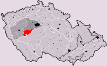
The Brdská vrchovina (German Brdy-Bergland , pronunciation: birrdi ) is a mountain range in the Czech Republic , in western Central Bohemia . It stretches over 827 km² from Prague west to Pilsen . The highest mountain is the Tok (865 m above sea level), which is also the highest mountain in Central Bohemia. A large part of the mountains - especially Zentralbrdy - was part of the Brdy military training area , which was closed on December 31, 2015. In its place the establishment of a landscape protection park (Chráněná krajinná oblast Brdy) is planned.
The Brdská vrchovina is part of the geomorphological unit Brdská oblast (approximately Brdy area ).
According to the current classification, the area is subdivided into
- Brdy in the narrower sense (German: Brdywald , Mittelböhmisches Waldgebirge , Hornwald or Kammwald ) in the west
- Hřebeny in the northeast (near Zbraslav ),
- Příbramská pahorkatina (German: Pribramer Hochland ) as a promontory south of both mountain ranges.
Web links
Individual evidence
- ↑ Military geographic description of the Sudetenlaender (1938) ( Memento of the original from May 23, 2015 in the Internet Archive ) Info: The archive link was automatically inserted and not yet checked. Please check the original and archive link according to the instructions and then remove this notice. , P. 19.

