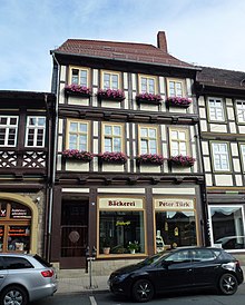
Breite Strasse 76 (Wernigerode)
The house at Breite Straße 76 is a listed building in the town of Wernigerode in the Harz district in Saxony-Anhalt . It is a residential and commercial building.
Architecture and history
The building is located in the historic Neustadt of Wernigerode on the south side of Breite Strasse , one of the city's main shopping streets. It is three stories. The roof was not removed.
The main building on the street side was built with functional, simple half-timbering with decorated crossbeams. The first and second floors are each designed symmetrically.
During the bombing raid on Wernigerode in February 1944, the neighboring building to the east was badly hit and partly destroyed, while the house at Breite Straße 76 was largely spared.
Since the 19th century there has been a shop on the lower floor of the Breite Straße 76 building with an entrance area that can be locked through an iron gate and two large shop windows facing the street, which is currently used by a private bakery from Hasserode . On the other hand, there are holiday apartments on the two upper floors.
The building used to have the location list number 389. Originally it was a residential building with a courtyard, wash house and stable. The house owner was the pastry chef Karl Renke in 1895/1896 and his son Otto Renke junior in 1905.
In the monument register of the city of Wernigerode, the house at Breite Straße 76 is listed as a monument under registration number 094 03269.
literature
- Hermann Dieter Oemler : Half-timbered in Wernigerode. Oemler Verlag, Wernigerode 1999, ISBN 3-9805751-1-X .
Web links
Individual evidence
- ^ Apartments, Wernigerode, Breite Strasse 76
- ↑ Short question and answer Olaf Meister (Bündnis 90 / Die Grünen), Prof. Dr. Claudia Dalbert (Bündnis 90 / Die Grünen), Ministry of Culture March 19, 2015: Printed matter 6/3905 (KA 6/8670) List of monuments Saxony-Anhalt , Magdeburg.pdf, page 2381
Coordinates: 51 ° 50 ′ 7.8 " N , 10 ° 47 ′ 25.8" E

