Bridger Bay
| Bridger Bay | ||
|---|---|---|
|
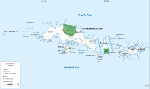
Map of Coronation Island (center) with Bridger Bay |
||
| Waters | Scotia Lake | |
| Land mass | Coronation Island , South Orkney Islands | |
| Geographical location | 60 ° 33 ′ 0 ″ S , 45 ° 51 ′ 0 ″ W | |
|
|
||
| width | 4 km | |
The Bridger Bay is a 4km wide and semicircular bay on the north coast of Coronation Iceland in Archipelago of the South Orkney Islands . It is west of Tickell Head .
The British whaling captain George Powell (1794-1824) and his American counterpart Nathaniel Palmer discovered the bay together in December 1821. The Falkland Island Dependencies Survey (FIDS) surveyed the bay between 1956 and 1958. The UK Antarctic Place-Names Committee named them on July 7, 1959 after John Frederick Douglas Bridger (1930-1994), who was involved in the survey work of the FIDS on Coronation Island and Signy Island .
Web links
- Bridger Bay in the Geographic Names Information System of the United States Geological Survey (English)
- Bridger Bay on geographic.org (English)

