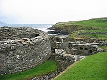
Broch from Midhowe
The Midhowe Broch is located opposite the island of Eynhallow directly on the estuary of the same name, on the west side of the Orkney island of Rousay in Scotland . Nearby are the ruins of two other Brochs (hence the name Midhowe = middle hill) and the Passage tomb ( Stalled Cairn ) of Midhowe. The Broch and the other buildings were excavated between 1930 and 1933. Before the excavation, it was just a grassy hill about six meters high and about nine meters above the low water mark on a small headland. The reason for the exposed location is that the building materials are almost ready for installation due to coastal erosion .
description
During the last centuries before the new era, the promontory, which was almost at sea level, on which the Broch was built, was separated from the hinterland by a double ditch. Perhaps there was an earth wall between the trenches.
Later, immediately behind the outer ditch, first an earth wall, then a massive wall was built and the inner ditch was partially filled. Such walls are rare. The Midhowes Wall has counterparts in the Shetland Islands ( Ness of Burgi ) and at Nybster in Caithness . Within the walled area, the double-walled broch (galleried broch) was built with a wall about five meters wide around an inner area about ten meters. The construction method common on the Scottish mainland is probably only represented in the early phase on Orkney. The walls of later Brochs on Orkney are massive, but there is no dated evidence to support this assumption. The Midhowe Broch has the usual built-in components such as a gallery, stairs and guard cell .
A small complex of stone buildings was erected on the north side of the Broch. Gradually, this interior development was extended towards the wall. There is evidence that the Midhowe houses were built later than the Broch. It is unknown how much of the promontory has been lost to the sea over the millennia.
The remains of fixtures and stoves were found inside the brochure . They mainly come from the late phase of use. The broch collapsed or was destroyed during the Iron Age . The inside was filled with stones and outside were the remains of buttresses.
Stone and bone tools indicate agriculture and handicrafts such as grain processing , spinning and weaving . The brochure provided evidence of trade and metallurgy . Bronze was made into fibulae , fragments of crucibles and casting molds were found. One building contained a forge, so that iron was probably also used , but this is not proven by artifacts. Shards of Roman pottery and a bronze (patera) ladle indicate at least indirect contact with the Romans.
The Midhowe Cairn is in the immediate vicinity .
literature
- Noel Fojut: The brochs of Gurness and Midhowe. Edited by Chris Tabraham. Historic Scotland, Edinburgh 1993, ISBN 0-7480-0466-1 , (guide booklet )
- John W. Hedges: Bu, Gurness and the brochs of Orkney (= British Archaeological Reports. British series. 163-165). 3 volumes. Oxford, BAR 1987.
Web links
- Entry to Midhowe Broch in Canmore, Historic Environment Scotland database
Coordinates: 59 ° 9 '12.3 " N , 3 ° 5' 49.4" W.

