Buchau (island)
| Buchau (Cow Island) |
||
|---|---|---|
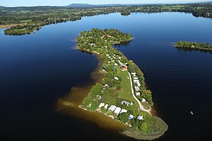
| Oblique aerial view of the island of Buchau from the southeast | ||
| Waters | Staffelsee | |
| Geographical location | 47 ° 41 ′ 35 " N , 11 ° 10 ′ 20" E | |
|
|
||
| length | 550 m | |
| width | 170 m | |
| surface | 4,542 ha | |
| Highest elevation | "Weissbierhügel" 659 m |
|
| Residents | uninhabited | |
| Map of the Staffelsee | ||
Buchau , formerly also Buch , is the second largest of the seven islands in the Staffelsee after Wörth . The name of the island is used with the feminine gender ( Die Buchau ). Another variant of the name is Kuhinsel . In the past, farmers let their Murnau-Werdenfelser cattle graze on the island .
The island is located in the northern part of the Untersee lake, around 100 meters from the eastern shore of the lake near the Kühle headland near the town of Seehausen . Like the other islands in the Staffelsee and the Staffelsee itself, it belongs to the municipality and district of Seehausen am Staffelsee in the Garmisch-Partenkirchen district in Bavaria .
The 45,420 m² island is privately owned by the municipality of Seehausen am Staffelsee and is leased as a whole as a campsite . The campsite on the car-free island is only permitted for tents , it extends over a large part of the island area from the north bank to the south bank. It has a total of 220 tent sites, 140 of which are permanent. The camping season lasts from April 15 to October 15, after which the permanent tents have to be dismantled down to the poles. The island is only inhabited seasonally. Motor vehicles and caravans are not allowed. The only buildings are the Burgstüberl restaurant and three buildings with sanitary facilities for campers. The island is regularly approached by the Staffelseeschiffahrt from April 1 to November 1 from Seehausen (north bank of the Burg peninsula) with the ferry d'fischerin , which runs every 80 minutes. The landing stage is in the southeast of the island. The island is part of a protected landscape area .
On the historical land map of the 19th century, the highest point of the island is marked with a geometric signal , this is at 659 meters and thus rises above the lake level (648.59 meters) by around 10.5 meters. This hill is known today as the "wheat beer hill". Another elevation, around five meters lower and to the west of the restaurant, is called the Mouse Hill.
The island was privately owned until 1960 when the municipality of Seehausen bought it for DM 230,000. The campsite has been in operation since 1961. The new inn has been standing since 2003.
Individual evidence
- ↑ a b Historic land map (early 19th century)
- ↑ Municipality of Uffing: Historical Staffelseekarte. Bürgerblatt 34/2014, p. 21
- ↑ a b Monika Maier-Albang: Birds of Paradise. The permanent campers from the Staffelsee leave the rest of the world behind on the mainland. Süddeutsche Zeitung, July 9, 2015, p. 33.
- ↑ Seehausen am Staffelsee: Camping
- ↑ Camping Island Buchau


