Bintuni Bay
| Bintuni Bay Teluk Bintuni |
||
|---|---|---|
|
Vogelkopf and Bomberai Peninsula |
||
| Waters | Berau Bay , Seramsee | |
| Land mass | Bomberai Peninsula , Vogelkop | |
| Geographical location | 2 ° 19 '58 " S , 133 ° 17' 25" E | |
|
|
||
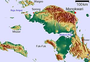
The Bay of Bintuni ( Indonesian Teluk Bintuni , also Bentuni Bay ) is located between the Vogelkop and Bomberai Peninsula in the west of the island of New Guinea .
geography
The area is part of the Indonesian province of Papua Barat . The Teluk Bintuni administrative region completely encloses the bay. To the west, the Bay of Bintuni widens into the Berau Bay , which in turn opens into the Seram Sea to the west . In the south is the Bomberai Peninsula, with the islands of Amutu Besar and Asap off the coast. In the north the bay is bounded by the Vogelkop peninsula.
Individual evidence
- ↑ The Great World Atlas, Millennium House, 2009, ISBN 978-1-921209-31-4 .

