
Papua Barat
| Papua Barat | |
|---|---|
 |
|
| Basic data | |
| Area : | 115,364 km² |
| Residents : | 871,500 |
| Population density : | 8 inhabitants / km² |
| Capital : | Manokwari |
| governor | Dominggus Mandacan |
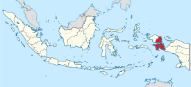
| Location in Indonesia | |
  |
|
| Website : | www.papuabaratprov.go.id |
Papua Barat (German West Papua ; until 2007 Irian Jaya Barat , German West Irian Jaya ) is a province in Western New Guinea , the Indonesian part of New Guinea . It is currently the scene of the Papuan conflict .
Geographical location
Papua Barat was separated from Papua Province in 2003 , against the will of the indigenous Papuans , who saw it as an interference with their autonomy.
Papua Barat comprises the westernmost part of Western New Guinea with the Vogelkop Peninsula , the Bomberai Peninsula and offshore islands, including the Raja Ampat archipelago with Waigeo and Misool .
The population is made up of indigenous Papuans and Malays who immigrated as part of the Indonesian migration policy (“ Transmigrasi ”) and who now form the majority. The capital is Manokwari with 130,000 inhabitants, the second important city is Sorong with around 125,000 inhabitants.
| Government district (Kabupaten) | Area (km 2 ) | Population (2010 census) |
Population (2014 estimate) |
Capital | Number of districts |
|---|---|---|---|---|---|
| Sorong (city) | 656.64 | 190,625 | 219,958 | Sorong | 6th |
| Fakfak | 11,036.48 | 66,828 | 77.112 | Fakfak | 9 |
| Kaimana | 16,241.84 | 46,249 | 53,366 | Kaimana | 7th |
| Manokwari | 14,250.94 | 187.726 | 216.614 | Manokwari | 29 |
| South Manokwari (Manokwari Selatan) | 18,564 | - | Ransiki | 6th | |
| Maybrat Regency | 5,461.69 | 33,081 | 38,067 | Kumurkek | 11 |
|
Pegunungan Arfak ( Arfak Mountains ) |
2,773.74 | 23,877 | - | Anggi | 10 |
| Raja Ampat | 8,034.44 | 42,507 | 49,048 | Wasai (Waisai) | 17th |
| Sorong | 7,415.29 | 70,619 | 81,486 | Aimas | 18th |
| South Sorong ( Sorong Selatan ) | 3,946.94 | 37,900 | 43,898 | Teminabuan | 14th |
| Tambrauw | 5,179.65 | 6,144 | 7,028 | Fef | 7th |
| Teluk Bintuni | 20,840.83 | 52,422 | 60,489 | Bintuni | 24 |
| Teluk Wondama | 3,959.53 | 26,321 | 30,371 | Rasiei | 13 |
Nature reserves

As the least developed part of Western New Guinea, Papua Barat is still more than half covered by jungle. This biotope is endangered by the advance of modern technology in search of precious woods (especially merbau ) and mineral resources. The destruction of the unique fauna is to be countered by setting up nature reserves (at least on paper). Penetrating these areas requires the equipment and experience of expedition travelers.
Designated nature reserves Papua Barats:
- Pulau Raja Ampat , about 2200 km² in size, includes the islands of Waigeo , Batanta and Salawati , home to marsupials and some endemic bird species, including birds of paradise .
- Gunung Meja , only about 5 km² in size, is important because of its bird life. The larger nature reserves of this region on the Cendrawasih Peninsula around the Tamrau and Arfak Mountains are more difficult to access and walk. Leatherback turtles can be observed here.
- Pegunungan Wandiwoi is located south of Manokwari in the Wandiwoi Mountains on the Cendrawasih Peninsula. Various birds can also be observed here, such as bower or gardening birds. A marine reserve has been set up around the peninsula to protect coral gardens, seabird breeding colonies and pastures for sea turtles.
Web links
Coordinates: 1 ° 0 ′ S , 134 ° 0 ′ E
Aceh | Bali | Bangka Belitung | Banten | Bengkulu | Gorontalo | Jakarta | Jambi | Jawa Barat | Jawa Tengah | East Java | Kalimantan Barat | Kalimantan Selatan | Kalimantan Tengah | Kalimantan Timur | Kalimantan Utara | Lampung | Maluku | Maluku Utara | Nusa Tenggara Barat | Nusa Tenggara Timur | Papua | Papua Barat | Riau | Kepulauan Riau | Sulawesi Barat | Sulawesi Selatan | Sulawesi Tengah | Sulawesi Tenggara | Sulawesi Utara | Sumatra Barat | Sumatra Selatan | Sumatra Utara | Yogyakarta