
Riau
| Riau | |
|---|---|
 |
|
| Basic data | |
| Area : | 87,024 km² |
| Residents : | 6,074,100 |
| Population density : | 70 inhabitants / km² |
| Capital : | Pekanbaru |
| governor | H. Syamsuar (since February 20, 2019) |
| Location in Indonesia | |
  |
|
| Website : | www.riau.go.id |
Riau is an Indonesian province in the east of the island of Sumatra .
geography
Riau is located in the flat, swamps-traversed eastern part of Sumatra on the Strait of Malacca .
Only separated by narrow inlets are flat islands (indones .: 'Pulau') on the coast:
- Rupat (with the largest town Batupanjang)
- Bengkalis (with the capital of the same name)
- Padang
- Rank
- Rantau
- Penyeler (with the main town Mendung), right in front of the mouth of the Kampar River
The island of Kundur , east of Penyeler, already belongs to the Riau Islands ( Kepulauan Riau ), which have been a province of their own since 2004.
Other coastal islands lie in front of the mouth of the Indragiri , near the city of Tembilahan. A little to the south, in front of the mouth of the Batang Hari , are two small islands.

Rivers are Siak , Indragiri, Kampar and Rokam.
Riau owns a variety of natural resources such as petroleum , natural gas , rubber , palm oil , fish and wood .
The capital of the province is Pekanbaru .
Administrative division
| Code Wilayah area code |
coat of arms | Kabupaten / Kota administrative district / city |
Ibu Kota seat of government! |
Kecamatan Sub- District |
Keluruhan / Desa municipality |
Area [km²] | Population [2019] |
Inh. / Km² [2019] |
|---|---|---|---|---|---|---|---|---|
| 14.01 |  |
Kabupaten Kampar | Bangkinang | 21st | 8/242 | 10,983.47 | 748.956 | 68.2 |
| 02/14 |  |
Kabupaten Iindragiri Hulu | Rengat | 14th | 16/178 | 7,723.8 | 427.771 | 55.4 |
| 14.03 |  |
Kabupaten Bengkalis | Bengkalis | 11 | 19/136 | 6,975.41 | 544.144 | 78.0 |
| 04/14 |  |
Kabupaten Indragiri Hilir | Tembilahan | 20th | 39/197 | 12,614.78 | 622.281 | 49.3 |
| 14.05 | Kabupaten Pelalawan | Pangkalan Kerinci | 12 | 14/104 | 12,758.45 | 369.048 | 28.9 | |
| 14.06 |  |
Kabupaten Rokan Hulu | Pasir Pangaraian | 16 | 6/139 | 7,588.13 | 556.199 | 73.3 |
| 14.07 |  |
Kabupaten Rokan Hilir | Bagansiapiapi | 18th | 25/159 | 8,881.59 | 638.679 | 71.9 |
| 08/14 |  |
Kabupaten Siak | Siak Sri Indrapura | 14th | 9/122 | 8275.18 | 422,869 | 51.1 |
| 14.09 |  |
Kabupaten Kuantan Singingi | Teluk Kuantan | 15th | 11/218 | 5,259.36 | 330.966 | 62.9 |
| 14.10 |  |
Kabupaten Kepulauan Meranti | Selat Panjang | 9 | 5/96 | 3,707.84 | 208,580 | 56.3 |
| 14.71 |  |
Kota Pekanbaru | Pekanbaru | 12 | 83 / - | 632.27 | 915.866 | 1,448.5 |
| 14.72 |  |
Kota Dumai | Dumai | 7th | 33 / - | 1,623.38 | 288,741 | 177.9 |
| 14th | Provinsi Riau | Pekanbaru | 169 | 268/1591 | 87,023.66 | 6,074,100 | 69.8 | |
Source: Peraturan Menteri Dalam Negeri RI Nomor 72 Tahun 2019 (ordinance of the Minister of the Interior of October 2019):
The population information is based on updates by the regional civil registration offices and comes from the first half of 2019.
history
The strategically favorable location on the Strait of Malacca and thus the shortest sea route from the Chinese Empire to India determined the importance of the region early on. Since the 15th century, when Sumatra was Islamized , Riau was under the influence of the Empire of Malacca , later a separate sultanate was established here .
The European colonial powers Portugal , Great Britain and the Netherlands fought for influence before all of Sumatra was assigned to the Netherlands in the British-Dutch Treaty of 1824 . The region proved stubborn; it was not until 1911 that the sultanate was abolished and a Dutch colonial administration established. In 1949 Riau became a province of the now independent Indonesia.
ecology
Intensive timber industry ( paper , pulp and wood production ) has been practiced in Riau since 1999 . In addition, palm oil plantations were established. Since then, around 3 km² of tropical rainforest has been disappearing every day , which corresponds to 600 soccer fields ; therefore protected areas are becoming more and more important. The risk of forest fires has risen sharply due to droughts. In 2010 arson broke out on the peat bog, which impaired air quality as far as Malaysia and Singapore. In 2015 there were again forest fires that lasted for weeks.
National parks

In the south of Riau there are several national parks and reserves that are also supported by the WWF .
- Tesso Nilo National Park (planned: 1500 km², comparison: Saarland 1930 km²)
- Bukit Tigapuluh National Park
- Kerumutan Reserves
- Bukit Rimbang and Bukit Baling Reserves
The Sumatran elephant , which is now extremely threatened, lives in these national parks and reserves , of which around 1,600 specimens were counted in Riau in 1985, but today only just under 400.
population
The population is made up of more than ten different ethnic groups. 87.8% of the population belongs to Sunni Islam, minorities are Buddhists (6%), Catholics (5%), Protestants (1%) and Hindus (0.2%). Traditionally, Orthodox Islam is predominant.
Spoken in Riau expression of the Malay language was the model for the far part uniform, in Malaysia and in Indonesia on local dialects and languages used Malay .
Attractions

The Siak Sri Inderapura Palace
(built in 1889)
The great mosque of Pekanbaru
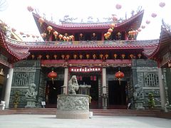
Temple in Selatpanjang> br /> (Kab.Kep.Meranti)

Bakar Tongkang Festival 2019 in Bagiansiapai
(Kab.Rokan Hilir)
Masjid ar-Rahman Mosque in Pekanbaru
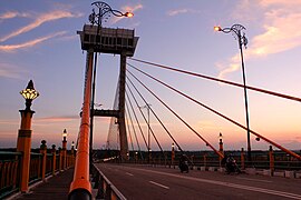
The Tengku Agung Sultanah Latifah Bridge in Siak
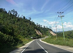
Highway

Temple in Bagiansiapai


.JPG)


Web links
Individual evidence
- ↑ http://indonesiabangun.tripod.com/welcome_to_sumatra_island.htm
- ↑ Peraturan Menteri Dalam Negeri RI Nomor 72 Tahun 2019: page 6, 661
Aceh | Bali | Bangka Belitung | Banten | Bengkulu | Gorontalo | Jakarta | Jambi | Jawa Barat | Jawa Tengah | East Java | Kalimantan Barat | Kalimantan Selatan | Kalimantan Tengah | Kalimantan Timur | Kalimantan Utara | Lampung | Maluku | Maluku Utara | Nusa Tenggara Barat | Nusa Tenggara Timur | Papua | Papua Barat | Riau | Kepulauan Riau | Sulawesi Barat | Sulawesi Selatan | Sulawesi Tengah | Sulawesi Tenggara | Sulawesi Utara | Sumatra Barat | Sumatra Selatan | Sumatra Utara | Yogyakarta
Coordinates: 0 ° 30 ' N , 101 ° 0' E