
Kalimantan Utara
| Kalimantan Utara | |
|---|---|
 |
|
| Basic data | |
| Area : | 72,567 km² |
| Residents : | 738.163 |
| Population density : | 10 inhabitants / km² |
| Capital : | Tanjung Selor |
| governor | Irianto Lambrie |
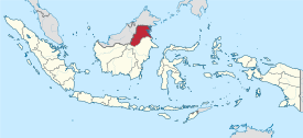
| Location in Indonesia | |
  |
|
| Website : | http://kaltaraprov.go.id/ |
_topographic_map_-_id.svg)
Kalimantan Utara ( Northern Kalimantan ) is a province of Indonesia in the northeast of the island of Borneo .
geography
The province borders in the west on Sabah (Malaysia) , in the north on Sarawak | Sarawak (Malaysia) and in the south on the province Kalimantan Timur . In the east the Celebes Sea ( according to Sulawesi ) forms the natural border. The province has an area of 75,467.70 km² (13.84% of the area of the Indonesian part of the island of Borneo) and is the second smallest before the province of Kalimantan Selatan .
The province includes 849,615 islands, more than half (499,363) of which belong to the Bulungan administrative district.
Administrative division
| Code Wilayah area code |
coat of arms | Kabupaten / Kota administrative district / city |
Ibu Kota seat of government! |
Kecamatan Sub- District |
Keluruhan / Desa municipality |
Area [km²] | Population [2019] |
Inh. / Km² [2019] |
|---|---|---|---|---|---|---|---|---|
| 65.01 |  |
Kabupaten Bulungan | Tanjung Selor | 10 | 7/74 | 13,925.72 | 140,527 | 10.1 |
| 65.02 |  |
Kabupaten Malinau | Malinau | 15th | - / 109 | 42,620.70 | 80,822 | 1.9 |
| 65.03 |  |
Kabupaten Nunukan | Nununkan | 19th | 8/232 | 13,841.90 | 182.028 | 13.2 |
| 65.04 |  |
Kabupaten Tana Tleid | Tideng Pale | 5 | - / 32 | 4,828.58 | 24,145 | 5.0 |
| 65.71 |  |
Kota Tarakan | Tarakan | 4th | 20 / - | 250.80 | 231.013 | 921.1 |
| 65 | Provinsi Kalimantan Utara | Tanjung Selor | 53 | 35/447 | 75,467.70 | 658,535 | 8.7 | |
Source of the administrative and area data: Peraturan Menteri Dalam Negeri RI Nomor 72 Tahun 2019 (Ordinance of the Minister of the Interior of October 2019):
The population data are based on updates by the regional civil registration offices and are from the end of 2019
population
With 658,000 inhabitants, the province of Kalimantan Utara ranks last of all 34 provinces. The proportion of Kalimantan is 4.02%.
73% of the population are Islamists, 20.28% are Protestants and 6.02% are Catholics. The other beliefs are each represented with less than one percent.
history
The province was founded on November 16, 2012 as the 34th province of Indonesia. Until then, the four administrative districts ( Kabupaten ) and the city ( Kota ) of Tarak belonged to the province of Kalimantan Timur.
literature
- Herwig Zahorka: Kerayan - an inaccessible highland in the interior of Borneo with megaliths, wet rice cultures and missionary work from the air. In: Tribus - Yearbook of the Linden Museum Stuttgart, Vol. 55, 2006, pp. 221–245
Web links
Individual evidence
- ↑ Provinsi Maluku Utara Dalam Angka 2020, p. 13 (66)
- ↑ Peraturan Menteri Dalam Negeri RI Nomor 72 Tahun 2019: page 6, 2783
- ↑ Visualisasi Data Kependudukan , clickable map
- ↑ Directorate Jenderal Kependudukan dan Pencatatan Sipil - Kementerian Dalam Negeri - Peta Persebaran Agama - Provinsi 2019 , clickable map
- ↑ The Jakarta Globe: House Agrees on Creation of Indonesia's 34th Province: 'North Kalimantan' , October 22, 2012 ( Memento of January 4, 2014 in the Internet Archive )
Aceh | Bali | Bangka Belitung | Banten | Bengkulu | Gorontalo | Jakarta | Jambi | Jawa Barat | Jawa Tengah | East Java | Kalimantan Barat | Kalimantan Selatan | Kalimantan Tengah | Kalimantan Timur | Kalimantan Utara | Lampung | Maluku | Maluku Utara | Nusa Tenggara Barat | Nusa Tenggara Timur | Papua | Papua Barat | Riau | Kepulauan Riau | Sulawesi Barat | Sulawesi Selatan | Sulawesi Tengah | Sulawesi Tenggara | Sulawesi Utara | Sumatra Barat | Sumatra Selatan | Sumatra Utara | Yogyakarta
Coordinates: 3 ° 0 ' N , 117 ° 0' E