Berau Bay
| Bay of Berau Teluk Berau |
||
|---|---|---|
|
Vogelkopf and Bomberai Peninsula. The Berau Bay extends west of the Bay of Bintuni. |
||
| Waters | Berau Bay, Seramsee | |
| Land mass | Bomberai Peninsula , Vogelkop | |
| Geographical location | 2 ° 27 '46 " S , 132 ° 31' 6" O | |
|
|
||
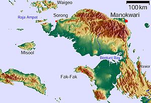
The Berau Bay ( Indonesian Teluk Berau ), formerly McCluer Gulf (MacCluer Gulf) is located between the Vogelkop and Bomberai Peninsula in the west of the island of New Guinea .
geography
The Berau Bay forms the widening of the eastern bay of Bintuni and separates the Vogelkop Peninsula in the north from the Bomberai Peninsula, with its western extension, the Fakfak Peninsula , in the south. To the west lies the open Seramsee . In front of the Fakfak peninsula are the islands of Ogar and Arguni .
The area is part of the Indonesian province of Papua Barat . The administrative district of Fakfak occupies the southern bank, while the coast of the bay on Vogelkop belongs to the administrative districts of Teluk Bintuni and South Sorong (Sorong Selatan).
history
On the coast, rock paintings testify to the settlement of the region in the Holocene .
Web links
Individual evidence
- ↑ The Great World Atlas, Millennium House, 2009, ISBN 978-1-921209-31-4 .
- ^ Sue O'Connor: Nine New Painted Rock Art Sites from East Timor in the Context of the Western Pacific Region , pp. 20 ff., Asia Perspectives, Vol. 42, No.1, 2003 , accessed April 6, 2020.

