Harchheim castle ruins
| Harchheim castle ruins | ||
|---|---|---|
|
Castle Hill |
||
| Alternative name (s): | Burgstall ruins | |
| Castle type : | Höhenburg, rocky location | |
| Conservation status: | Burgstall, small remains of the wall | |
| Place: | St. Aegidi | |
| Geographical location | 48 ° 27 '35 " N , 13 ° 46' 13" E | |
|
|
||
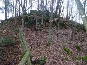
The castle ruins Harchheim , also known as Ruin Postal referred, is an Outbound rock castle on a rock above the Kleine-Kössl Bach Gorge in the middle of a conservation area in the district Tullern the municipality of St. Aegidi in the district of Schärding in Upper Austria .
history
Little news of the former castle has survived. Heinrich von Harchhaim is mentioned in 1260 and Her Peter von Harchheim in 1307. The Harchhaimers are mentioned as a knightly family in various documents in the 15th century. In 1536 the governor of Upper Austria ordered that delinquent residents of Niederkeßla be sentenced and locked up in the castle. However, since the castle stables were already very dilapidated at the beginning of the 16th century, the seat of the court was moved to St. Aegidi half a century later (1583). Most of the building material was used for the new construction of the St. Pankratius Church, which was built in 1550 by the Engelszell Abbot Pankrazius on the site of an earlier building. This church has also been closed by Emperor Joseph II since 1784 . The St. Pankratius Chapel , which still exists today, was built in its place .
The lower Kleine Kößlbach has always formed a natural border between the lordships, communities and parishes, which were partly Passau, partly Austria, but for centuries there were disputes about this area. Only with a 1765 between Empress Maria Theresia and the Prince-Bishop Leopold III. The state treaty concluded by Passau stipulated that St. Aegidi belongs to Austria.
Harchheim ruins today
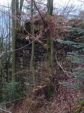
All that remains of the earlier castle is a roughly floor-high wall square on the edge of steeply sloping rocks. The remaining wall remains represent the valley side of a rectangular building that was built on lining walls at the steepest and deepest point of the rock. they are made of quarry stone masonry with cut corner blocks and have a wall thickness of up to about two meters. Due to its exposed location, this part of the building could not be removed for the construction of the church. There are no more wall remains on the actual castle hill.
The Burgstall is located on the right bank of the Kesselbach, which flows into the Danube across from Rannariedl .
You can reach the castle from St. Aegidi, if you drive about 1.8 km on the Roßgatterstraße via Schauern, then take the Mittelbach-Güterweg to the Mittelbach farm no. 3; From there the path goes into the forest and after about 800 meters you reach the castle. Another possibility to reach the castle is the starting point from the St. Pankratius chapel, whereby you have to pay close attention to the trail markings and after about 500 m you have to turn left towards the Kösslbachschlucht.
literature
- Norbert Grabherr : Castles and palaces in Upper Austria. A guide for castle hikers and friends of home. 1976 (3rd revised edition), Linz: Oberösterreichischer Landesverlag, ISBN 3-85214-157-5 .


