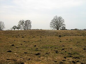
Burgwall Hühnerwinkel
| Burgwall Hühnerwinkel | ||
|---|---|---|
| Alternative name (s): | Wall Boock | |
| Creation time : | circa 7th century | |
| Castle type : | Niederungsburg | |
| Conservation status: | Secondary, earth relic | |
| Standing position : | Refuge | |
| Construction: | Earth walls with palisades | |
| Place: | Boock , Plöwen and Löcknitz | |
| Geographical location | 53 ° 28 '30.1 " N , 14 ° 15' 17" E | |
|
|
||
The Hühnerwinkel castle wall is the relic of a Slavic low castle in the districts of the communities Boock , Plöwen and Löcknitz in the district of Vorpommern-Greifswald in Mecklenburg-Western Pomerania .
location
The well visible and reconstructable ramparts are located on the edge of the Plöwen lake. The complex consists of at least three ramparts, the main castle and two smaller structures. The individual walls are connected by embankments. The castle complex is located in the then tribal area of the Ukranians and is said to have been used from the early to the Yaroslav times, i.e. from around the 7th to the 13th century. At the time it was used, the castle was surrounded by impassable moorland . The adjoining lake quarry was then an open body of water. The moor is now cultivated grassland and is drained through ditches. In the area adjoining the moorland to the south, a tongue-shaped wooded slab of basin sand located higher up , there is a double wall system to protect the access to the castle. A bailey is said to have existed in the protection of these walls. Not far from the ramparts there is a late Slavic barrow field . The Hühnerwinkel castle wall is part of the Plöwensches Seebruch nature reserve .
Hühnerwinkel castle wall (ground monument: Boock 25)
A multi-section fortification extends over a stretch of more than 1000 m in length and almost 400 m in width in Plöwen's Seebruch. The location was ideally suited for a prehistoric castle because of its natural protection in the midst of extensive lowlands.
Already several hundred meters before the actual castle wall, the access was cordoned off by a double wall and ditch system with palisades . In the area behind it, about 8 hectares in size, there was the outer bailey with residential and farm buildings. A dam led from there to the main castle , which was surrounded by a high wall made of earth and wood and the inner area measures around 80 × 100 m. The main castle is connected by dams to a smaller rampart about 50 m in diameter.
Slavic settlement sites, a cult site and burial grounds are known from the area around the castle complex, while there are no castles of comparable size. This indicates the special role this castle complex played in the Slavic settlement area between Randow and Uecker. In historical sources, the Ukrainian tribe is mentioned for this area in the 11th to 12th centuries AD.
The castle complex was examined as early as 1887. Search cuts were made in 1966, new measurements and superficial explorations were carried out in 1975 and 1979, the same also in 1985.
Main castle
The center of the extensive castle complex in Plöwen's Seebruch was the main castle, which was connected to the outer bailey and the small castle wall via dams. The ring-shaped wall of the main castle can still be seen today.
Originally the wall was certainly higher. During excavations of similar castles, it was found that the wall had an internal structure made of wood. The entire outer wall was clad with wood or stone, so that possible attackers faced a vertical, insurmountable wall.
Finds show that the castle was used for a period of 400 to 500 years and only in the 12th / 13th centuries. Century AD was abandoned.
Small ramparts
At the outermost protrusion in the middle of the swampy lowlands is the small castle wall, which closes the entire complex to the north.
A wooden bridge, which is still visible today in the form of a dam, served as access. The drawing on the information board gives an impression of the small castle wall and the bridge that connected it to the main castle. This access could easily be interrupted in the event of danger.
Because of its location, the Kleine Burgwall was suitable for protecting particularly sensitive goods. For example, it could have been an image of a god that was supposed to be protected from destruction at the time when Christianization was beginning. The cults of the Slavs came under increasing pressure, especially in the last phase of use of the castle complex.
literature
- Joachim Herrmann , Peter Donat : Corpus of archaeological sources on early history in the area of the German Democratic Republic. 2. Delivery, text tape. Berlin 1979. pp. 446-447.
- Description of the State Archaeological Museum and the State Office for Land Monument Preservation MV
- H. Schumann, In: Balt. Stud. 37 (Stettin 1887).
- O. Kunkel, In: NfDV 1927, p. 40.
- HJ Eggers, finds from the Wendish-Viking period in Pomerania (Kiel 1978).
- Notices of the district specialist. Neubrandenburg, 37, 1990, 46–49 (with det. Map)


