Busachi
| Busachi | ||
| Geographical location | ||
|
|
||
| Coordinates | 45 ° 7 ′ N , 51 ° 40 ′ E | |
| Waters 1 | Caspian Sea | |
| length | 100 km | |
| width | 100 km | |
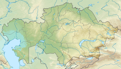
The Busachi peninsula ( Russian Бузачи , Kazakh Бұзашы / Buzaşı ) is an extensive depression in the northeast of the Caspian Sea . It is largely covered by salt marshes and lies 20 to 35 m below sea level, a few meters deeper than the Caspisee.
As a peninsula, it measures about 100 × 100 km, but the depression has almost three times that area. The climatically very dry area belongs to the Kazakh western province of Mangghystau and lies between the mountainous Mangyschlak peninsula in the south and the desert-like Ustyurt plateau in the southwest. In the north the area borders on the Kazakh province of Atyrau , where the Caspian Depression continues far to the north and east.
On the coast, the peninsula is bounded by two gulfs : in the north by the narrow and flat Mertwy Kultuk , which extends about 100 km between salt marshes and small islands, and in the south by Mangyschlakski Zaliv, which is initially 30 km wide and about 10 m is deep. The Mertwy Kultuk is also known as the Dead Sea ; its continuation inland was 170 km long around 1890 and is now partially silted up.
literature
- Central Asia map . In: Brockhaus Atlas , 1980
- Mertwy Kultuk . In: Brockhaus Konversations-Lexikon 1894–1896, Volume 11, p. 796.
- Mangischlat . In: Meyers Konversations-Lexikon . 4th edition. 1885-1892, p. 551
