
Bussento
| Bussento | ||
 |
||
| Data | ||
| location | Southwest Italy, Campania | |
| River system | Bussento | |
| River basin district | Appennino Meridionale | |
| source | La Raia del Pedale, Rofrano in Italy 40 ° 14 ′ 45 ″ N , 15 ° 27 ′ 24 ″ E |
|
| muzzle | at Policastro Bussentino in the Gulf of Policastro ( Tyrrhenian Sea ) Coordinates: 40 ° 3 '56 " N , 15 ° 30' 38" E 40 ° 3 '56 " N , 15 ° 30' 38" E
|
|
| length | 37 km | |
| Catchment area | 307 km² | |
The Bussento is a river in southwest Italy. It mostly runs in the Cilento and Vallo di Diano National Park . The communities on the river have come together to form the Comunità Montana del Bussento .
geography
The source of the Bussento rises at La Raia del Pedale, a 1,521 m high mountain near Rofrano in the province of Salerno ( Campania ). In the further course it flows first in an easterly direction past the north located Sanza , to then flow further in a south direction. It then disappears from the surface north of Caselle in Pittari , only to reappear five kilometers further south at Morigerati . After a short western course, the Bussento finally flows south into the Mediterranean, more precisely into the Tyrrhenian Sea at Policastro Bussentino .
Hydrology
The water of the Bussento comes mainly from the spring and smaller inlets.
Web links
- Official website of the mountain commune (Italian)
- Official website from Morigerati to Bussento (Italian)
Photo gallery

Mill on Bussento 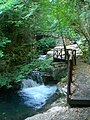
Watercourse

