Càrn Dearg (Monadh Liath)
| Càrn Dearg | ||
|---|---|---|
|
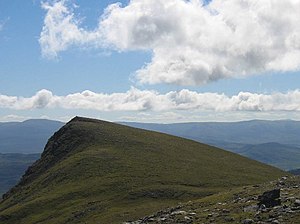
The summit of Càrn Dearg, seen from Càrn Bàn |
||
| height | 945 m ASL | |
| location | Highlands , Scotland | |
| Coordinates | 57 ° 5 ′ 31 ″ N , 4 ° 15 ′ 8 ″ W | |
|
|
||
The Càrn Dearg ( Spitzer Red Mountain in Gaelic ) is a 945 meter high mountain in Scotland . It is one of the Munros and represents the highest elevation of the Monadh Liath ( Gray Mountains in Gaelic), a mountain range in the northern Cairngorms in the Council Area Highland . The Monadh Liath are located on the western edge of the Cairngorms National Park , about five kilometers northwest of the towns of Kingussie and Newtonmore in the Spey valley
The Monadh Liath form a high plateau from which the various peaks are only slightly separated. The elongated summit ridge of the Càrn Dearg forms the southwestern end of the plateau. South of the highest point is the only slightly lower South-east Top (south -east summit) at 923 m . In this area, the Càrn Dearg runs out into a steep rocky ridge, to the east it rises steeply above the Glen Ballach . To the north is the flat plateau of the Monadh Liath, from which only the Càrn Bàn, which at 942 m almost reaches the height of the Càrn Dearg, protrudes slightly. Both peaks are only separated from each other by a shallow notch. The climb from Newtonmore requires around five to seven hours of walking.
Individual evidence
Web links
- The Càrn Dearg on walkhighlands.co.uk (English)
- The Càrn Dearg on munromagic.com (English)


