Cabalían
| Cabalían | ||
|---|---|---|
|
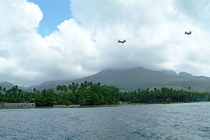
Cabalian bay with mountain in the background |
||
| height | 945 m | |
| location | Leyte Island , Philippines | |
| Coordinates | 10 ° 17 '8 " N , 125 ° 13' 4" E | |
|
|
||
| Type | Stratovolcano | |
| rock | Andesite | |
| Age of the rock | 510,000 | |
| Last eruption | 1820 ± 30 years | |
The Cabalian is 945 meters above sea towering stratovolcano on the island of Leyte in the Philippines .
The mountain is located on a peninsula at the southeast end of the island of Leyte and is covered with dense vegetation . A lake fills its crater at 945 meters . Its rock is classified as andesite . Its shape is described as very rugged and it has two smaller mountain peaks on its southern flank.
There are hot springs on its eastern and western flanks. A geothermal power plant will use these hot springs, it will have an output of up to 150 MW and will be connected to the grid in 2015.
source
- Cabalían in the Global Volcanism Program of the Smithsonian Institution (English)
Individual evidence
- ↑ Geothermie.de ( Memento of the original from January 31, 2012 in the Internet Archive ) Info: The archive link was inserted automatically and has not yet been checked. Please check the original and archive link according to the instructions and then remove this notice. (PDF, 8 MB)

