Cagua (Venezuela)
| Cagua | ||
|---|---|---|
|
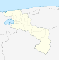
Coordinates: 10 ° 11 ′ N , 67 ° 27 ′ W Cagua on the map of Aragua
|
||
| Basic data | ||
| Country | Venezuela | |
| State | Aragua | |
| Residents | 114,445 (2017) | |
| Detailed data | ||
| height | 458 m | |
| Post Code | 2101-2104 | |
| Time zone | UTC -4: 30 | |
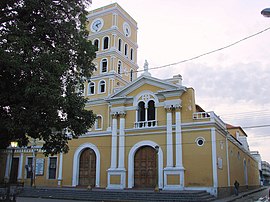
| Cagua Church | ||
Cagua is a city in Venezuela and the administrative seat of the Municipios Sucre . It is located at an altitude of 458 meters in the Aragua Valley, in the northwest of the state of Aragua.
Cagua is currently part of the Maracai metropolitan area. In 2017, about 114,445 people lived in Cagua.
Attractions
- San Jose Church
- El Molino de Piedra
- Guipuzcoana house
- Museum of Art and History
- Taiguaguai Lake
- Sucre Square
- Bolívar Square
- Los Meregotos Square
- Agustín Codazzi Park
- Culture house
Individual evidence
- ↑ Cagua ( Memento of the original from December 16, 2008 in the Internet Archive ) Info: The archive link was inserted automatically and has not yet been checked. Please check the original and archive link according to the instructions and then remove this notice. at ine.gov.ve, accessed on May 17, 2018.
- ↑ Aragua (Venezuela): Municipalities & Urban Places - Population Statistics, Graphics and Map. Retrieved April 15, 2018 .

