Cala Llombards (place)
| Santanyí municipality: Cala Llombards | ||
|---|---|---|

|
||
| coat of arms | Map of Spain | |
 Help on coat of arms |
|
|
| Basic data | ||
| Autonomous Community : | Balearic Islands | |
| Island: | Mallorca | |
| Comarca : | Migjorn | |
| Coordinates | 39 ° 19 ′ N , 3 ° 8 ′ E | |
| Residents : | 465 (2011) INE | |
| Postal code : | 07690 | |
| Area code: | 07057000900 | |
Cala Llombards is a place on the Spanish Balearic island of Mallorca . It is called Urbanització in Catalan , which means residential area or settlement.
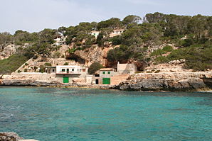
Cala Llombards is located in the southeast of Mallorca and belongs to the municipality of Santanyí . The place, which was built in the early 1960s and named after the bay of Cala Llombards , has over 450 inhabitants. Settlement construction on the property of the former Finca Son Amer began in 1969. Cala Llombards consists of single-family and holiday homes and a small hotel. Bay and town can be reached via the MA-6100 between Santanyí and Ses Salines . Branch in the place of the same name Es Llombards. Neighboring places are in the northeast Cala Santanyí and in the southwest the Cap de Ses Salines, which marks the southernmost point of the island.
The bay, which is shaded in the morning, is well suited for swimming thanks to the shallow beach and weak waves. There is a limited number of gastronomic offerings.
Individual evidence
- ↑ Es Llombards. (No longer available online.) Www.mallorca.com, May 28, 2013, archived from the original on March 4, 2016 ; Retrieved August 20, 2013 . Info: The archive link was inserted automatically and has not yet been checked. Please check the original and archive link according to the instructions and then remove this notice.
