Santanyí
| Santanyí municipality | ||
|---|---|---|
| coat of arms | Map of Spain | |

|
|
|
| Basic data | ||
| Autonomous Community : | Balearic Islands | |
| Island: | Mallorca | |
| Comarca : | Migjorn | |
| Coordinates | 39 ° 21 ' N , 3 ° 8' E | |
| Height : | 62 msnm | |
| Area : | 124.47 km² | |
| Residents : | 12,237 (Jan 1, 2019) | |
| Population density : | 98.31 inhabitants / km² | |
| Postal code : | 07650 | |
| Municipality number ( INE ): | 07057 | |
| Nearest airport : | Palma ( Son Sant Joan / Palma de Mallorca , 40 km ) | |
| administration | ||
| Official language : | Catalan , Castilian | |
| Mayor : | Llorenç Galmés Verger ( PP ) | |
| Address of the municipal administration: | Plaça Major 07650 Santanyí |
|
| Website : | www.ajsantanyi.net | |
| Location of the municipality | ||
Mallorca
|
||
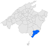
Santanyí is one of 53 independent communities on the Balearic Mediterranean island of Mallorca . It is located in the southeast of the island and borders the municipality of Ses Salines in the west, the municipality of Campos in the north and the municipality of Felanitx in the east . In the municipality are the Puig Gros (271 meters) and the Pena Bosca (280 meters) as the highest peaks. The municipality of Santanyí includes a coastline of approx. 35 kilometers. There you will find the Cap de ses Salines , which marks the southernmost point of the island of Mallorca.
The municipality of Santanyí has an area of 124.47 km² with a population of 12,237 (as of January 1, 2019). This corresponds to a population density of 98 people per km². In 2006 the proportion of foreigners in the municipality was 26.7% (2,979), the proportion of German residents was 9.4% (1,053). In addition to the administrative seat of Santanyí (3379 inhabitants in 2008), the municipality includes the towns of s'Alqueria Blanca (1075 inhabitants), Cala d'Or (4066 inhabitants), Cala Figuera (733 inhabitants), Cala Llombards (400 inhabitants), and Cala Santanyí (370 inhabitants), Calonge (918 inhabitants), es Cap d'es Moro (134 inhabitants), es Llombards (567 inhabitants), Son Moja and Portopetro (633 inhabitants). The official languages are Catalan and Spanish .
City of Santanyí
location
The city of Santanyí is located in the extreme southeast of Mallorca. It is the administrative center of the municipality of Santanyí and is 56 kilometers from the capital Palma and is well connected by the road network.
history
Santanyí was first mentioned in 1236 under the name of Sancti Aini . King Jaume II gave Santanyi town charter in 1300. There are various theories about the origin of the name. The most popular assumes that the name comes from the Latin Sanctus Agnus ("Holy Sheep"). The sheep appears in the municipality's coat of arms. Just like the Romans , the Arabs found themselves in the municipality of Santanyí. In the Islamic era, Santanyí was called Adia. Some place names like s'Almunia still show the influence of the Islamic era. In 1329 Santanyí had 570 inhabitants.
In the following centuries, Santanyí, with its stretches of coast, was repeatedly the scene of pirate attacks. Therefore numerous fortifications were built in the coastal towns. Preserved and worth mentioning are: Sa torre Nova de Sa Roca Fesa (Cala Santanyí), Sa torre d'En Beu (Cala Figuera), Sa torre d'En Bossa (Portopetro) and the Fort Es Forti (Cala d'Or).
In the middle of the 19th century, Santanyí had about 5400 inhabitants. Around 1960 the first tourists came to Mallorca and thus also to Santanyí.
| year | 1842 | 1877 | 1887 | 1900 | 1910 | 1920 | 1930 | 1940 | 1950 | 1960 | 1970 | 1981 | 1991 | 2001 | 2011 |
|---|---|---|---|---|---|---|---|---|---|---|---|---|---|---|---|
| Residents | 5,439 | 6,145 | 5,908 | 6,699 | 6,692 | 7,217 | 5,804 | 5,461 | 5,260 | 5,170 | 5,431 | 5,870 | 6,956 | 8,875 | 13,095 |
Attractions
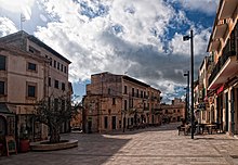
The 18th century church of Sant Andreu is located on Plaça Major . It houses a baroque organ that originally came from the Dominican monastery in Palma. Many famous organists have already played on this instrument, which was built by the well-known royal organ builder Jordi Bosch . Among other things, the organs of the cathedrals of Seville and Murcia come from him . Next to it in the same building complex is the parish church Capella del Roser ("Rosary Chapel") from the 14th century with the ribbed vault . The town hall from 1902 can also be found on Plaça Major.
Towards Palma is the old city gate sa Porta Murada from the 14th century with a tower from the 16th century that represents the rest of the city wall. The gate, which was built from stones on site, has a coat of arms with a poetic text. Particularly noteworthy is the prison inside, which was used to imprison the pirates.
The Santuari de la Consolació is located northwest near S'Alqueria Blanca. The exact date of its construction is not known, but it was first mentioned in 1523. From the Puig de Consolació you have a wonderful panoramic view of Santanyí and the east coast of Mallorca.
The Parc natural de Mondragó , a nature park on an area of 785 hectares between Portopetro and Cala Figuera , is located about five kilometers east of Santanyí. It was set up by the government in 1992. The nature reserve is home to rare orchids , over 70 different species of birds and populations of endangered domestic tortoises. The core of the nature park is formed by the two beaches, sa Font de n'Alis and s'Amarador .
Nearby beaches
- from east to west
- Ses Fonts de n'Alís (Cala Mondragó)
- Caló des Borgit (Cala Mondragó)
- S'Amarador (Cala Mondragó)
- Caló den Perdiu (Cala Mondragó)
- Cala Santanyí
- Cala Llombards
- Caló des Macs
- Caló des Moro
- Cala s'Almunia
- Caló des Savinar
- Caló des Màrmols
- Platja des Caragol
see also: Beaches and bays on Mallorca
market
- Every Wednesday and Saturday morning, except on public holidays, there is a weekly market around the Plaça Major between 9 a.m. and 1 p.m.
Festivals
- January 17th: Sant Antoni (Saint Anthony)
- February 10: Santa Escolàstica (Holy Scholastica)
- first Sunday in March: Dia del santuari del Puig de Consolació (day of the chapel of the Puig de Consolación)
- July 25: Sant Jaume (Saint Jacob), mass with choir concert in the parish church, procession and dance on the Plaça Major of locally important patron saints (Bernardo, who according to legend spoke the language of animals and birds; Barbara, who according to legend possessed great strength and formed rocks into protective towers against advancing enemies), as well as giant man and woman figures (symbolic for the local population), fireworks
- third Saturday in October: Fira de Santanyí (Santanyi fair)
- November 30th: Festivitat patronal de Sant Andreu ( Patron feast of Sant Andreu)
Personalities
born
- Llorenç Vidal i Vidal (* 1936), Spanish educator and pacifist
- Jaume Munar (* 1997), Spanish tennis player
deceased
- Roger Horné (1946–2015), German journalist and television presenter
Individual evidence
- ↑ Cifras oficiales de población resultantes de la revisión del Padrón municipal a 1 de enero . Population statistics from the Instituto Nacional de Estadística (population update).
- ↑ www.visitcalador.com
- ↑ www.visitcalador.com
- ↑ Parc natural de Cala Mondragó
Web links
- Multilingual website of the municipality
- statistical data on the municipality of Santanyí (Catalan)
- The baroque Jordi Bosch organ from Santanyi ( Memento from April 22, 2007 in the Internet Archive )


