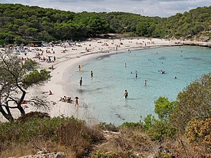
S'Amarador
| S'Amarador beach | ||
|---|---|---|
| location | Santanyí municipality | |
| Geographical location | 39 ° 20 '59 " N , 3 ° 11' 7" E | |
|
|
||
| length | 145 m | |
| width | 50 m | |
| nature | sand | |
| water | clean | |
| Surroundings | natural | |
| tourism | ||
| Visitor frequency | medium to high | |
| Parking spaces | south of the beach (360 m) | |
| monitoring | regularly monitored | |
| Nudism | No | |
| next hospital | Hospital de Manacor (37.9 km) | |
| next port | Portopetro (9.9 km) | |
| Others | Beach bar with lounge chair rental | |
| Beaches and bays in Mallorca | ||
S'Amarador is a sandy beach in the southeast of the Spanish Balearic island of Mallorca . It is located on the west side of Cala Mondragó , a sea inlet with several small side bays on the Mallorcan east coast. In s'Amarador two lead torrents ( torrents ) to the Mediterranean , the southern of which after the beach Torrent de s'Amarador is. Both rarely have water. amarar means "to water / to water". The wet spots were previously used as wet storage for felled tree trunks. The Torrent de s'Amarador forms a wetland in front of the beach with the Estany de s'Amarador pond , which sometimes falls dry.
Location and description
Mondragó Bay is the namesake of a nature park that extends over 765.69 hectares around the bay east of the small town of Santanyí . The Cala Mondragó is about five kilometers east of the city, which is the capital of the municipality of the same name, Santanyí. S'Amarador is the largest of the three sandy beaches of Mondragó , including ses Fonts de n'Alís in the north, on the secondary bay Caló d'en Garrot (also Caló de ses Fonts de n'Alís ), and the beach of the northeastern Caló belonging to the Borgit . The next localities, with the exception of smaller settlements (urbanizations) in the vicinity, are Portopetro in the northeast and the southwestern Cala Figuera .
The beach of s'Amarador is despite the somewhat remote location destination for many tourists. In addition to the guests of the nearby Fonts de n'Alís hotels, it is also frequented by day visitors, which is probably due to advertising by the tourism industry, which markets Cala Mondragó as one of the “most beautiful bays in Mallorca”. Behind the clean sandy beach, which slopes gently into the water, there is a small wooden bar with a few beach loungers and parasols. The western end of the beach to the forest is formed by small dunes, which are covered with beach thistles and beach grass. Due to its protected location within Cala Mondragó , s'Amarador is often visited by private yachts, with bathers and boat traffic being separated from each other by buoys. The beach is regularly monitored by lifeguards.
A coastal footpath leads west and southwest from s'Amarador around Cape Punta de ses Gatoves to the small rocky bay of Caló d'en Perdiu and on to Cape es Blanquer , the southern end of the bay of Cala Mondragó . To the north-east of s'Amarador beach , a concrete path about 300 meters long was built along the rocky coast, which leads to the neighboring beach ses Fonts de n'Alís . There are larger bars and souvenir shops as well as several small hotels in the rear area that were built in the time before the declaration of the nature park. Parts of the nature park area behind the beaches are only accessible to a limited extent, as around 88 percent of the area is privately owned. It is recommended to use the signposted paths. Information on this is available from the nature park administration, which is located at the car park 500 meters above the beach of ses Fonts de n'Alís .
Access
Coming from Santanyí on the MA-6102 in the direction of Cala Figuera, after about 1.9 kilometers at the roundabout, follow the Camí des Cap de sa Paret half left . Through agricultural land, past the small settlement of Cap des Moro, the road ends at the edge of the pine forest that surrounds Cala Mondragó . There is a parking lot there, from which the beach of s'Amarador can be reached on a footpath after about 360 meters.
See also
literature
- Bartomeu Amengual Gomila: Mallorca's coasts from the air . Detailed and practical travel guide with aerial photos of Mallorca's coasts. 6th edition. Editorial GeoPlaneta, Barcelona 2000, ISBN 84-08-01821-3 , Mondragó - S'Amarador, p. 52 (Spanish, original title: Aeroguía del litoral de Mallorca . Translated by Gabriele Grauwinkel and Susanne Pospiech).
- Miguel Ángel Álvarez Alperi: Comprehensive Beach Guide Mallorca + Cabrera . 1st edition. Ediciones El Cohete, Gijón 2001, ISBN 84-87933-08-4 , Platja s'Amarrador, p. 70 .
- Belén Menéndez Solar: Guide de Playas de Mallorca . 1st edition. Ediciones El Cohete, Gijón 2008, ISBN 978-84-87933-11-0 , S'Amarrador, p. 47 (Spanish).
supporting documents
- Mondragó Natural Park , information sheet with maps of the Govern de les Illes Balears, Conselleria de Medi Ambient , available from the Natural Park Administration
Web links
- S'Amarador, Europe's most beautiful beach. Mallorca Zeitung , accessed on August 12, 2014 .
- Beach description (German)
- Beach description ( Castilian )


