Manacor
| Manacor municipality | ||
|---|---|---|
| coat of arms | Map of Spain | |

|
|
|
| Basic data | ||
| Autonomous Community : | Balearic Islands | |
| Island: | Mallorca | |
| Comarca : | Llevant | |
| Coordinates | 39 ° 34 ' N , 3 ° 13' E | |
| Height : | 128 msnm | |
| Area : | 260.22 km² | |
| Residents : | 43,808 (Jan 1, 2019) | |
| Population density : | 168.35 inhabitants / km² | |
| Postal code : | 07500 | |
| Municipality number ( INE ): | 07033 | |
| Nearest airport : | Palma ( Son Sant Joan / Palma de Mallorca , 41 km ) | |
| administration | ||
| Official language : | Catalan , Castilian | |
| Mayor : | Miquel Oliver ( Més ) | |
| Address of the municipal administration: | C / Convent, s / n 07500 Manacor |
|
| Website : | www.manacor.org | |
| Location of the municipality | ||
Mallorca
|
||
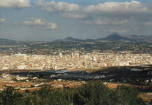
Manacor is the third largest of the municipalities ( Municipi ) on the island of Mallorca and is located in the east of the Balearic Island . It has the status of a city ( Ciutat ) and is also the economic center of the eastern part of the island.
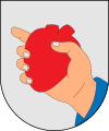
In the modern city arms, a hand that embraces a heart illustrates the folk etymological interpretation of Manacor, namely man a cor "hand on heart". The name of the city comes from the name of the Berber clan Mancur, who inhabited the area before the Catalan conquest. The locals call themselves Manacorí or Manacorina.
geography
Statistical data
The municipality has an area of 260.22 km². In the south it borders on the municipality of Felanitx , in the west on Vilafranca de Bonany , in the north-west on Petra and in the north-east on Sant Llorenç des Cardassar . The coast to the east is 27 km long. On January 1st, 2019 the population was 43,808 registered residents, the population density was 168 inhabitants per km². The population is distributed over the various localities. 69.2% are concentrated in the city of Manacor, while 17.8% live in Porto Cristo . The increase in recent years is remarkable here. The rest is spread over the settlements of S'Illot - Cala Morlanda , Cales de Mallorca , Son Macià , Cala Murada , Cala Anguila - Cala Mendia and Estany d'en Mas . Throughout history, the community's population growth has been similar to that of the rest of the island. In the 16th century there were about 5,000 inhabitants, and the number rose to 7,000 in the 18th century. The most significant increase in population began in the 19th century with almost 13,000 inhabitants at the beginning of the 20th century. Between 1920 and 1940 the number rose to 19,000, after which growth slowed. From the 1960s to the present, the population slowly began to rise again. This last increase is mainly due to the wave of immigration triggered by the economic growth that took place in parallel with the development of tourism. In 2007 the proportion of foreigners in the municipality was 17.5% (6643 people), the proportion of German residents 3.9% (1497 people). In addition, 55 Dutch, 46 Swiss and 23 Austrians lived in the municipality.
Places of the community
The following places belong to the municipality of Manacor:
- Cala Anguila - Cala Mendia (523/523 inhabitants)
- Cala Murada (819/819 inhabitants)
- Cales de Mallorca (836/944 inhabitants)
- Manacor (25,165 / 26,922 inhabitants)
- Son Mas (37 inhabitants)
- Son Talent (30 inhabitants)
-
Porto Cristo (6713/7317 inhabitants)
- Sa Marineta (5 residents)
- S'Estany d'en Mas (207/207 inhabitants)
- S'Illot - Cala Morlanda (1723/1775 inhabitants)
- Son Macià (340/927 inhabitants)
The population figures in brackets are from January 1, 2008. The first number indicates the residents of the built-up areas, the second number the residents of the towns, including the “scattered” population outside the actual settlements. (Source: INE )
Flora
The vegetation consists of the typical plants of Mallorca. A little over 20 percent of the area is covered with forest. In the mountains there are mainly pine forests , whereas there are almost no holm oak forests . The Mediterranean bush forms such Oleaster and fan palm spread along the coast, where species such as cistus , mastic, Bluestem , rosemary and Erika can be found. Beach fennel and astragalus balearicus, among others, grow on the coast , while thistles have almost disappeared from the beaches. Tamarisk and reed thrive in the wetlands . Torrents form the hydrological basis. The Na Borges torrent has a hydrographic basin of 338 km². The streams Son Caules , Conies and Son Cifre flow to it, and it finally flows into the sea in the Bay of Alcúdia . More torrents arise in the hills inland, cross the country and flow into the sea.
climate
The typical Mediterranean climate is moderate and the temperatures are seasonal. The mountainous areas and inland areas are dry, while the coastal strip is semi-arid . The annual average temperatures are 18 ° C.
|
Average monthly temperatures and rainfall for Manacor
Source: Environmental map of Manacor / Umweltatlas Manacor , Ajuntament de Manacor, Delegació de Medi Ambient 2008
|
||||||||||||||||||||||||||||||||||||||||||||||||||||||||||||||||||||||||||||||||||||||
history
The first signs of human settlement in today's municipality of Manacor go back to the pretalayotic period (2000 to 1400 BC), even if the arrival of humans on Mallorca is in the fifth millennium before our era. The artificial burial caves ( cova de Homonet on Son Ribot , Mitjà de les Beies and the Navetes ) are from this period, standing alone or in groups that served as residential buildings ( see also Marineta, s'Hospitalet Vell ).
Around 1400 BC A structural change took place in the prehistory of Mallorca, on the one hand due to the internal development of the pretalayotic society, on the other hand due to the arrival of new tribes from the eastern Mediterranean. A culture emerged that was shaped by its megalithic buildings, of which today only ceramic shards testify. Place names have been preserved which indicate Arabic or Berber origins.
The origin of the city of Manacor is likely to be prior to Islamic rule, as evidenced by the archaeological finds made in the vicinity of the parish church.
Jaume II granted Manacor city rights as early as 1300 . The existence of a parish church was documented as early as 1236. From the beginnings of the city, a former part of the royal palace, the Torre del Palau , and some fortified mansions ( Torre de ses Puntes and Torre dels Enagistes ) have been preserved. In the Middle Ages, Manacor played an important role in the social struggles in which Simó Tort from Manacor was the pioneer.
Urban and social development was particularly marked by the creation of the Sant Vicenç Ferrer monastery and the development of the Fartàritx district . Most of the windmills that characterized the cityscape were located here. In 1576 the Dominican order founded the aforementioned monastery and the construction of the baroque church began. The cloister was built at the beginning of the following century . The monks' property fell into the hands of the state in 1835. Since then the monastery has been the seat of the municipal administration and the court.
Up until the 19th century, Manacor's economy was based on agriculture (growing grain and wine) and raising livestock (sheep), although the textile, food and pottery industries played an important role. In the 19th century the changes began that made Manacor what it is today. The industries for processing agricultural products increased. The windmills and a brandy factory appeared in the cityscape. Furniture production and pearl manufacture have been one of the economic foundations of Manacor since the second half of the century . But pottery and the production of liqueurs and wines are still important.
In 1879 the railway line between Inca and Manacor was inaugurated and the first pearl factory was founded in 1902 . Manacor thus became the commercial and industrial center of the east of the island.
This economic development not only changed the habits of society, but also had an impact on the cityscape, especially since tourism began in the 1960s.
Towards the end of the 19th century, the new parish church Nostra Senyora dels Dolors was built, which stands in the same place as the previous churches. The oldest of them was documented as early as 1232 and was probably built over an Arab mosque (a funerary inscription found that is now kept in the Museu Diocesà in Palma). The most emblematic element is the bell tower. At the same time, some of the most beautiful mansions were built on Nou , Major , Pius XII , Bosch , etc. streets , the historic districts ( Fartàritx and es Barracar ) were expanded and strengthened, and new quarters were built around the station and promenade na Camella . Today the growth of the city takes place mainly in the newer neighborhoods of the school centers and the promenades Port , Fartàritx and Ferrocarril .
During the Battle of Mallorca in the Spanish Civil War , Manacor was the headquarters of the Italian fascist leader Arconovaldo Bonacorsi , known as Conde Rossi , who came to Palma on August 26, 1936 as a military advisor and organizer of the Falange . With the unit established by him, the Dragones de la muerte ("Dragon of Death"), he took part in the fighting at Puig de Son Corb east of Son Servera on September 3, 1936 , in which the August 16 took part in the Republican troops that landed on the east coast of Mallorca were pushed back. After the republican associations withdrew from the island on the night of September 3 to 4, 1936, Bonacorsi was responsible for numerous prisoner executions in Manacor, including five nurses at the Son Coletes cemetery wall on the morning of September 5, who were at a dressing station the Republicans had cared for the wounded just behind the front line at Son Carrió .
| year | 1842 | 1877 | 1887 | 1900 | 1910 | 1920 | 1930 | 1940 | 1950 | 1960 | 1970 | 1981 | 1991 | 2001 | 2011 |
|---|---|---|---|---|---|---|---|---|---|---|---|---|---|---|---|
| Residents | 10,484 | 14,906 | 19,570 | 12,548 | 12,704 | 13,113 | 15,765 | 18,133 | 18,702 | 19,332 | 23,071 | 24.208 | 25,573 | 31,255 | 40,873 |
Culture and sights
historical Museum
The Torre dels Enagistes tower on the road from Manacor to Cales de Mallorca, a protective structure and mansion from the 14th century (following the Catalan conquest in 1229), is now the Museu d'Història de Manacor ("Historical Museum of Manacor" ) with an exhibition of archeology and ethnology. The most notable exhibits are the tomb mosaic of Balèria, one of the mosaics of the early Christian basilica of Son Peretó , and the miniature furniture. Graffiti from the 15th to the 18th century can be seen on the first floor. Admission is free.
Buildings
- The prehistoric settlement of S'Hospitalet Vell on the road from Manacor to Cales de Mallorca (1800–1500 BC), a talayotic settlement . Particularly noteworthy is the talayot, a kind of tower with a square floor plan, of which the Mediterranean column and the roof made of large stone slabs as well as a rectangular enclosure have been preserved.
- The early Christian church of Son Peretó on the road from Palma to Artà was built towards the end of the fifth century AD. It consists of a baptistery with two baptismal fonts and the chapel.
- The convent and cloister of Sant Vicenç Ferrer in Convent Square. The monastery was founded in 1576 by the Dominican Order. The church was built between the end of the 17th and the beginning of the 18th century and has the typical features of the baroque monastery churches of Mallorca: It has a single nave with eight side chapels between arched pillars and barrel vaults. The organ from the 18th century is particularly noteworthy.
- The Church of Nostra Senyora dels Dolors in Rector Rubí Square . The parish church was built in the neo-Gothic style towards the end of the 19th century . It stands in the same place where other churches used to stand. The oldest was documented in 1232 and was probably built over an Arab mosque (an Arab grave inscription found that is now in the Museu Diocesà in Palma). Both structural elements and works of art by local artists have been preserved in the new building. The bell tower is known as Torre Rubí in memory of the builder of the church. It is attached to the apse where the previous church had the main portal. It is the tallest building in Mallorca (80 m), a neo-Gothic work by the architect Gaspar Bennàssar i Moner , which even towers over the cathedral of Palma (67.5 m) with its tower.
- Molí d'en Polit windmill from the 19th century on the main Manacor-Palma road
- Exhibition halls of the Majorica and Perlas Orquídea pearl factories
caves
At Porto Cristo there are the two cave systems Coves del Drac ("Dragon Caves") and Coves dels Hams ("Fish Hook Caves"). The Martelsee in the Coves del Drac is one of the largest underground lakes in the world, where concerts of classical music are performed daily. The Cova de sa Gleda - Camp des Pou in the nature reserve Cales Verges de Manacor near the coast, which is not open to the public, is the longest underwater cave in Europe. Other caves on the coast are the Cova des Pirata , the Cova des Pont , the Cova de sa Piqueta , the Cova des Xots , the Cova des Moro and the Cova de Cala Falcó . There are also several cave systems at Cala Varques , which are named after the bay and numbered differently.
beaches
Platges i Cales (beaches and coves) in the municipality of Manacor (listed from north to south):
Cala Moreia (S'Illot) , Cala Mosca , Cala Morlanda , Caló d'en Rafalino , Cala Petita , Caló de sa Ferradura , Cala Manacor (Platja Porto Cristo) , Cala Murta , Cala Magrana , Cala Anguila , Cala Mendia , S ' Estany d'en Mas , Cala Falcó , Es Caló Blanc , Cala Varques , Racó de sa Teula , Cala Engana Pastor , Cala Sequer , Caló des Serral , Cala Magraner , Cala Pilota , Cala Virgili , Cala Bóta , Caló des Soldat (Caló des Llamp) , Cala Antena , Cala sa Romeguera , Es Domingos Grans , Es Domingos Petits (Cala Tropicana) , Cala Murada
Markets
- Fruit and vegetable market on Plaça Constitució , on weekdays, every morning
- Weekly market on Plaça Ramon Llull , Monday mornings
power supply
electricity
In addition to the supraregional power supply, there are two local solar power plants in the municipality with a total output of around 3.7 megawatts peak (MW p ): The Can Verd solar power plant has been in the city since 2008 and has been in operation since 2011 by the solar power plant built by the German company BayWa District of Porto Cristo added.
natural gas
It is planned to supply Manacor with natural gas. The gas pipeline, which is to be built in the east of the island, is to run from Palma to Manacor and on to Felanitx (as of December 2014).
sons and daughters of the town
- Jaume Santandreu Sureda (* 1938), priest, author and politician
- Joan Riera Ferrari (1942–2017), painter and sculptor
- Miguel Mas (* 1943), track cyclist and world champion
- Luis Ladaria (* 1944), Jesuit, cardinal of the Roman Catholic Church
- Toni Nadal (* 1961), tennis coach
- Miguel Ángel Nadal (born 1966), football player
- Albert Riera (* 1982), football player
- Rafael Nadal (* 1986), tennis player
- Sergi Guardiola (* 1991), football player
Web links
- Pàgina de l'Ajuntament - Community website (multilingual)
- Informació de l'Institut d'Estadística de les Illes Balears - data sheet
- Beaches and bays of the municipality (Spanish)
- Patronage of Sant Antoni
Individual evidence
- ↑ Cifras oficiales de población resultantes de la revisión del Padrón municipal a 1 de enero . Population statistics from the Instituto Nacional de Estadística (population update).
- ↑ Arconovaldo Bonacorsi "conde Rossi". Gran Enciclopèdia de Mallorca, accessed October 11, 2011 (Catalan).
- ↑ Alexander Sepasgosarian: Fighting and Dying in Sa Coma. Mallorca Magazin, September 1, 2011, accessed October 11, 2011 .
- ↑ Alexander Sepasgosarian: A Disgusting Episode . In: Mallorca Magazin . No. 36/2011 . Palma September 8, 2011, p. 26/27 ( online [accessed October 11, 2011]).
- ↑ Natural gas for 630,000 households in the Balearic Islands on Mallorcazeitung.es from August 18, 2014, accessed on December 16, 2014


