Cala Manacor
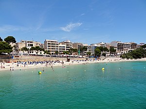
| Cala Manacor beach (Platja des Port) | ||
|---|---|---|
| location | Manacor municipality | |
| Geographical location | 39 ° 32 '29 " N , 3 ° 20' 11" E | |
|
|
||
| length | 200 m | |
| width | 20 m | |
| nature | sand | |
| water | clean, little swell | |
| Surroundings | Local development, port | |
| tourism | ||
| Visitor frequency | high | |
| Parking spaces | in the town | |
| monitoring | Yes | |
| Nudism | No | |
| next hospital | Hospital de Manacor (11.8 km) | |
| next port | Porto Cristo (0 km) | |
| Beaches and bays in Mallorca | ||
Cala Manacor (' Manacor Bay') is a bay in the east of the Spanish Balearic island of Mallorca . The town of Porto Cristo on the coast of the municipality of Manacor with its port, which is important for the region , has been built here since 1888 . The bay is therefore also called it Port de Manacor ('Port of Manacor').
Location and description
The Cala Manacor is located just north of the center of Majorca's east coast, about 23 kilometers southwest of the Cap de Capdepera and 39 kilometers from the Cap de ses Salines away, the southernmost point of Mallorca. The bay is bordered by the Cape Punta des Pagell in the north and Morro de sa Carabassa with its small lighthouse in the south. The distance between the two points is around 260 meters. The capital of the municipality of Manacor is 10.7 kilometers northwest of the entrance to the bay.
Behind the coastline of Cala Manacor , Porto Cristo, the second largest town in the municipality, has developed over the past 120 years. The hinterland of the bay is now completely built on, even if the buildings at the bay entrance are not directly on the shoreline. The Z-shaped sea inlet stretches from the entrance to the bay first to the north, and then swings to the south-west. There is the port entrance, which is shielded from the open sea by a pier .
After about 400 meters, the course of the bay, known within the port as es Riuet ('the river '), swings north again. The port ends at the bridge of the Carretera de les Coves, which cannot be crossed by boats because of its low height . Behind the sea inlet is in the valley of the Torrent de ses Talaioles over, a torrent ( Torrent ) , in the Cala Manacor leads. Between 2004 and 2011 there was a higher bridge on Carrer de Sant Lluís , which had to be demolished for legal reasons.
On the north side of the bay is the approximately 200 meters long and 20 meters wide local beach of Porto Cristo, which is called Platja des Port after the port to the southwest . It consists of fine sand that is cleaned daily. In the season, sun beds and umbrellas are rented and the beach is monitored by lifeguards. There is a demarcation to shipping traffic using buoys . A natural stone wall separates the beach area from Carrer Bordils on the northwest side. East and southeast of the beach are three small caves on the coast of Cala Manacor , the Cova de sa Patroneta , the Coves Blanques and the Cova des Correu . Known for Porto Cristo, touristy undeveloped caves of Drach is located 300 meters southwest of the port.
Access
Porto Cristo can be reached from Manacor on the MA-4020 road. From Son Servera the MA-4023 leads into the village, from Cales de Mallorca the MA-4014. The port at Cala Manacor is the actual center of Porto Cristo. The beach on the north side of the bay is located on Carrer Bordils between Passeig de la Sirena in the southwest at the port entrance and Plaça Costa d'En Blau northeast.
literature
- Bartomeu Amengual Gomila: Mallorca's coasts from the air . Detailed and practical travel guide with aerial photos of Mallorca's coasts. 6th edition. Editorial GeoPlaneta, Barcelona 2000, ISBN 84-08-01821-3 , Portocristo, p. 70 (Spanish, original title: Aeroguía del litoral de Mallorca . Translated by Gabriele Grauwinkel and Susanne Pospiech).
- Miguel Ángel Álvarez Alperi: All the beaches of Mallorca . 1st edition. Laluzenpapel, Gijón 2012, ISBN 978-84-938783-1-3 , Porto Cristo Beach, p. 175 (Spanish, original title: Todas las playas de Mallorca . Translated by Meike Schirmeister).
- Belén Menéndez Solar: Guide de Playas de Mallorca . 1st edition. Ediciones El Cohete, Gijón 2008, ISBN 978-84-87933-11-0 , Portocristo, p. 90 (Spanish).
Individual evidence
- ↑ a b Senderisme a Mallorca. Consell de Mallorca, accessed on August 20, 2016 (interactive map).
- ↑ Frank Feldmeier: Countdown to demolition: The bridge to Porto Cristo. Mallorca Zeitung , August 11, 2011, accessed on August 21, 2016 .
- ↑ Miguel Ángel Álvarez Alperi: Comprehensive beach guide Mallorca + Cabrera . 1st edition. Ediciones El Cohete, Gijón 2001, ISBN 84-87933-08-4 , Platja Portocristo, p. 119 .
Web links
- Beach description (German)
- Beach description ( Castilian )


