Capdepera
| Capdepera municipality | ||
|---|---|---|
| coat of arms | Map of Spain | |

|
|
|
| Basic data | ||
| Autonomous Community : | Balearic Islands | |
| Island: | Mallorca | |
| Comarca : | Llevant | |
| Coordinates | 39 ° 42 ′ N , 3 ° 26 ′ E | |
| Height : | 111 msnm | |
| Area : | 54.92 km² | |
| Residents : | 11,868 (Jan 1, 2019) | |
| Population density : | 216.1 inhabitants / km² | |
| Postal code : | 07580 | |
| Municipality number ( INE ): | 07014 | |
| Nearest airport : | Palma ( Son Sant Joan / Palma de Mallorca , 62 km ) | |
| administration | ||
| Official language : | Catalan , Castilian | |
| Mayor : | Rafel Fernández ( PSOE ) | |
| Address of the municipal administration: | Plaça Sitjar, 5 07580 Capdepera |
|
| Website : | www.ajcapdepera.net | |
| Location of the municipality | ||
Mallorca
|
||
Capdepera is one of the 53 independent municipalities on the Spanish Balearic island of Mallorca . The small town of the same name is the administrative seat of the municipality in the region ( comarca ) Llevant .
The municipality of Capdepera had a population of 11,868 registered residents on January 1, 2019 on an area of 54.92 km². This corresponds to a population density of 216 inhabitants per km². In 2006 the proportion of foreigners in the municipality was 26% (2,877), the proportion of German residents was 14.7% (1,633). The inhabitants of Capdepera call themselves Gabellí , the female Gabellina , in the Mallorcan native language .
The town of Capdepera is characterized by natural stone houses adorned with flowers and narrow cobbled streets. The castle from the 13th century rises on the 159 meter high Puig de Capdepera north above the town. This structure is one of the best preserved fortresses in Mallorca.
geography
Geographical location
Capdepera is the northeasternmost municipality in the Llevant region and the island of Mallorca. The small town of Capdepera is located roughly in the middle of the municipality near the coast. The MA-15 road from the island's capital Palma via Manacor and Artà ends here . The distance to Artá is 6 kilometers, from Palma Capdepera is about 72 kilometers away.
The municipality covers the plain northeast of the mountain ranges of the Serres de Llevant , a low mountain range that extends from the Cap de Ferrutx in the north, in the municipality of Artà, to almost Santanyí near the southern Cap de ses Salines . Capdepera is located on the eastern part of the Artà peninsula and borders the open sea in the north and east, opposite the neighboring island of Menorca .
Neighboring communities
The municipality of Capdepera has only two neighboring municipalities with which it formed an administrative unit until the 19th century. These are Artà to the west and Son Servera to the south-west . The border with Son Servera consists of the Serra de Son Jordi ridge with the 316 meter high Puig de Son Jordi as the highest point.
The border with the municipality of Artà runs in the north on a mountain ridge of a foothill of the Serres de Llevant , starting on the north coast between the bays of Cala Mesquida and Cala Torta up to the 386 meter high Puig des Racó . This is followed by the plain between the cities of Capdepera and Artá to the south, where the border runs west of the only 128 meters high Puig de na Mateva and partly along the stream of the Torrent de sa Farinera .
Community structure
The following places belong to the municipality of Capdepera:
- Cala Rajada (5643/6124 inhabitants)
- Capdepera (3135/3220 inhabitants)
- Cala Gat (55/55 inhabitants)
- Cala Lliteras (696/696 inhabitants)
- Cala Mesquida (62/62 inhabitants)
- Canyamel (420/420 inhabitants)
- Es Carregador ( 61/61 inhabitants)
- Font de sa Cala (252/252 inhabitants)
- Pedruscada ( 214/214 inhabitants)
- Provençals (122/122 inhabitants)
- Son Moll (220/220 inhabitants)
The population figures in brackets are from January 1, 2008. The first number indicates the residents of the built-up areas, the second number the residents of the towns, including the “scattered” population outside the actual settlements. (Source: INE )
Natural space
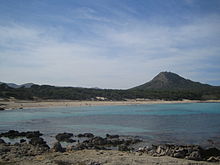
Capdepera is located in the coastal, northeastern plain of the Llevant, from which small, heavily eroded mountain chains (Serras) rise, overgrown with shrub heather ( garriga ) and isolated pines. The coastal strip of Capdepera shows great morphological diversity; there are steep coasts, numerous flat bays and extensive sandy beaches.
Highest elevations in the community:
|
|
climate
The mean rainfall in this area directly on the coast is 500–600 mm per year and further in the interior of the island 600–800 mm. Most of the precipitation falls in October with around 95 mm. The rainiest time is in June and July with only about 12 and 8 mm per month.
history
It is believed that the castle hill could have been inhabited as early as the time of the Talaiot culture , the Balearic variant of the Bronze and Iron Ages , which has been proven by excavations near Artà ( Ses Païsses ) and Canyamel ( Es Claper des Gegants ). Roman navigation maps show a Caput Petrae ('rock spike') at this point - the current name of the place is said to have developed from this term. Before the conquest of this area by Jaume I of Aragón, the Miquel Nunis tower, built by the Moors between the 10th and 12th centuries, was the only structure that stood on the site of today's Castell de Capdepera where it is actually located the protective wall of the later founded settlement Capdepera. In this largely uninhabited area at the time, the Miquel Nunis tower served mainly as a lookout to observe the ship traffic in the Menorca Canal.
In June 1231, King Jaume I stayed at Cap dela Pera with a small troop of soldiers in order to use a ruse to subdue the Muslims of Menorca. According to the sources, the Christians deceived the Muslims in Menorca into the presence of a large armed force by lighting more than 300 fires. After this had been repeated for several nights, the Muslims sent emissaries to the Christians, who signed a peace agreement, which is now kept in the Bibliothèque Nationale in Paris, in which they had to declare themselves vassal of Aragon on June 17, 1231 in Capdepera and pay tribute to this In return, Jakob granted the islanders the freedom to practice the Islamic religion.
The son of the conqueror, Jaume II , initiated the founding of the town of Capdepera in 1300 in order to be able to guarantee the control and defense of this strategically important area. For this purpose, he brought the approx. 200 people living scattered around the area together and let the new settlement be pacified. The farmers, who feared supply bottlenecks and lack of space, followed the call slowly and had to be motivated to relocate through financial incentives. In 1323, under Jaumes successor, Sanç I, an early Gothic chapel was built on the hill . The protective wall, the construction of which was not completed until 1386, was gradually strengthened in the following centuries. The most important function of the facility was to protect the population from attacks by pirates.
When this function became increasingly obsolete towards the end of the 17th century, the residents gradually left the walled area and settled below the hill, where the current settlement gradually emerged. The Castell de Capdepera was a garrison for a dragoon unit until 1854 . In 1858 Capdepera became an independent municipality when the place, like Son Servera , was administratively separated from Artà. The settlement of the coast around Cala Rajada did not take place until the second half of the 19th century. In the 19th century, the church of Sant Bartomeu outside the castle was built. After the withdrawal of the military, the fortress was restored several times under changing owners; since 1983 it belongs to the municipality of Capdepera.
| year | 1842 | 1877 | 1887 | 1900 | 1910 | 1920 | 1930 | 1940 | 1950 | 1960 | 1970 | 1981 | 1991 | 2001 | 2011 |
|---|---|---|---|---|---|---|---|---|---|---|---|---|---|---|---|
| Residents | 1,447 | 2,374 | 2,613 | 2,735 | 2,900 | 2,933 | 3,022 | 3,156 | 3,004 | 3,013 | 4,456 | 5,593 | 6.164 | 8,239 | 11,858 |
Culture and sights
Buildings
Capdepera fortress
The main cultural and historical attraction of the area is the former city wall of Capdepera , known as the Castell de Capdepera. Their floor plan is triangular. A massive defense tower stands in the entrance area (south corner), the portal dates from the 16th century. To the side of it is a smaller defense tower. The fortress walls are completely accessible from here . The houses for the settlers, which were previously located inside the fortress and were built directly on the walls, have been torn down. The former main portal in the west corner is named after Jaume I.
In the north corner at the highest point of the complex is the Nuestra Senyora de la Esperanza chapel , which was originally dedicated to St. Peter and houses a Gothic statue of the Virgin Mary , about which a legend is told: As Capdepera once again from at the end of the 14th century Was attacked by pirates , the residents brought the Madonna to the rescue by taking her out of the chapel and placing it on the walls. After that, the attackers are said to have been miraculously expelled through thick rising fog. Since then the Madonna and her chapel have been called "Nuestra Senyora de la Esperanza". The chapel also houses a statue of Christ made of orange wood , which is dated to the 14th century and was previously painted in color.
The roof of the church, which was once used for defensive purposes ( loopholes can still be seen), now serves as a viewing terrace over the sea to the Cales de Capdepera and the Serres des Llevant .
The cistern on the church forecourt is from the 15th century.
The Miquel Nunis fortress tower is located in the center of the fort, the square basement of which is from the previous Moorish building. A document by Jaumes II reveals the year 1300 as terminus ante quem . Until the 19th century the tower was twice as high as it is today due to its function as a watchtower.
To the south, the residence of the military governor and barracks from the 18th century have been preserved.
caves
Coves d'Artà
The Coves d'Artà are located 50 meters above the coast on a bay east of the town of Canyamel . The name Coves d'Artà dates back to before 1858, as Capdepera was not an independent municipality and, together with Son Servera, belonged to the area of Artà.
Surroundings / beaches
The coastal towns of Cala Rajada, Cala Mesquida , Font de Sa Cala and Canyamel , which - only a few kilometers from Capdepera - are very popular with tourists, are grouped under the name “Cales de Capdepera” .
- At the exit to the north, towards Cala Mesquida with extensive high dunes, you will find a landscape full of wild olives, dwarf palms and mastic bushes, in which nightingales, wrens and robins nest. The Cala Agulla (Cala Guyá) and the Cala Moltó are nature protected with pine-lined dunes.
- In the east is the popular tourist destination of Cala Rajada and to the east of it the rugged Punta de Capdepera peninsula with the Far de Capdepera lighthouse .
- The Cala Son Moll is located a short distance from the center of Cala Rajadas. The beach is quite small and overcrowded in summer, but it is monitored, well connected in terms of traffic and equipped with infrastructural facilities (shower systems, telephone booths, rescue and accident stations, rental stations for umbrellas and loungers as well as restaurants).
- The coastal section in the south leads to Sa Font de sa Cala and leads to the Canyamel region with wide sandy beaches.
golf
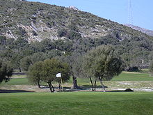
Six kilometers west of Capdepera is an 18-hole course ("Roca viva" or "Golf Capdepera") built by Dan Maples , a golf course architect from North Carolina in the early 1990s, with some sloping slopes on the rocky slopes of the Serra, some even between Olive trees, palm trees and ponds running fairways and clubhouse in finca style.
Other golf courses in the Llevant region are located at Canyamel and Son Servera .
Festivals
- Every year on the third weekend in May, the Mercat Medieval , a medieval craft market with street parades and musical performances , takes place in Capdepera . This tradition has been around since 2000, when it was introduced for the 700th anniversary of the fortress. It is held near the castle. In the stands you can find typical products, from typical food to handicrafts, music, games, etc.
- Capdepera Mare de Déu del Carme from July 10th to 16th, feast of the patron saint of fishermen, with a unique procession of fishing boats at sea. A traditional mass is held with a procession accompanied by music.
- On January 17th, Sant Antoni is celebrated in Capdepera, a festival with Saint Antonio and the devil. On the 16th, the day before, the traditional meeting of the devils is celebrated. On the 17th, the holy day, the "beneïdes" is celebrated. A lot of music is played. It is one of the most glamorous events of the year.
- Cala Rajada: On January 20th, Sant Sebastian is celebrated in Cala Rajada, the same as the Sant Antoni Festival in Capdepera, also with devils walking through the city.
- The feasts of San Roque on August 16 and of San Bartolomeo on August 24 are two festivals that have activities for the whole population. Because the festivals are so close together, they are celebrated together. So almost the whole of August is in her name.
- The Esperanza, Patroness of Capdepera, is commemorated on December 18th. She is a venerated saint who, according to legend, saved the ancient inhabitants of the castle from pirates. Every year she is remembered at the festival “La Esperanza”.
Markets
- Capdepera every Wednesday on the "Placa Orient" and in the streets "Carrer del Castellet i carrer Camamil"
- Cala Ratjada every Saturday in the "Plaza dels Pins"
Economy and Infrastructure
education
According to municipal statistics, a larger proportion of the population in the Capdepera area has no schooling at all (approx. 800 people), and approx. 80 residents are even illiterate. 2,300 people had primary education, 1,000 people had a secondary school leaving certificate. 240 people had completed vocational training, 350 had a high school diploma and 300 had a university degree.
Personalities
The Spanish soccer player Antoni Prats Servera (* 1971) was born in Capdepera.
The Spanish painter Gustavo lives and works on a country estate near Capdepera .
Others
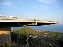
On the Puig de Son Jordi in Capdepera the so-called VOR / DME radio beacon (English colloquial language of the pilots: called Navaid) was set up. It is used for radio navigation in aviation. The antenna in the form of a flat, round plate is very visible to the layman and is often confused with a viewing platform and panoramic restaurant.
Individual evidence
- ↑ Cifras oficiales de población resultantes de la revisión del Padrón municipal a 1 de enero . Population statistics from the Instituto Nacional de Estadística (population update).
- ↑ On the Treaty of Capdepera of June 17, 1231 see Miquel Barceló: El tractat de Capdepera de 17 juny de 1231 entre Jaume I i Abû 'Abd Allāh b. Muhammad de Manurqa. Sobre la funció social i política deis fuqahā , in: Bolletín de la Sociedad Arqueológica Luliana , Vol. 38 (1981), pp. 233-249.
- ↑ Mallorcamagazin: Medieval Market in Capdepera ( Memento of the original from September 3, 2014 in the Internet Archive ) Info: The archive link was inserted automatically and has not yet been checked. Please check the original and archive link according to the instructions and then remove this notice. Retrieved August 29, 2014.
literature
- Patronage of Castell de Capdepera: Castell de Capdepera . Cala Ratjada, 1st edition, 1997
- Gisela Völger: Mallorca Real Travel . DuMont, Cologne 1996


