
Prehistoric settlement of S'Heretat
| Prehistoric settlement of S'Heretat It Claper des Gegants | |||
|---|---|---|---|
 Talaiot of the prehistoric settlement |
|||
Location in Mallorca |
|||
| Coordinates | 39 ° 40 ′ 41.5 " N , 3 ° 25 ′ 55.5" E | ||
| place | Capdepera , Balearic Islands , Spain | ||
| Emergence | around 1000 BC Chr. | ||
| Dimensions | 4800 m² | ||

The prehistoric settlement of S'Heretat ( Mallorcan Poblat prehistòric de s'Heretat ) or Es Claper des Gegants is an archaeological site on the Spanish Balearic island of Mallorca . Claper des Gegants ('stone terrain of the giants') are generally called areas in Mallorcan with remains of cyclopean buildings from prehistory . The so-called ruins on the S'Heretat estate in the municipality of Capdepera dates from around 1000 BC. Chr. It is the culture Talaiot (also Talayotic) at the end of the Bronze Age and the beginning of the Iron Age attributed to the Mallorca 1300-123 v. BC coined.
location

S'Heretat ('the rural property') is located south of the municipal seat of the small town of Capdepera, on the road to Canyamel and the Coves d'Artà . The remains of the prehistoric settlement lie at a height of 50 to 60 meters on a southern slope of the small mountain range Serra Mitjana ('Middle Mountains '), part of the Serres de Llevant, which rises to over 200 meters . From the MA-4042 road to Canyamel, at kilometer 7 about 2.5 kilometers after the roundabout to the MA-4040, a narrow path to the Claper des Gegants is signposted in the northeast . It partly leads along the grounds of the Club de Golf Canyamel golf course, which has been laid out south of the prehistoric settlement since 1988 .
The archaeological site is about 1.8 kilometers away from the east coast of Mallorca at Sa Font de sa Cala . It lies north over a fertile plain that is irrigated by the Torrent de Canyamel . The Torrent flows into the Mediterranean Sea 2.5 kilometers southeast of the prehistoric settlement on Platja de Canyamel . Further remains of buildings from the prehistory of Mallorca near S'Heretat are 5.9 kilometers southwest near Pula in the municipality of Son Servera (two talaiots ) and 6.8 kilometers west in Ses Païsses in the municipality of Artà (talayotic village).
description
The prehistoric settlement of S'Heretat covers an area of approximately 4800 m². The east-west extension is about 110 meters, the north-south extension 65 meters. The terrain rises slightly to the north. The area of the settlement includes different structures of dry masonry remains . The best-preserved buildings are to the west of the site, including a round talaiot , in Catalan talaiot circular .

Already in the book The Balearic Islands. Described in words and pictures (1869-1891) by Archduke Ludwig Salvator , the Talaiot was mentioned by S'Heretat. In late 1888, the French prehistorian Émile Cartailhac visited the Claper des Gegants to study the settlement's talaiot. In his book Les monuments primitifs des Îles Baléares (1892) he published a photo of the Talaiot. After the remains of the structure were uncovered in 1998, several excavation campaigns were planned and carried out under the direction of the archaeologist Lourdes Mazaira . To make it easier for visitors to visit, some paths were laid through the prehistoric settlement area. Despite the exposure, large parts of the area are covered with wild olive trees , dwarf palms and shrubbery .
The surrounding wall of the settlement, of which only remnants have survived, was about 300 meters long. It is interrupted on the west side near the talaiot. In the southwest there was a passage and in the eastern interior there were several buildings attached to the outer wall. In addition to square and rectangular structures, it can be seen that two of the buildings in the center of the settlement had semicircular, apse-shaped sides. The archaeologists assume that the remains of the foundation wall around the talaiot were stables . The talaiot is the best preserved part of the prehistoric settlement. There is a small stone and earth filling between the inner and outer dry stone wall of the rotunda. A passage to the outside was integrated in the lower part of the southeast side.
The Talaiot de s'Heretat has been registered as an archaeological monument (Monument arqueològic) since 1966 under the number RI-51-0001975 .
- Views of the settlement

Remnants of the surrounding wall

South-western open space in front of the talaiot

Interior of the talaiot with an opening to the southeast
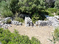
Former stables north of the Talaiot


Individual evidence
- ^ Canyamel Golf - The Club. www.canyamelgolf.com, accessed August 21, 2012 .
- ↑ L'Ajuntament de Capdepera - Architectural walks through the community. The talayot settlement of Es Claper des Gegants. (No longer available online.) Www.ajcapdepera.net, formerly in the original ; Retrieved August 21, 2012 . ( Page no longer available , search in web archives ) Info: The link was automatically marked as defective. Please check the link according to the instructions and then remove this notice.
- ^ Ludwig Salvator of Austria-Tuscany : The Balearic Islands . Described in words and pictures. Second volume. K. u. K. Hofbuchhandlung von Leo Woerl, Würzburg and Leipzig 1897, Das Südostliche Hügelland, p. 142 ( online [accessed August 21, 2012]).
- ^ Laura Jurado: El incrédulo prehistoriador . El Mundo , Madrid September 27, 2011 ( online [accessed August 21, 2012]).
- ↑ Route of the Talayots - Route 5 Pollença, Santa Margalida, Artà, Capdepera. Claper des Gegant. (No longer available online.) Www.conselldemallorca.cat, August 1, 2012, archived from the original on December 24, 2015 ; Retrieved August 21, 2012 . Info: The archive link was inserted automatically and has not yet been checked. Please check the original and archive link according to the instructions and then remove this notice.
- ↑ It Claper des Gegant. www.mallorca-panorama.de, accessed on August 21, 2012 .
- ↑ S'Heretat. Retrieved August 21, 2012 (Spanish).
- ↑ Lourdes Mazeira: Es Claper des Gegant, Capdepera (Mallorca) . Leaflet of the municipality. Ajuntament de Capdepera / Consell de Mallorca, 1998 (Catalan).
- ↑ Lista del Ministerio del Interior. WML files. wmflabs.org, accessed August 21, 2012 .
Web links
- Javier Aramburu-Zabala: Prehistòria. North-est de Mallorca. itinerarioshistoricos.diariodemallorca.es, archived from the original on July 14, 2013 ; Retrieved August 22, 2014 (Catalan).